Recently, Professor He Xiufeng’s research group from the School of Earth Sciences and Engineering at Hohai University, along with collaborators, published a research paper titled “DALI-SLAM: Degeneracy-Aware LiDAR-inertial SLAM with novel distortion correction and accurate multi-constraint pose graph optimization” in the ISPRS Journal of Photogrammetry and Remote Sensing.
LiDAR-Inertial Simultaneous Localization and Mapping (LI-SLAM) plays a crucial role in applications such as robotic navigation and low-cost 3D mapping. However, the performance of existing LI-SLAM systems is still limited by issues such as motion distortion correction, inaccurate pose graph constraints, and degradation of LiDAR features. The existing FAST-LIO2 method utilizes an Inertial Measurement Unit (IMU) for motion distortion correction, but the cumulative error from IMU integration leads to greater correction errors for laser points closer to the end of the frame. Additionally, solid-state LiDARs (e.g., Livox Avia) are affected by low scanning frequency and limited field of view, which can lead to feature degradation. In summary, existing methods do not adequately consider the impact of laser feature degradation on pose estimation, resulting in low pose accuracy in multi-source data fusion. To address these challenges, the research team proposed a precise and robust LiDAR-inertial SLAM method called DALI-SLAM (method flow shown in Figure 1). The contributions of this method are as follows:
A point cloud motion distortion correction method based on dual splines is proposed, which utilizes the registration pose from the current frame to the map and the integrated pose from the IMU to fit a continuous-time trajectory, thereby updating the discrete IMU poses and improving the accuracy of point cloud motion distortion correction.
A degeneracy-aware Kalman filter update strategy is proposed, which introduces a Jacobian matrix remapping algorithm into the tightly-coupled filtering LIO system to mitigate the impact of LiDAR feature degradation on sensor fusion.
A robust variant of the Iterative Closest Point (ICP) method is proposed, accurately constructing three types of pose graph constraints: continuous, co-visible, and loop closure, achieving globally consistent map construction.
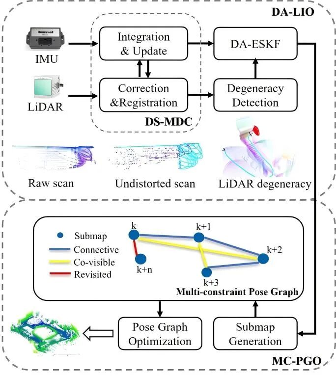
Figure 1: Research Method Framework
The research team collected four sequences of data using a helmet-mounted laser scanning system in typical indoor and outdoor scenarios, comparing and validating the DALI-SLAM method against existing LiDAR-inertial odometry methods and backend optimization methods, fully demonstrating the effectiveness of DALI-SLAM. The results show that the front-end part of this method reduces the root mean square error of the trajectory by 53.9%, 35.1%, and 7.9% compared to the filter-based SOTA method FAST-LIO2; the backend part further reduces the trajectory error by 25.2%, 9.2%, and 52.4%. The 3D mapping comparison results for Sequence 4 are shown in Figure 2.
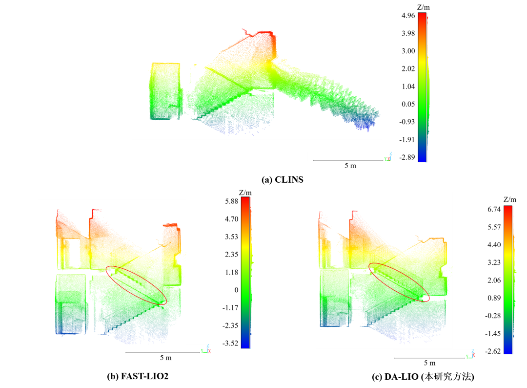 Figure 2: Comparison of Mapping Results for Front-End Method Sequence 4
The first author of the paper is Wu Weitong, a postdoctoral researcher at the School of Earth Sciences and Engineering at Hohai University, with Professor Chen Chi from Wuhan University as the corresponding author. Major collaborators include Professor He Xiufeng from our university, Professor Yang Bisheng, Associate Researcher Liang Fuxun, PhD student Xu Yuhang from Wuhan University, and Postdoctoral researcher Zou Xianghong from Nanchang University. This research work was supported by the National Natural Science Foundation Joint Fund Project, National Key Research and Development Program, National Natural Science Foundation Youth Project, and Basic Scientific Research Business Fee of Central Universities.
Paper Information: Wu Weitong, Chen Chi*, Yang Bisheng, Zou Xianghong, Liang Fuxun, Xu Yuhang, He Xiufeng. (2025). DALI-SLAM: Degeneracy-aware LiDAR-inertial SLAM with novel distortion correction and accurate multi-constraint pose graph optimization. ISPRS Journal of Photogrammetry and Remote Sensing, 221: 92-108.
Original Link:https://www.sciencedirect.com/science/article/abs/pii/S0924271625000413
RECOMMEND
Recommended Reading

Hohai University Students Win Men’s Doubles Championship at National Games!
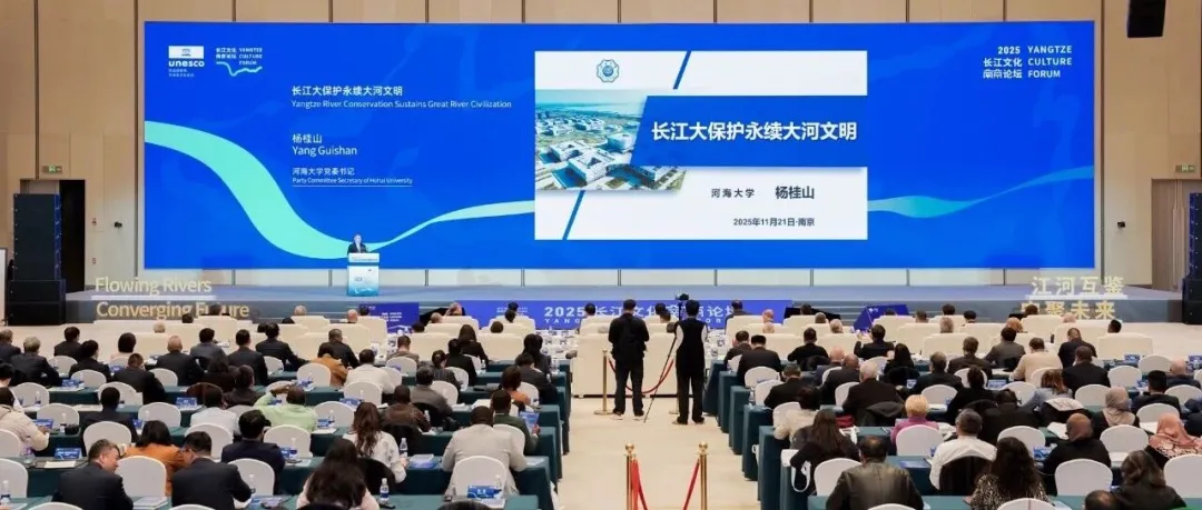
Yang Guishan, Secretary of the Party Committee, Participates in the 2025 Yangtze Culture Nanjing Forum and Delivers Keynote Speech on Sustainable Development of the Yangtze River!

Congratulations! Professor Xie Yimin from Hohai University Elected as Foreign Academician of the Chinese Academy of Engineering!
RECOMMEND
Recommended Reading
Hohai University Students Win Men’s Doubles Championship at National Games!
Yang Guishan, Secretary of the Party Committee, Participates in the 2025 Yangtze Culture Nanjing Forum and Delivers Keynote Speech on Sustainable Development of the Yangtze River!
Congratulations! Professor Xie Yimin from Hohai University Elected as Foreign Academician of the Chinese Academy of Engineering!
Hohai University Students Win Men’s Doubles Championship at National Games!
Source: Hohai University Official Website, School of Earth Sciences