1Drones: What Are They?
Drones, short for Unmanned Aerial Vehicles (UAVs), are uncrewed aircraft that utilize radio remote control devices and onboard programmed control systems. They include unmanned helicopters, fixed-wing aircraft, multi-rotor UAVs, unmanned airships, and unmanned gliders. Broadly speaking, they also encompass near-space vehicles (20-100 km altitude), such as stratospheric airships, high-altitude balloons, and solar-powered drones. From a certain perspective, drones can complete complex aerial missions and various payload tasks in an uncrewed manner, and can be viewed as “aerial robots.”
Based on different platform configurations, drones can primarily be categorized into three platforms: fixed-wing drones, unmanned helicopters, and multi-rotor drones. Other smaller types of drone platforms include glider drones, flapping-wing drones, and unmanned spacecraft. Fixed-wing drones are the mainstream platform for military and most civilian drones, characterized by their high flight speed; unmanned helicopters are the most flexible drone platforms, capable of vertical takeoff and hovering; multi-rotor (multi-axis) drones are the preferred platform for consumer-level and some civilian applications, offering flexibility between fixed-wing and helicopters (requiring thrust for takeoff and landing), but are easy to operate and low in cost.
According to different usage fields, drones can be divided into military, civilian, and consumer categories, with varying performance requirements:
1) Military drones have higher requirements for sensitivity, flight altitude and speed, and intelligence, representing the highest level of technology. This includes reconnaissance, decoy, electronic countermeasures, communication relay, target drones, and unmanned combat aircraft;
2) Civilian drones generally have lower requirements for speed, altitude, and range, but have higher demands for personnel training and overall costs. Therefore, a mature industrial chain is needed to provide the lowest possible cost for components and support services. Currently, the largest market for civilian drones is in government public services, such as police, firefighting, and meteorology, accounting for about 70% of total demand. We believe that the greatest potential market for drones in the future may be in civilian applications, with new market demands possibly emerging in agriculture, logistics, aerial wireless networks, data acquisition, and more;
3) Consumer drones typically use lower-cost multi-rotor platforms for aerial photography, gaming, and other recreational uses.
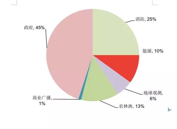
Figure: Composition of the global civilian drone usage fields.
2Drones: Technical Challenges
1. The Flight Control System: The “Pilot” of Drones – More Precise, More Clear
The flight control subsystem is the core system that enables drones to take off, fly in the air, execute missions, and return safely. The flight control system is to drones what a pilot is to manned aircraft, and we consider it one of the core technologies of drones. Flight control generally consists of three main components: sensors, onboard computers, and servo actuators, with functions mainly including drone attitude stabilization and control, mission equipment management, and emergency control.
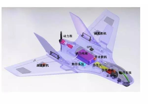
Figure: Aircraft architecture.
Among these, the various sensors (including angular rate, posture, position, acceleration, altitude, and airspeed) extensively installed on the airframe are fundamental to the flight control system and are key to ensuring the accuracy of aircraft control. Different drones have different sensor configuration requirements depending on the flying environment and intended use. Future demands for drone situational awareness, battlefield recognition of friend or foe, and foreign combat capabilities require drone sensors to have higher detection precision and resolution. Therefore, many new technologies, such as hyperspectral imaging, synthetic aperture radar, and ultra-high frequency penetration, are widely used in foreign drone sensors.
2. The Navigation System: The “Eyes” of Drones – Multi-Technology Integration is the Future Direction
The navigation system provides reference coordinate positions, speeds, and flight attitudes to the drone, guiding it to fly along specified routes, akin to a navigator in a manned aircraft system. Drone navigation systems are mainly divided into non-autonomous (GPS, etc.) and autonomous (inertial navigation) types, each with drawbacks of susceptibility to interference and increasing error accumulation. Future drone development requires obstacle avoidance, material or weapon delivery, automated landing, and other functions, necessitating high precision, reliability, and anti-jamming capabilities. Therefore, a combination of multiple navigation technologies, including “inertial + multi-sensor + GPS + electro-optical navigation systems,” will be the direction for future development.
3. The Power System: Turbines Expected to Gradually Replace Pistons; New Energy Engines Enhance Endurance
Drones have different power system requirements based on their intended use, but all desire engines that are small, cost-effective, and reliable: 1) The currently widely used power system for drones is piston engines, but these are only suitable for low-speed, low-altitude small drones; 2) For disposable target drones, suicide drones, or missiles, high thrust-to-weight ratios are required, but lifespan can be short (1-2 hours), generally using turbojet engines; 3) Low-altitude unmanned helicopters typically use turboshaft engines, while large high-altitude long-endurance drones generally use turbofan engines (like the US Global Hawk, which weighs 12 tons); 4) Consumer-grade micro-drones (multi-rotor) generally use battery-powered electric motors, with takeoff weights under 100 grams and endurance times less than one hour.
Looking ahead, we believe that as the thrust-to-weight ratio, lifespan, and fuel consumption of turbine engines continue to improve, turbines will replace pistons as the main power type for drones. New energy electric motors, such as solar and hydrogen-powered engines, are also expected to provide greater endurance for small drones.
4. The Data Link: The “String of the Kite” – Transitioning from Independent Dedicated Systems to Global Information Grid (GIG)
The data link transmission system is a crucial technological component of drones, responsible for remote control, telemetry, tracking, positioning, and sensor data transmission. The uplink data link enables remote control of the drone, while the downlink data link executes telemetry and data transmission functions. Most ordinary drones use customized line-of-sight data links, while medium and high-altitude long-endurance drones typically use both line-of-sight and beyond-line-of-sight satellite communication data links.
The development of modern data link technology is pushing drone data links toward high-speed, broadband, confidentiality, and anti-jamming capabilities, enhancing their practical usability. Looking forward, as onboard sensors, positioning accuracy, and task complexity continue to rise, the demands on data links will become increasingly stringent. With the rapid advancement of onboard high-speed processors, it is expected that within a few years, the transmission rates of existing RF data links will double, and in areas with low all-weather requirements, laser communication methods may emerge.
From the U.S. drone communication network development strategy, the data link system has transitioned from initial IP-based transmission and multi-drone interconnection networks to satellite network transmission and ultimately to a fully global information grid (GIG) configuration, providing authorized users with seamless global information resource interaction capabilities, supporting both fixed and mobile users.
3The Origins of Drone Development
1. Military Technology Spillover and Cost Reduction Ignite the Civilian Market
War is the primary driving force behind drone development, experiencing three major technological development waves in the late 20th century.
Undoubtedly, the initial phase of drone development was purely for military purposes: during World War I, the world’s first drone developed by the UK was defined as a “flying bomb.” By World War II, the German military had begun using large numbers of unmanned bombers in combat; post-World War II, the focus of drone development shifted to the U.S. and Israel, extending their uses to battlefield reconnaissance and intelligence gathering, with drones deployed in Korea, Vietnam, and the Gulf War to assist U.S. and Israeli forces. Due to the inherent advantages of drones in reconnaissance, such as low cost, flexible control, and long duration, military forces worldwide invested heavily in drone system development.
The technology of drones experienced three developmental waves in the late 20th century, entering the first “golden era”: 1) After 1990, over 30 countries globally equipped themselves with division-level (large) tactical drone systems, represented by the U.S. “Hunter” and “Pioneer,” and Israel’s “Scout” and “Pioneer”; 2) Post-1993, medium and high-altitude long-endurance military drones rapidly developed, exemplified by the U.S. “Tier” drone development program, which shone in the Bosnia War; 3) By the end of the 20th century, brigade-level (medium and small) fixed-wing and rotary tactical drone systems emerged, characterized by smaller size, lower prices, and better mobility, marking the era of large-scale drone application.
Early aviation technology addressed the issue of drone flight, while modern technology developments since the 1980s have enabled drones to achieve higher flight performance and better reliability, including: 1) Intelligence: Autonomous flight control technology and rapidly increasing computing power have driven drones toward intelligent development, truly becoming “thinking” aerial robots; 2) High-speed bandwidth: High-speed broadband data links have enabled drone networking and interconnectivity, making drone formations and ground-air equipment integration possible; 3) Lighter materials and sensors: Advances in materials science and micro-electromechanical systems have further reduced drone platform weight and improved accuracy; 4) Enhanced endurance: Significant improvements in battery endurance, as well as new energy technologies, have provided drones with longer flight times.
2. Technology Spillover to Civilian Applications – Drone Industrialization Enters the Popularization Era
Due to the significant advantages of military drones in performing tasks in “3D” (Dull, Dirty, Dangerous) environments and their flexible maneuverability, various civilian sectors eagerly anticipate the application of drones. However, compared to the nearly century-long development history of military drones, civilian drones only began to experiment with applications in the 1980s, following the major advancements in military drone systems, with comprehensive applications across various fields only emerging in the past decade.
Japan has been an early developer of civilian drones: as early as 1983, Yamaha developed a type of unmanned helicopter for pesticide spraying using a motorcycle engine, becoming the first successful unmanned helicopter for test flights in 1989. In 2002, CERP developed a multi-purpose civilian drone; starting in 2003, the Gifu Industrial Association developed four generations of drones over three years, primarily for applications in forest fire prevention and earthquake disaster assessment.
The U.S. NASA established a world-class drone application center in 2003, dedicated to researching the commercial applications of drones equipped with high-resolution camera sensors.
In recent years, the National Oceanic and Atmospheric Administration (NOAA) has used drones to track data related to tropical storms, thereby improving hurricane warning models. During the 2007 forest fires, NASA used the “Ikhana” drone to assess the severity of the fires and estimate disaster losses. After the explosion of the oil drilling platform in the Gulf of Mexico in 2011, drones from Allen Laboratory assisted in oil spill monitoring and management.
Israel has also established a committee for testing civilian drones and their operational modes, granting the “Heron” drone a non-military task execution certificate in 2008 and collaborating with relevant departments to conduct various civilian task test flights.
Europe implemented a “Civilian Drone Development Roadmap” in 2006, and the EU is planning to establish a pan-European civilian drone coordination organization to address key issues of air safety and airworthiness.
China has made early progress and has developed rapidly in recent years: in the 1980s, China attempted to use domestically developed drones (derived from military models) in map surveying and geological exploration. In recent years, the “Qianzhong No. 1” drone was specifically developed for civilian use and successfully made its maiden flight in 2010. In 2011, the domestically produced “Bee 28” drone was capable of fully autonomous takeoff, landing, hovering, and route planning, and can be used in agricultural spraying, power line inspections, disaster response, aerial photography, and communication relays.
In the civilian sector, drones are merely a flying platform; their functions ultimately depend on the task payload equipment within the onboard system.
Compared to the rapid development of drones in various industries for the B2B sector, the consumer drone market for aerial photography and entertainment has seen explosive growth in the past two years, benefiting from the maturity of drone technology and a significant decrease in costs. DJI, founded in 2006, had only a few million in revenue in 2010, but reached 800 million in 2013, nearly 3 billion in 2014, and was valued at 10 billion in 2015.
3. A Mature Hardware Supply Chain and Cost Reduction Create Conditions for the Explosion of Civilian and Consumer Drones
The rise of the civilian and consumer drone market in the past decade is closely linked to the maturity of the hardware supply chain and the continuous decline in costs: with the rise of mobile terminals, the supply chain for chips, batteries, inertial sensors, communication chips, and other components has rapidly matured, leading to cost reductions and enabling the acceleration of the intelligent process toward more miniaturized and low-power devices. This has created favorable conditions for rapid innovation and cost reduction in the overall hardware of drones:
Chips – Currently, a high-performance FPGA chip can achieve dual CPU functionality in drones to meet the information fusion of navigation sensors, enabling optimal control of unmanned aerial vehicles.
Inertial Sensors – With the widespread application of accelerometers, gyroscopes, and magnetometers in Apple’s iPhone, MEMS inertial sensors have been widely adopted since 2011, with 6-axis and 9-axis inertial sensors gradually replacing single sensors, further reducing costs and power consumption, with costs at just a few dollars. Additionally, GPS chips weigh only 0.3 grams and cost less than 5 dollars.
Wifi and Other Wireless Communication – Wifi and other communication chips are used for control and image transmission, with transmission speeds and quality now sufficiently meeting hundreds of meters of transmission needs.
Batteries – The energy density of batteries continues to increase, allowing drones to maintain a lightweight design while achieving endurance times of 25-30 minutes, which is sufficient for basic applications. Furthermore, solar battery technology enables high-altitude drones to fly continuously for a week or even longer.
Cameras and More – In recent years, mobile terminals have also driven significant improvements in the performance and cost reduction of lithium batteries and high-resolution cameras.
4. Open-source Flight Control Systems: Drones Enter Common Households
If the decline in hardware costs solved the “body” issue of drones, the trend of open-sourcing flight control systems in recent years has addressed the “brain” issue of drones. Drones are no longer the exclusive domain of military and research institutions, as commercial enterprises and enthusiasts worldwide have joined the wave of drone system design, igniting the civilian and consumer drone market.
Germany’s MK company is a pioneer in open-source multi-rotor drone systems. In 2011, the U.S. APM company opened its drone design platform, igniting market enthusiasm for drone system development. After 2012, civilian and consumer drones entered an accelerated upward trajectory.
To date, the international drone industry has formed five major open-source platforms: APM (most users), Germany’s MK (the earliest open-source system), Paparazzi (high stability and strong extensibility), PX4, and MWC (strong compatibility).
Taking PPZ (Paparazzi) as an example, it is a fully open-source system that started in 2003, now offering a complete set of mature solutions covering sensors, GPS, automatic driving software, and ground equipment, capable of driving both fixed-wing and rotary-wing aircraft, and can be monitored in real-time via ground control software on satellite maps. The powerful open-source flight control system has ushered drones into the “user-friendly” era.
In October 2014, the renowned open-source system company Linux launched a project called “Dronecode,” which includes major technology companies like 3D Robotics, Intel, Qualcomm, and Baidu, aimed at providing resources, tools, and technical support for drone developers, accelerating development in the drone and robotics fields. According to a report by Teal Aerospace Market Research, the Dronecode project is expected to bring the total value of global drone R&D, testing, and evaluation activities to $91 billion over the next decade. The Dronecode development interface encompasses unmanned ground vehicles, fixed-wing drones, helicopters, and various multi-rotor drones, absorbing multiple platforms like APM and PX4, further promoting the visualization and user-friendliness of system development.
5. Drone-Related Policies: Continuous Improvement of National Policies
China’s Drone Policies: Taking the First Step Towards Regulation
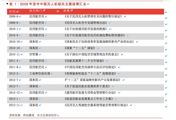
Figure: Summary of major drone-related policies in China from 2009 to the present.
Overall, prior to 2009, drones were in a regulatory blank state. Since 2009, they have begun to enter a licensed flight phase, but laws, regulations, and regulatory enforcement have yet to be perfected and formalized, with actual application procedures remaining vague.
U.S. Drone Policies: Draft for Commercial Drones Finally Released
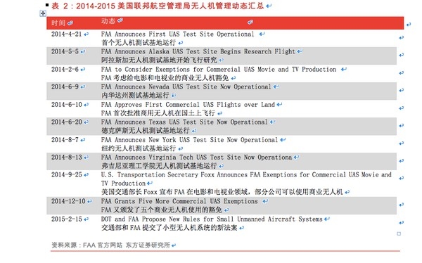
Figure: Summary of U.S. Federal Aviation Administration (FAA) drone management dynamics from 2014 to 2015.
After a long wait and several delays, on February 15, 2015, the U.S. FAA finally announced the long-awaited draft for commercial drone management. This new regulation breaks the previous comprehensive flight ban, but it is still pending finalization.
This rule mainly applies to drones weighing less than 25 kilograms, with restrictions including:
(1) Flight time, speed, and payload limitations: it limits drones to daytime flight and requires them to remain within the visual line of sight of the operator throughout the flight, with a maximum altitude of 150 meters and a maximum speed of 160 kilometers per hour. Drones must not fly over people, and no objects can be dropped from them, nor can packages be attached to the outside of the aircraft.
(2) Flight route and location restrictions: drones must avoid aircraft flight paths and restricted flight zones, strictly adhering to relevant temporary flight restrictions. Drones must stay at least eight kilometers away from airports with manned aircraft.
(3) Operator qualification requirements: drone operators must be at least 17 years old and must obtain a remote pilot certificate from the FAA, passing TSA (Transportation Security Administration) screening.
(4) Additionally, model drones for hobbyists remain unrestricted as long as they do not interfere with air traffic.
UK Drone Policies: The World Leader in Drone Regulations
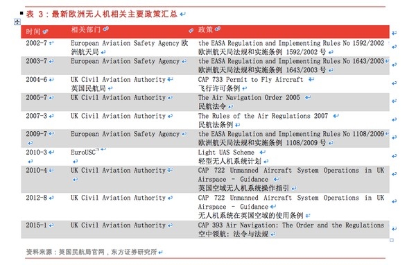
Figure: Summary of major European drone-related policies.
CAP722 is the UK Civil Aviation Authority’s guideline for drone use within UK airspace, with the fourth edition of CAP722 released in April 2010 to adapt to the Air Navigation Law of 2009. All drone regulations are now incorporated into the Air Navigation Law of 2009. Prior to that, CAP722 served as the industry reference standard and has been emulated and implemented worldwide. This document emphasizes the safety requirements regarding airworthiness and operational standards that must be observed before operating drones in the UK. The latest version of CAP722 was released in August 2012 and implements a relatively open policy towards civilian drones. The UK Civil Aviation Authority is a leader in drone regulations.
European Regulation No. 216 of 2008 governs all drones with a total weight exceeding 150 kilograms. The design and production of drones must adhere to the same certification norms as conventional aircraft (led by EuroUSC, which has been authorized by civil aviation authorities to implement light drone programs) and must obtain airworthiness certification or permission to fly. In the UK, drones weighing between 20 and 150 kilograms must have airworthiness qualifications under UK law. If an aircraft operates within 500 meters and below 400 feet or in isolated flight zones, and the drone has certain airworthiness guarantees, the UK civil aviation authority may waive the airworthiness certification requirement. The UK civil aviation authority may also grant waivers based on its investigations and recommendations; currently, only one organization has received this permission. Drones weighing less than 20 kilograms are not subject to many major policy requirements, but the Air Navigation Law No. 98 establishes some conditions, including prohibiting flights in controlled areas or near airports unless permitted by air traffic control authorities, a maximum altitude of 400 feet, and prohibitions on high-altitude operations without special permission from the UK civil aviation authority.
Currently, operating drones under UK aviation law does not require certified pilot licenses. However, the UK civil aviation authority requires all potential drone operators to possess flight qualifications, which can be obtained by completing designated courses, with four certification organizations operating training and examinations.
4The Global Drone Market
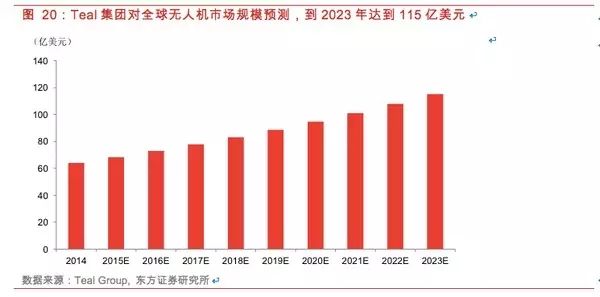
The above image is a prediction by Teal Group regarding the global drone market size, estimating that by 2023, the drone market will reach $11.5 billion.
As for the market share between military and civilian sectors, Teal Group provides a more optimistic assessment for the civilian market (approximately a compound annual growth rate of 9%, reaching $1.5 billion by 2023). Teal Group notably mentions the potential disruptive changes brought to the civilian and military drone industries by high-tech giants such as Google, Facebook, and Amazon, which are currently difficult to quantify.
We believe that the explosive growth of the civilian drone market globally requires overcoming two bottlenecks: airspace resources and safety issues. Once these two issues are resolved worldwide, the imagination of humanity utilizing drones to conquer airspace will be completely unlocked, and the global civilian drone market may experience explosive growth.
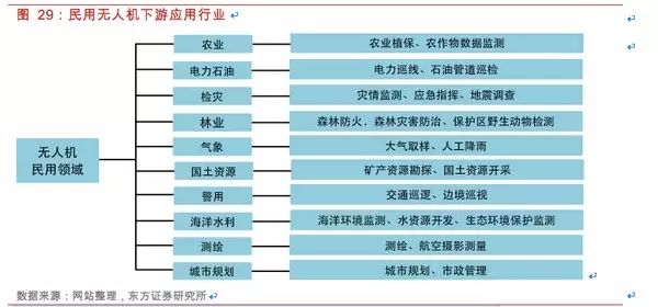
Figure: Downstream application industries for civilian drones.
1. Civilian Drones: Broad Downstream Demand, Entering a Rapid Development Phase
The downstream demand for civilian drones is very broad, encompassing agriculture, electric power and oil, disaster inspection, forestry, meteorology, land resources, police, marine water conservancy, surveying and mapping, urban planning, and more. In recent years, the application of drones in the civilian market has garnered increasing attention, particularly in agriculture and electric power line inspections, where demand is pressing and market size is significant. We believe that potential demand in other industries will gradually emerge, and the civilian drone market in our country has immense potential and is entering a rapid development phase.
Agricultural Protection: The Largest Market for Civilian Drones, with a Market Size Exceeding 10 Billion
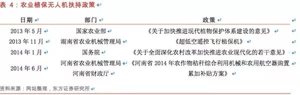
Figure: Support policies for agricultural quality protection drones.
Japan has been using agricultural protection drones for over 20 years, with an annual replacement rate of about 3,000 units. Based on the annual pesticide usage in China and Japan, if China reaches Japan’s current level of agricultural protection drone penetration and usage frequency, the annual replacement rate could reach around 30,000 units, with the market size estimated at 15 billion yuan based on a price of 500,000 yuan per drone.
Power Line Inspections: Policies Expected to Be Issued, Market Size Exceeding 1 Billion
In January 2009, the State Grid Corporation of China officially launched a project to develop an unmanned helicopter inspection system.
In March 2013, the State Grid Corporation issued a pilot work plan for helicopter, drone, and manual collaborative inspection modes for transmission lines. The plan stated that establishing a new collaborative inspection mode involving helicopters, drones, and manual inspections is an urgent need for the development of a strong intelligent grid. Currently, the company’s helicopter inspection operations are gradually developing towards standardization and systematization, and ten inspection companies in Shandong, Hebei, Shanxi, Hubei, Sichuan, Chongqing, Zhejiang, Fujian, Liaoning, and Qinghai have been selected as pilot units to conduct pilot work over two to three years. By 2015, the State Grid Corporation plans to fully promote the new collaborative inspection mode for transmission lines involving helicopters, drones, and manual inspections.
In June 2014, the China Electric Power Enterprise Federation’s Standardization Center publicly solicited opinions on a draft industry standard titled “Technical Guidelines for Drone Inspection Operations on Overhead Transmission Lines.” We expect the industry standard from the Electric Power Federation to be formally issued this year.
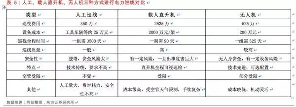
Figure: Comparison of inspection methods using manual, manned helicopters, and drones.
China has approximately 52,000 kilometers of high-voltage transmission lines above 110kV. Assuming an inspection frequency of 30 times per year, the total inspection length is approximately 15.6 million kilometers annually. Drones can inspect 20 kilometers per hour, and assuming an annual flight time of 150 hours per drone, around 5,200 drones would be needed nationwide. At a cost of 200,000 yuan per drone, the annual market size would be approximately 1.04 billion yuan.
Forest Fire Prevention: Urgent Demand, Still in Initial Stages
China has a forest area of 175 million hectares, with a forest stock volume of 12.456 billion cubic meters and a forest coverage rate of 18.21%. It is both a major forest resource country and one prone to forest fires.
Currently, many new technologies and equipment are used abroad for forest fire prevention, and domestic demand for such applications is increasing, with investments in forest protection gradually increasing. Satellite technology has been used for resource surveys and forest fire monitoring, while the use of drone systems for forest fire monitoring is still in its initial stages.
Disaster Inspection: National Needs, Broad Space
The 2008 Wenchuan earthquake caused numerous secondary geological disasters, such as landslides, mudslides, and dammed lakes, resulting in severe damage to major national and provincial roads, making rescue efforts extremely challenging. Due to weather factors, satellite remote sensing systems and manned aerial remote sensing systems struggle to obtain timely ground images of disaster areas. After the earthquake, various models of drone aerial remote sensing systems quickly entered the disaster area, widely used for disaster assessment, landslide monitoring, damage assessment of buildings and roads, evaluation of rescue efforts, and post-disaster recovery, achieving significant results and fulfilling roles that other methods cannot replace. The use of drone aerial remote sensing systems for emergency disaster relief was successfully implemented on a large scale for the first time.
During the 2013 Ya’an earthquake rescue, the National Earthquake Disaster Emergency Rescue Team used rotary-wing drones to conduct aerial surveys of the disaster area’s terrain and damage, providing reference and basis for the rescue team’s operations. This drone was jointly developed by the National Earthquake Disaster Emergency Rescue Team and the Shenyang Institute of Automation, Chinese Academy of Sciences, achieving a detection accuracy of 0.1 meters and capable of flying continuously for 100 kilometers at an altitude of 200 meters.
China experiences frequent natural disasters, causing significant annual losses. During disasters, timely and accurate information is crucial for improving rescue efficiency and quality. Conventional disaster monitoring methods are lengthy and costly, making it challenging to meet emergency needs. Drone aerial remote sensing systems, as a complementary method to satellite and manned aerial remote sensing, offer advantages of real-time capability, flexibility, minimal external environmental impact, and low cost, providing broad development space and application prospects for emergency disaster relief.
2. The Consumer Drone Market is Rapidly Heating Up
This year, the global drone market has attracted widespread attention, with DJI’s innovative products taking center stage. Domestic companies like XAG Technology, Zero Zero Robotics, and foreign companies like 3DRobotics are continuously launching products and securing financing, marking 2015 as the inaugural year for consumer drones.
DJI is the world’s leading small drone manufacturer, holding about 50% of the global market share for civilian small drones, with 80% of its products sold abroad. It is regarded as a world-class drone company that can be compared to Apple in Silicon Valley. Founded in 2006, DJI initially focused on controllers for drones, then identified the market for aerial photography and transitioned to producing complete systems and stable flight platforms, as well as high-definition digital video transmission modules, ultimately dedicating itself to providing comprehensive aerial imaging strategies. In just a few years, the company grew exponentially, reaching a revenue scale of 800 million yuan in 2013, recognized by TIME magazine as one of the top ten innovative tools globally in 2014.
DJI’s drones are widely used for aerial photography and are favored by both professional and amateur photographers. Its product line includes the mid-range Phantom series and the high-end Inspire series, which dominate the high-end market. They have been featured in popular TV shows like “Where Are We Going, Dad?” and in hit dramas like “Agents of S.H.I.E.L.D.” and “Homeland.” Users have also employed them for panoramic scanning of the Christ the Redeemer statue in Rio de Janeiro, close-up shots of whales, and flying over erupting volcanoes.
In addition to DJI, interest from technology companies at home and abroad in drones has rapidly increased. Drones are no longer just “toys” for aerial photography but are seen as revolutionary robots for the future: Amazon’s PrimeAir logistics plan has entered its ninth generation of development; Google acquired the drone company Titan Aerospace to provide network coverage; Facebook also purchased the UK drone company Ascenta for $20 million; 3DRobotics has secured $50 million in investment; and Matternet is building a drone network to deliver food and medical supplies to remote rural areas globally.
The domestic drone market is also gradually emerging, with companies like DJI, Zero Zero Robotics, XAG Technology, Yihang UAV, and Tianxiang UAV coming to the forefront. On January 20, 2015, Rapoo Technology and Zero Zero Robotics jointly established a joint venture to develop drones, launching the ZERO consumer-grade quadcopter series on February 1, 2015, available for pre-sale on Zero Zero’s official website and some e-commerce platforms, starting at 3199 yuan.
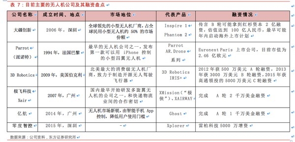
Figure: Overview of major drone companies and their financing.
Currently, drones are mainly applied in aerial photography and various industry applications, including border defense and agriculture. For example, DJI is primarily used for aerial photography, while XAG Technology serves various industry applications. Additionally, security monitoring applications such as search and rescue and theft prevention are also in their infancy. Attempts to use drones for logistics are increasing, with Amazon having conducted research for many years, and the domestic express delivery industry also beginning to explore this area.
Google’s Project Loon aims to create a network of stratospheric balloons worldwide, and it has also acquired Titan Aerospace to provide solar-powered drones, both of which can provide low-cost internet access globally.
NASA is also developing a “low-altitude traffic management system” for drones, expected to be used in agriculture in 2015. Drone manufacturer Skycatch focuses on data collection for construction, mining, solar energy, and agriculture, having previously secured $13.2 million in financing. Other innovative applications include bee-sized drones for pollinating flowers.
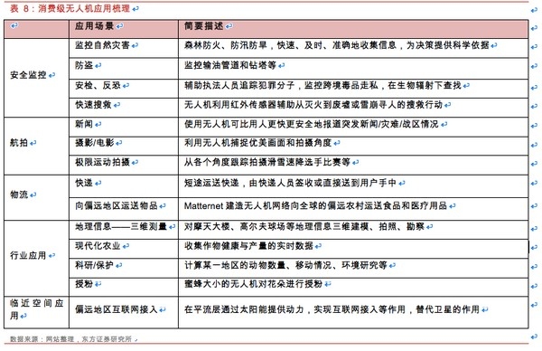
Figure: Summary of consumer application drones.
GoPro joined the “small drone alliance” last year and has launched video camera equipment for multiple drone models, announcing its entry into the consumer drone market, with its first multi-motor drone expected to launch this year, priced between $500 and $1000. DJI has also announced plans to use self-developed cameras in future drone products. The combination of drones and action cameras will be an important application for drones in personalized aerial photography in areas such as sports and health, such as the STELLA drone, which is designed specifically for the GoPro Hero3 series camera.
Drones can also be used with Oculus Rift to provide virtual reality and augmented reality experiences. For example, Parrot has launched a wireless control accessory called Skycontroller, which connects to Oculus Rift via HDMI, allowing users to control the flight path of the drone directly. This connection method brings people’s perceptions into another real space. Such experiences may also find applications in tunnels, canyons, and underwater scenes, allowing explorers to enjoy thrilling sensory experiences without physically being present, eliminating the need for significant resources to model and create a virtual world, making any location a new playground.
Based on DJI’s revenue of approximately 3 billion yuan last year and the pricing of several thousand to tens of thousands of yuan, the shipment volume of drones is in the hundreds of thousands, indicating significant future growth potential. According to Teal Group, the global civilian drone market size reached $2.8 billion in 2014 and is expected to experience unprecedented continuous growth over the next decade, with the market size projected to more than double.
5What Can Drones Do for Us in the Future?
In addition to the military, commercial, and consumer functions we are already familiar with, drones capable of “flying in the sky and entering the ground” may bring infinite surprises to our lives. At an altitude of 300 meters, free from ground congestion and various restrictions, drones in the future may not only serve as super delivery personnel and super police but also provide low-cost, highly mobile wireless network coverage to the ground. By envisioning drones as “flying sensors,” they become aerial data ports for Industry 4.0, collecting data on everything from geophysics and meteorology to agricultural data and personal location information, igniting a big data revolution in the sky!
1. Aerial Data Ports for Industry 4.0!
We believe that as “flying sensors,” drones may have the most imaginative applications in the civilian sector as aerial data ports, providing more precise and powerful data streams for the global “big data” system of Industry 4.0.
Starting with the common inspection function of drones, using drones to survey farmland nationwide can provide clearer observations of crop growth, natural disasters, and soil changes compared to satellite images. Drones can connect to the global internet to transmit collected data in real-time to commodity analysts, helping to assess trends in global agricultural futures markets. In future precision agriculture systems, small drones can be used to monitor whether crops need water, feeding this information back to irrigation systems to adjust water levels.
Regarding personal data acquisition, drones can simulate WiFi hotspots, sniffing the MAC addresses of mobile devices and triangulating based on signal strength to gather information, which can be compiled into a user movement map, showing the neighborhoods and stores they typically pass by, allowing for targeted promotions to potential consumers who have not entered a store. By tracking personal movement trajectories, businesses can gain a more comprehensive understanding of consumer habits, providing more precise reference data. Additionally, in emergencies, drones can locate individuals by detecting Wi-Fi signals from their mobile devices.
This technology is somewhat similar to indoor mobile device positioning technologies like iBeacon, which push promotional information when users pass by. The difference is that drones are more flexible and can locate users in more complex geographical conditions.
2. Tech Giants’ Next Stop: Providing Flexible, Low-Cost WiFi Network Access
With nearly four billion people globally still lacking internet access, solving the problem of internet connectivity, such as WiFi network deployment, has become one of humanity’s top ten challenges. Drones, with their low energy consumption and long flight times, can provide internet access services to a larger user base. Additionally, drones possess strong maneuverability, allowing them to offer internet access services based on specific needs in certain areas.
Google Acquires Titan to Capture the Internet Coverage Market: In April 2014, Google acquired the drone company Titan Aerospace. Founded in 2012, Titan Aerospace aims to replace high-cost near-Earth satellites with its drones. They have successfully developed and begun testing the Solara 50 and 60 drones, which can fly at low Earth orbit for five years without landing, powered by solar energy. The Solara drone is 50 meters wide, can carry 32 kg, and can achieve speeds of 104 km/h, with Titan stating that their high-altitude drones can provide network access at speeds of up to 1 GB per second through specialized equipment.
It is said that after the acquisition, Titan Aerospace will collaborate with two of Google’s projects, one of which is Project Loon, which provides internet services through high-altitude balloons. Furthermore, Google plans to invest $1 billion in satellite-based internet coverage. By employing a combination of balloons, drones, and satellites, along with the ongoing rollout of wired fiber connections via Google Fiber, it is evident how critical Google considers internet access.
However, wired access primarily enhances service quality in already covered areas, while the first three wireless access methods mainly address coverage issues. Relatively speaking, drone technology may offer advantages over balloons, as Titan Aerospace’s drones are solar-powered with a potential endurance of up to a year, while the deployment costs and maintenance challenges of balloons are relatively high. Moreover, drones can fly higher than commercial aircraft yet lower than satellites, allowing them to provide stable high-speed access of 1 Gbps. Thus, Google’s drones may provide high-capacity services in small areas while satellites cover low-rate demand regions.
Facebook Aims for the Next Billion Users with Drones Covering Remote Areas
Facebook has established the Connectivity Lab, tasked with developing various internet connection technologies, including satellites and drones. Facebook has also acquired Ascenta, another company providing similar technologies, for $20 million. Ascenta’s solar-powered drones can fly at 20 km high and remain airborne for up to a month. Facebook’s involvement in drones is primarily aimed at providing network services to remote residents, attempting to win over the next billion users.
3. Flying Delivery Personnel
The most famous drone delivery service is Amazon’s Prime Air logistics plan. At the end of 2013, Amazon unveiled an eight-winged drone called Prime Air capable of transporting packages weighing up to five pounds. Amazon continues to focus on the shopping sector, offering users endless choices, the lowest prices, and the promise of immediate delivery in the future. Amazon’s Prime Air has now entered its ninth generation, capable of carrying five-pound packages, covering 86% of product categories, and flying at speeds exceeding 50 miles per hour. They have formally applied to the FAA for broader outdoor flight testing. Additionally, Google and UPS have been testing drones for delivery since 2012-2013.
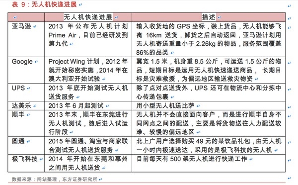
Figure: Progress of drone delivery.
With the introduction of high-performance drones from companies like DJI, drone delivery can significantly reduce the logistics costs of the “last mile”:
Energy Cost Per Order Less Than 0.1 Yuan – Assuming a payload of 2 kilograms, for a package delivered within a 10 km range, the direct hardware cost (mainly energy costs) is less than 0.1 yuan per order, consuming about 10Ah of power, totaling approximately 40Wh, costing about 0.03 yuan;
Amortized Cost of Drones – Assuming a drone costs 5000 yuan with a 5-year operational life and a 20% annual maintenance cost, the total cost would be around 6000 yuan, or about 4 yuan per day. If each drone completes 10 tasks daily, the amortized cost per package would be 0.4 yuan;
Combining these factors leads to a total cost of less than 0.5 yuan per order, which represents a significant reduction compared to current manual logistics costs, indicating that drone delivery has clear economic benefits.
The most challenging aspect of drone logistics is the final delivery stage, as simply knowing the GPS coordinates of the destination is insufficient. Recently, methods have been developed in Australia, where drones are equipped with cameras, and large boxes with specific markings are placed on users’ balconies, enabling drones to accurately deliver packages using machine vision.
Moreover, regulations remain the biggest obstacle. Recently, the U.S. Federal Aviation Administration (FAA) announced a new draft for drone management regulations,
In the proposed new rules by the FAA, drones must remain within the operator’s visual line of sight. This primarily limits the commercial use of drones for photography, surveying, search and rescue, and crop monitoring, which is unfavorable for drone delivery services.
4. Aerial Guardians for Personal Safety
With various functionalities such as logistics delivery, information monitoring, and aerial photography, the emergence of drones capable of recording our daily lives may soon become a reality. For instance, the “Mind4” quadcopter developed by AirMind in Shanghai is dubbed the “Tracker Drone” because it can follow and capture footage of designated individuals or targets.
The design concept of “Mind4” is to document our lives, even capturing non-human entities. The camera equipped on the “Mind4” can cover distances beyond 20 meters from the designated target. With its automatic navigation capabilities, the “Mind4” can reach a maximum height of 20 meters while tracking a selected target, trailing up to 50 meters behind. Furthermore, it can be controlled through gestures.
Quadcopters equipped with built-in cameras are now widely available, yet most still require remote control. GPS-based tracking technology does not ensure precision regarding the object’s location (i.e., the direction the camera is pointing) because civilian GPS is often imprecise.
Considering the rapid development of consumer drone products over the years, the emergence of products like “Mind4” is perhaps not surprising. More mature drones capable of tracking and recording designated targets may offer comprehensive monitoring and protection for personal safety in the future. Imagine a future where a fleet of drones tracks and scans for dangers while your child is at school or playing, ensuring their safety.
This article is sourced from: General Aviation Home