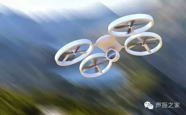
 Drone
Drone
1. What is a Drone
A drone is short for Unmanned Aerial Vehicle (UAV), which is an uncrewed aircraft that uses radio remote control equipment and self-contained program control devices. This includes unmanned helicopters, fixed-wing aircraft, multi-rotor aircraft, unmanned airships, and unmanned gliders. Broadly speaking, it also includes near-space vehicles (20-100 kilometers altitude), such as stratospheric airships, high-altitude balloons, and solar-powered drones. From a certain perspective, drones can complete complex aerial missions and various payload tasks under unmanned conditions, and can be seen as “aerial robots.”
According to different platform configurations, drones can mainly be classified into three major platforms: fixed-wing drones, unmanned helicopters, and multi-rotor drones. Other small types of drone platforms include glider drones, flapping-wing drones, and unmanned spacecraft. Fixed-wing drones are the mainstream platforms for military and most civilian drones, characterized by high flight speeds; unmanned helicopters are the most flexible drone platforms, capable of vertical takeoff and hovering; multi-rotor (multi-axis) drones are the preferred platform for consumer and some civilian purposes, with flexibility between fixed-wing and helicopters (takeoff and landing require thrust), but they are easier to control and lower in cost.
According to different fields of use, drones can be divided into military, civilian, and consumer categories, each with varying performance requirements:
1
Military drones have higher requirements for sensitivity, flight altitude and speed, and intelligence, making them the most technologically advanced drones. This includes reconnaissance, decoy, electronic countermeasures, communication relays, target drones, and unmanned combat aircraft;
2
Civilian drones generally have lower requirements for speed, altitude, and range, but have higher demands for personnel training and overall costs, necessitating a mature industrial chain to provide low-cost components and support services. Currently, the largest market for civilian drones is in government public services, such as police, firefighting, and meteorology, accounting for about 70% of total demand. We believe that the most promising market for drones in the future may lie in civilian applications, with new market demands potentially emerging in areas like agricultural protection, cargo delivery, aerial wireless networks, and data acquisition;
3
Consumer drones typically use lower-cost multi-rotor platforms for aerial photography, gaming, and other recreational uses.
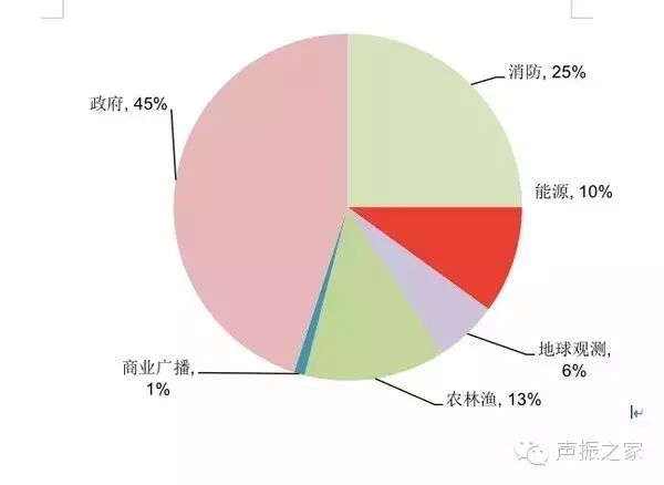 Global Civilian Drone Usage Fields
2. Technical Challenges of Drones
1The Flight Control System is the “Pilot” of the Drone – More Precise and Clear
The flight control subsystem is the core system that allows the drone to complete the entire flight process, including takeoff, aerial flight, mission execution, and return recovery. The flight control system is to a drone what a pilot is to a manned aircraft, and we consider it one of the most critical technologies in drones. Flight control generally includes three main parts: sensors, onboard computers, and servo actuators, and its primary functions include stabilizing and controlling the drone’s attitude, managing mission equipment, and emergency control.
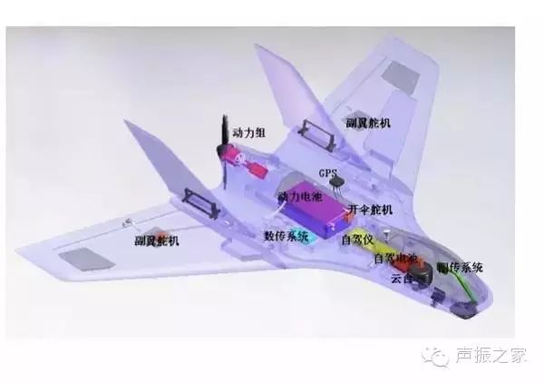
Aircraft Structure
Among them, the various sensors (including angular rate, attitude, position, acceleration, altitude, and airspeed) installed throughout the aircraft are the foundation of the flight control system and are key to ensuring the precision of aircraft control. Different drones have varying sensor configuration requirements based on different flying environments and purposes. Future demands for drone situational awareness, battlefield identification of friend or foe, and area denial capabilities require drones to have higher detection precision and resolution. Therefore, many new technologies such as hyperspectral imaging, synthetic aperture radar, and ultra-high frequency penetration are widely used in foreign drone sensors.
2The Navigation System is the Drone’s “Eyes” – Multi-Technology Integration is the Future Direction
The navigation system provides reference coordinates for the position, speed, and flight attitude of the drone, guiding it to fly along a specified route, similar to a navigator in a manned aircraft system. The onboard navigation system of drones is mainly divided into non-autonomous (GPS, etc.) and autonomous (inertial guidance) systems, but each has disadvantages such as susceptibility to interference and increased error accumulation. Future developments in drones require functions such as obstacle avoidance, material or weapon delivery, and automatic landing, necessitating high precision, high reliability, and high anti-interference performance. Therefore, a combined navigation technology of “inertial + multi-sensor + GPS + electro-optical navigation system” will be the direction of future development.
3Power System – Turbines are Expected to Gradually Replace Pistons, New Energy Engines Enhance Endurance
Different uses of drones have varying requirements for power systems, but all hope for engines that are small, low-cost, and reliable: 1) The currently widely used power device for drones is the piston engine, but it is only suitable for low-speed, low-altitude small drones; 2) For disposable target drones, suicide drones, or missiles, a high thrust-to-weight ratio is required, but lifespan can be short (1-2 hours), typically using turbojet engines; 3) Low-altitude unmanned helicopters generally use turboshaft engines, while large unmanned drones for high-altitude long-endurance missions generally use turbofan engines (the U.S. Global Hawk weighs 12 tons); 4) Consumer-grade micro-drones (multi-rotor) generally use battery-powered electric motors, with takeoff weights under 100 grams and endurance times under one hour.
Looking ahead, we believe that as the thrust-to-weight ratio, lifespan, and fuel efficiency of turbine engines continue to improve, turbines will replace pistons as the main power type for drones, and new energy electric motors such as solar and hydrogen energy are also expected to provide longer endurance for small drones.
4The Data Link is the “String for Flying Kites” – Transitioning from Independent Dedicated Systems to Global Information Grid (GIG)
The data link transmission system is an important technical component of drones, responsible for remote control, telemetry, tracking, positioning, and sensor data transmission. The uplink data link enables remote control of the drone, while the downlink data link executes telemetry and data transmission functions. Most ordinary drones use customized line-of-sight data links, while medium-to-high altitude, long-endurance drones typically use both line-of-sight and beyond-line-of-sight satellite communication data links.
The development of modern data link technology is driving drone data links towards high speed, broadband, confidentiality, and anti-interference. The practical capabilities of drones will continue to strengthen. Looking ahead, as the precision of onboard sensors and the complexity of mission execution continue to rise, the demands on data links become increasingly stringent. As onboard high-speed processors advance rapidly, it is expected that the transmission rate of existing RF data links will double in a few years. In areas with low all-weather requirements, laser communication methods may also emerge in the future.
From the U.S. drone communication network development strategy, the data link system is transitioning from initial IP-based transmission and multi-machine interconnection networks to satellite network transmission, ultimately leading to a fully global information grid (GIG) configuration that provides authorized users with seamless global information resource interaction capabilities, supporting both fixed and mobile users.
3. The Origins of Drone Development
1Military Technology Spillover and Cost Reduction Ignite the Civilian Market
War is the primary driving force behind the development of drones, experiencing three major technological development waves in the late 20th century.
Undoubtedly, the early development of drones was purely for military purposes: the world’s first drone developed by the UK during World War I was defined as a “flying bomb”; during World War II, the German military began to extensively use unmanned bombers in combat; after World War II, the center of drone research and development shifted to the U.S. and Israel, with uses extending to battlefield reconnaissance and intelligence gathering, with drones being deployed in Korea, Vietnam, and the Gulf War to assist U.S. and Israeli forces in combat. Due to the natural advantages of drones in reconnaissance, such as low cost, flexible control, and long duration, military forces around the world invested heavily in the development of drone systems.
Drone technology experienced three development waves in the late 20th century, truly entering the first “golden age”: 1) After 1990, over 30 countries worldwide equipped tactical drone systems at the division level (large), with representative models including the U.S. “Hunter” and “Pioneer”, and Israel’s “Scout” and “Pioneer”; 2) After 1993, medium-to-high altitude long-endurance military drones developed rapidly, represented by the U.S. “Tier” drone development program, which shone during the Bosnian War; 3) At the end of the 20th century, brigade-level (medium-small) fixed-wing and rotary tactical drone systems emerged, characterized by small size, lower prices, and good maneuverability, marking the entry of drones into a large-scale application era.
Early aviation technology addressed the problem of enabling drones to fly, while modern technological developments since the 1980s have provided conditions for higher flying performance and better reliability for drones, including: 1) Intelligence: Autonomous flight control technology and rapidly increasing computer processing capabilities have propelled drones towards intelligent development, truly becoming “thinking” aerial robots; 2) High-speed bandwidth: High-speed broadband data links have made it possible for drones to network and interconnect, enabling drone formations and joint operations with ground equipment; 3) Lighter materials and sensors: Advances in material science and micro-electromechanical systems have further reduced the weight of drone platforms and improved precision; 4) Stronger endurance: Significant improvements in battery endurance and new energy technologies have granted drones longer flight times.
2Technology Spillover to Civilian Use, Drone Industrialization Enters the Popularization Era
Due to the significant advantages of military drones in executing tasks in “3D” (DULL, DIRTY, DANGEROUS) environments and their flexible maneuverability, various civilian sectors are eagerly anticipating the application of drones. However, compared to the nearly century-long development history of military drones, civilian drones only began to attempt applications on the foundation of significant advancements in military drone systems in the 1980s, with comprehensive applications in various fields only emerging in the last ten years.
Japan developed civilian drones relatively early: as early as 1983, Yamaha used motorcycle engines to develop a type of unmanned helicopter for pesticide spraying, which became the first successful unmanned helicopter in practical flight in 1989. In 2002, CERP developed a multi-purpose civilian drone; starting in 2003, the Gifu Industrial Association developed four generations of drone products over three years, mainly used in forest fire prevention and earthquake disaster assessment;
In recent years, the U.S. National Oceanic and Atmospheric Administration has used drones to track data related to tropical storms, improving hurricane warning models. In 2007, during widespread forest fires, NASA used the “Ikhana” drone to assess the severity of the fire and estimate disaster losses. After the explosion of the oil drilling platform in the Gulf of Mexico in 2011, drones from Allen Laboratory assisted in oil spill monitoring and response.
Israel has also established a special committee for testing civilian drones and their operational modes, granting the “Heron” drone a non-military mission execution certificate in 2008 and collaborating with relevant departments to conduct various civilian mission test flights.
Europe implemented a “Civilian Drone Development Roadmap” in 2006, and subsequently, the EU proposed to establish a pan-European civilian drone coordination organization to address critical issues of air safety and airworthiness.
China started early and has developed rapidly in recent years: in the 1980s, China attempted to use domestically developed drones (derived from military models) for mapping and geological exploration. In recent years, the “Qianzhong 1” drone developed for civilian use successfully made its maiden flight in 2010, while the domestically produced “Bee” 28 drone in 2011 is capable of fully autonomous takeoff, landing, hovering, and route planning, applicable in agricultural spraying, power line inspection, disaster emergency response, aerial photography, mapping, and relay communication.
In the civilian field, drones are merely a flying platform, and their functions ultimately depend on the payload devices in the onboard systems.
Compared to the rapid development of drones in various industries on the ToB side, the consumer market for aerial photography and entertainment has also seen explosive growth in recent years, benefiting from the maturity of drone technologies and significant cost reductions. DJI, founded in 2006, had only a few million in revenue in 2010, but reached 800 million in 2013 and nearly 3 billion in 2014.
3Mature Hardware Supply Chain and Cost Reduction Create Conditions for Civilian & Consumer Drone Explosion
The rise of the civilian and consumer drone market in the past decade is closely related to the maturity of the hardware supply chain and the continuous decline in costs: with the rise of mobile terminals, the rapid maturity of the chip, battery, inertial sensor, and communication chip supply chains has led to cost reductions, enabling rapid progress towards smaller, lower-power devices. This has also created favorable conditions for rapid innovation and cost reduction in overall drone hardware:
Chip – Currently, a high-performance FPGA chip can achieve dual CPU functionality on a drone to meet the information fusion of navigation sensors and enable optimal control of unmanned aerial vehicles.
Inertial Sensors – With the widespread application of accelerometers, gyroscopes, and geomagnetic sensors in Apple’s iPhone, MEMS inertial sensors began to rise on a large scale from 2011, with 6-axis and 9-axis inertial sensors gradually replacing single sensors, further reducing costs and power consumption, with costs as low as a few dollars. Additionally, GPS chips weigh only 0.3 grams and cost less than 5 dollars.
Wi-Fi and Other Wireless Communication – Wi-Fi communication chips are used for control and image information transmission, and the communication transmission speed and quality can now fully meet the transmission requirements of several hundred meters.
Battery – The energy density of batteries continues to increase, allowing drones to achieve endurance times of 25-30 minutes while maintaining a lightweight structure, sufficient for some basic applications. Additionally, solar battery technology allows high-altitude drones to sustain flight for a week or even longer.
Cameras and More – In recent years, mobile terminals have also significantly improved and reduced the costs of lithium batteries and high-pixel camera performance.
4Open Source Flight Control Systems Bring Drones into Everyday Life
If the decline in hardware costs has resolved the “body” issue of drones, the trend toward open-source flight control systems in recent years has addressed the “brain” issue, making drones no longer the exclusive domain of military and research institutions. Businesses and enthusiasts worldwide have joined the wave of drone system design, which has become the “explosive point” for igniting the civilian and consumer drone market.
Germany’s MK company is the pioneer of open-source multi-rotor drone systems; in 2011, U.S. APM opened the drone design platform, igniting market enthusiasm for drone system development. After 2012, civilian and consumer drones entered an accelerated upward trajectory.
To date, the international drone industry has formed five major open-source platforms: APM (most users), Germany’s MK (the earliest open-source system), Paparazzi (high stability and strong scalability), PX4, and MWC (strong compatibility).
Taking PPZ (Paparazzi) as an example, initiated in 2003, PPZ is a fully open-source system that has developed a complete set of mature solutions covering not only sensors, GPS, and autopilot software but also ground equipment, capable of driving both fixed-wing and rotary-wing aircraft, and can be monitored in real-time through ground control software on satellite maps. It can be said that powerful open-source flight control systems have fully ushered drones into the “user-friendly” era.
In October 2014, the renowned open-source system company Linux launched a project called “Dronecode” for open-source drone systems, incorporating technology giants such as 3D Robotics, Intel, Qualcomm, and Baidu into the project group, aiming to provide drone developers with necessary resources, tools, and technical support to accelerate development in the drone and robotics fields. According to a report by Teal Aerospace Market Research Company, the Dronecode project is expected to bring the total value of global drone R&D, testing, and evaluation activities over the next decade to $91 billion. The Dronecode development interface encompasses unmanned ground vehicles, unmanned fixed-wing aircraft, unmanned helicopters, and various multi-rotor drones, absorbing multiple platforms like APM and PX4, further promoting the visualization and friendliness of system development.
5Drone-Related Policies: Continuous Improvement of Policies in Various Countries
China’s Drone-Related Policies: Taking the First Step Toward Standardization
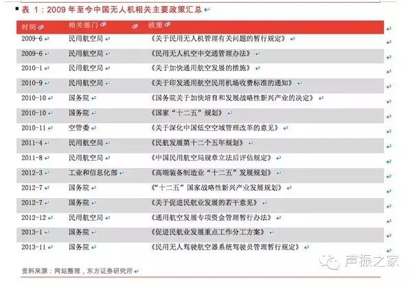
Summary of Major Drone-Related Policies in China from 2009 to Present
In general, before 2009, drones were in an unregulated state. After 2009, they began to enter the licensed flight stage, but the laws, regulations, and regulatory enforcement have yet to be perfected and formalized, and the actual application processes remain ambiguous.
U.S. Drone-Related Policies: The Draft for Commercial Drones is Finally Out
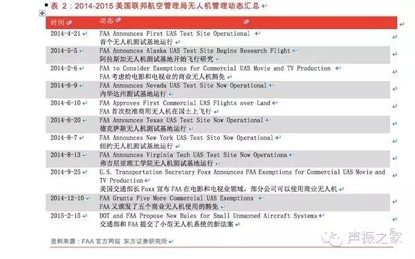
Summary of U.S. Federal Aviation Administration Drone Management Dynamics from 2014 to 2015
After a long wait and multiple delays, on February 15, 2015, the U.S. Federal Aviation Administration finally released the long-awaited draft for commercial drone management. This new regulation breaks the previous comprehensive flight ban, but still awaits final approval.
1
Flight time, altitude, speed, and payload restrictions: It limits drones to fly only during the day, must remain within the operator’s visual range throughout the flight, with a maximum altitude of 150 meters and a maximum speed of 160 kilometers per hour. Drones are not allowed to fly over people or drop objects from the drone, and there are restrictions on attaching packages to the exterior of the drone.
2
Flight route and location restrictions: Drones must avoid aircraft flight paths and restricted flight zones and must strictly adhere to relevant temporary flight restrictions. Drones must stay at least eight kilometers away from manned aircraft airports. Drones must always remain within the visual range of the radio operator during flight.
3
Operator qualification requirements: Drone operators must be at least 17 years old, must obtain a U.S. Federal Aviation Administration drone operator certificate, and must pass the Transportation Security Administration’s screening requirements.
4
Additionally, hobbyist model drones remain unrestricted as long as they do not interfere with air traffic.
UK Drone Policy: The World Leader in Drone Regulations

Summary of Recent Major European Drone Policies
CAP722 is the guidance for drone use issued by the UK Civil Aviation Authority, with the fourth edition of CAP722 released in April 2010, adapting to the introduction of the Air Navigation Act 2009. All regulations regarding drones are now included in the Air Navigation Act 2009. Before that, CAP722 was the reference standard for the industry, widely imitated and implemented worldwide. This document emphasizes safety requirements regarding airworthiness and operational standards that need to be considered before operating drones in the UK. The latest version of CAP722 was released in August 2012, implementing a considerable degree of open policy for civilian drones. The UK Civil Aviation Authority is a leader in drone regulation.
European Regulation 2008 No. 216 governs all drones with a total weight exceeding 150 kilograms. The design and production of drones must also adhere to relevant certification standards, just like conventional aircraft (this standard is led by EuroUSC, which is authorized by the Civil Aviation Authority to implement a light drone program), and must obtain airworthiness certification or permission to fly. In the UK, drones weighing between 20 and 150 kilograms must have airworthiness qualifications under UK law. If an aircraft operates within a radius of 500 meters and below 400 feet, or in isolated flight zones, and the drone meets certain airworthiness guarantees, the UK Civil Aviation Authority may waive the need for airworthiness certification. The UK Civil Aviation Authority will also issue waivers based on its investigations and recommendations; currently, only one organization has received this permission. Drones weighing less than 20 kilograms are not subject to many major policy requirements, but the Air Navigation Act No. 98 has established certain conditions. These conditions include prohibiting flights in controlled airspace or near airports unless permission is obtained from air traffic control, a maximum altitude of 400 feet, and prohibiting high-altitude operations without special permission from the UK Civil Aviation Authority.
Currently, operating drones under UK aviation law does not require a certified pilot’s license. However, the UK Civil Aviation Authority requires all potential drone operators to possess flight qualifications. Flight qualifications can be obtained by completing designated courses, and four accredited organizations operate training and examination.
4. Global Drone Market
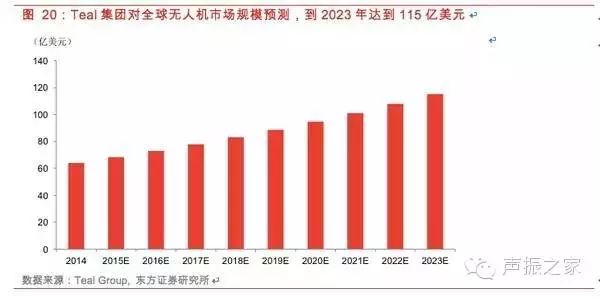
The above chart is a forecast from Teal Group regarding the global drone market scale, which estimates that the drone market will reach $11.5 billion by 2023.
As for the market share between military and civilian, Teal Group provides a more optimistic view of the civilian market (with an approximate annual compound growth rate of 9%, reaching $1.5 billion by 2023). Of course, Teal Group specifically mentions that high-tech giants such as Google, Facebook, and Amazon bring potential disruptive changes to the civilian and military drone industries that are currently difficult to quantify.
We believe that the explosive growth of the civilian drone market globally requires overcoming two bottlenecks: airspace resources and safety issues. Once these two problems are resolved worldwide, the imagination of humanity using drones to conquer airspace will be completely opened up, and the global civilian drone market may experience explosive growth.
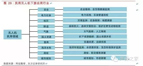
Downstream Applications of Civilian Drones
1Civilian Drones: Broad Downstream Demand, Entering a Rapid Development Period
The downstream demand for civilian drones is very broad, including agriculture, electricity and oil, disaster inspection, forestry, meteorology, land resources, police, marine water conservancy, surveying and mapping, urban planning, and more. In recent years, the application of drones in the civilian market has received increasing attention, especially in agricultural protection and power line inspection, where demand is urgent and market scale is large. We believe that potential demand in other industries will gradually emerge, and China’s civilian drone market has vast potential and will enter a rapid development period.
Agricultural Protection: The largest market for civilian drones, with the agricultural protection market scale exceeding 10 billion
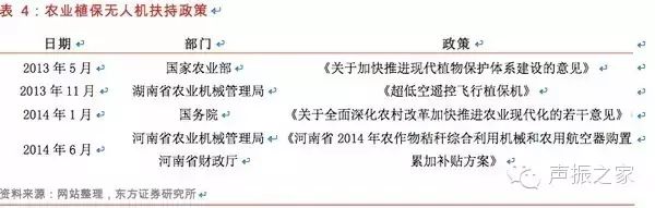
Support Policies for Agricultural Protection Drones
Japan has been using agricultural protection drones for over 20 years, with an annual renewal amount of about 3,000 units. Based on the annual pesticide usage in China and Japan, if China reaches Japan’s current level of agricultural protection drone penetration and usage frequency, the annual renewal amount could reach about 30,000 units, with an estimated market scale of 15 billion yuan based on a price of 500,000 yuan per unit.
Power Line Inspection: Policies are expected to be introduced, with a market scale exceeding 1 billion
In January 2009, the State Grid Corporation of China officially launched the development of an unmanned helicopter inspection system.
In March 2013, the State Grid Corporation of China issued the “Pilot Work Plan for Helicopter, Drone, and Manual Collaborative Inspection Modes for Transmission Lines.” The plan pointed out that establishing a new inspection model that integrates helicopter, drone, and manual inspections is an urgent need for the development of a strong intelligent grid. Currently, the company’s helicopter inspection operations are gradually developing towards standardization and institutionalization. To this end, the company selected ten inspection companies in Shandong, Hebei, Shanxi, Hubei, Sichuan, Chongqing, Zhejiang, Fujian, Liaoning, and Qinghai as pilot units, and plans to carry out pilot work for the new inspection model over 2-3 years. By 2015, the State Grid Corporation’s system will fully promote the new inspection model that integrates helicopter, drone, and manual inspections for transmission lines.
In June 2014, the Standardization Center of the China Electricity Council publicly solicited opinions on the draft of the “Technical Guidelines for Drone Inspection Operations on Overhead Transmission Lines.” We expect that the drone industry standards from the Electricity Council will be officially introduced this year.
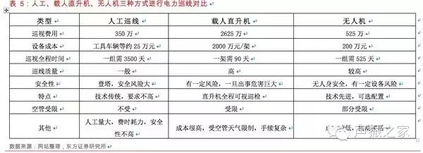
Comparison of Inspection Methods Using Manual, Manned Helicopters, and Drones
China has approximately 52,000 kilometers of high-voltage transmission lines above 110kV. Based on an annual inspection frequency of 30 times, the total inspection length is approximately 15.6 million kilometers. Drones can inspect 20 kilometers per hour, and assuming each drone flies for 150 hours a year, about 5,200 drones are needed nationwide. Assuming a cost of 200,000 yuan per drone, the annual market space is approximately 1.04 billion yuan.
Forest Fire Prevention: Urgent Demand, Still in the Initial Stage
China has a forest area of 175 million hectares, with a forest stock of 12.456 billion cubic meters and a forest coverage rate of 18.21%. It is both a major forest resource country and a country prone to forest fires.
Currently, many new technologies and devices have been applied abroad for forest fire prevention, and domestic demand for such applications is increasing, with investments in forest protection gradually increasing. Satellite technology has been used for resource surveys and forest fire monitoring, but the use of drone systems for forest fire monitoring is still in its initial stage.
Disaster Inspection: National Needs, Vast Space
The Wenchuan earthquake in 2008 caused numerous secondary geological disasters such as landslides, mudslides, and dammed lakes, severely damaging most national highways, provincial roads, and rural roads in the disaster area, making disaster relief work extremely difficult. Due to weather factors, satellite remote sensing systems or manned aerial remote sensing systems struggle to obtain real-time ground images of the disaster area. After the earthquake, various models of drone aerial remote sensing systems rapidly entered the disaster area, widely used in disaster assessment, landslide monitoring, damage assessments of buildings and roads, disaster relief evaluations, and recovery and reconstruction, achieving excellent results and fulfilling roles that other means cannot replace. The aerial remote sensing system of drones was successfully used for emergency disaster relief for the first time.
During the 2013 Ya’an earthquake rescue operation, the National Earthquake Disaster Emergency Rescue Team used rotary-wing drones to conduct aerial inspections of the terrain and damage in the disaster area, providing reference and basis for the rescue work of the National Earthquake Disaster Emergency Rescue Team. This drone was developed jointly by the National Earthquake Disaster Emergency Rescue Team and the Shenyang Institute of Automation, Chinese Academy of Sciences, with a detection accuracy of 0.1 meters and the capability to fly continuously for 100 kilometers at low altitudes of 200 meters.
China experiences frequent natural disasters, causing significant losses annually. To improve disaster response efficiency and quality, timely and accurate disaster information must be provided. Conventional disaster monitoring methods have long cycles, high costs, and struggle to meet emergency response needs. The drone aerial remote sensing system, as a supplement to satellite and manned aerial remote sensing, has advantages such as strong real-time capabilities, flexibility, minimal external environmental impact, and low costs, offering broad development space and application prospects in disaster emergency response.
2The Consumer Drone Market is Rapidly Heating Up
This year, the global drone market has received widespread attention, with DJI’s innovative products coming to the forefront, while domestic companies like XAG Technology, Zero Tech, and foreign companies like 3DRobotics are constantly launching products and financing activities. 2015 can be considered the inaugural year for consumer drones.
DJI is a leading small drone manufacturer, accounting for approximately 50% of the global market share for civilian small drones, with 80% of its products sold abroad. It is regarded in Silicon Valley as a world-class drone company comparable to Apple. Established in 2006, DJI initially entered the market with controllers installed on drones, later discovering the market for aerial photography with unmanned aerial vehicles, transitioning to complete systems and stable flight platforms, and now focusing on providing comprehensive aerial imaging strategies. In just a few years, it has grown exponentially, with revenue reaching 800 million yuan in 2013, and was recognized by TIME magazine as one of the top ten innovative tools globally in 2014.
DJI drones are widely used in aerial photography and are favored by both professional and amateur photographers. Its product line includes mid-range Phantom series and the absolute high-end leader Inspire series. Aerial photography shots have appeared in popular TV shows like “Where Are We Going, Dad?” and in popular American dramas like “Agents of S.H.I.E.L.D.” and “Homeland.” Users have also employed them for panoramic scanning of the Christ the Redeemer statue in Rio de Janeiro, close-up shots of whales surfacing, and flying over erupting volcanoes like the Isula volcano.
In addition to DJI, the interest of technology companies in drones has rapidly increased in recent years. Drones are not just “toys” for aerial photography but are seen as disruptive robots for the future: Amazon’s PrimeAir human-machine logistics plan is now in its ninth generation of development; Google acquired drone company Titan Aerospace for network coverage; Facebook also acquired UK drone company Ascenta for $20 million; 3DRobotics has secured $50 million in investments led by its own efforts; and Matternet is building a drone network to deliver food and medical supplies to remote rural areas globally.
The domestic drone market is also gradually emerging, with companies like DJI, Zero Tech, XAG Technology, Yihang UAV, and Tianxiang UAV springing up. On January 20, 2015, Rapoo Technology and Zero Tech jointly established a joint venture to develop drones, and on February 1, 2015, they launched the ZERO consumer-grade quadrotor drone series, which began pre-sales on Zero Tech’s official website and some e-commerce platforms, starting at 3,199 yuan.
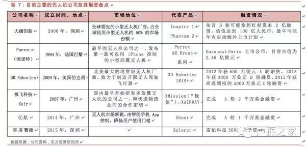
Current Major Drone Companies and Their Financing Overview
Currently, drones are mainly applied in aerial photography and various industry applications, including border defense and agriculture, for example, DJI primarily focuses on aerial photography, while XAG Technology is used across various industries. Additionally, security applications such as search and rescue and theft prevention are also in their infancy. Attempts to use drones for logistics are increasing, with Amazon having developed its program for years, and domestic express delivery companies beginning to test the waters.
Google’s Project Loon aims to create a stratospheric balloon network worldwide, and it also acquired Titan Aerospace to provide solar-powered drones, both of which can provide low-cost internet access anywhere on the planet.
NASA is also developing a “Low Altitude Traffic Management System” for drones, expected to be used in agriculture in 2015. Drone manufacturer Skycatch mainly focuses on data collection for construction, mining, solar energy, and agriculture, and has previously secured $13.2 million in funding. Other innovative applications include bee-sized drones for pollinating flowers, etc.
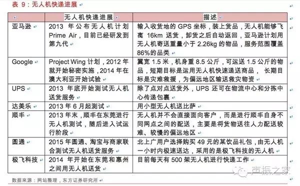
Consumer Applications of Drones Overview
GoPro also joined the “small drone alliance” last year and has launched video camera equipment for several drone models, announcing its entry into the consumer drone market, with the first multi-motor drone expected to be launched this year, priced between $500 and $1,000. DJI has also announced that it will use self-developed cameras in future drone products. The combination of drones with action cameras will be an important application of drones in personalized aerial photography in fields such as sports and health. For instance, STELLA launched a stabilizing gimbal designed specifically for GoPro Hero3 series cameras.
Drones can be used in conjunction with Oculus Rift to provide virtual reality and augmented reality experiences. For example, Parrot launched a wireless controller accessory called Skycontroller, which connects to Oculus Rift via HDMI, allowing direct control of the aircraft’s flight trajectory using directional buttons. This connection method brings human perception into another real space. Such experiences may also be applied in tunnels, canyons, and underwater scenarios in the future, allowing explorers to gain thrilling sensory experiences without needing to physically experience it. More importantly, they won’t need to expend manpower and resources to model and create a virtual world; any location can become a new playground.
According to DJI’s revenue scale of about 3 billion yuan last year and pricing ranging from thousands to tens of thousands of yuan, drone shipments may only be in the hundreds of thousands, indicating immense future growth potential. According to Teal Group statistics, the global civilian drone market reached $2.8 billion in 2014, with unprecedented continuous growth expected over the next decade, and the market scale is projected to more than double.
5. In the Future, What Can Drones Do for Us?
In addition to the military, commercial, and consumer functions we are already familiar with, drones capable of “going to the sky and into the ground” may bring infinite surprises to our lives in the future. At an altitude of 300 meters, free from ground congestion and various restrictions, drones in the future will not only play the roles of super delivery personnel and super police but can also provide low-cost, highly mobile wireless network coverage for the ground. Imagine drones as “flying sensors,” they will become an aerial data port for Industry 4.0, collecting everything from geophysical, meteorological, and agricultural data to personal location information, triggering a revolution of aerial big data!
1Aerial Data Ports for Industry 4.0
We believe that as a “flying sensor,” the most imaginative application of drones in the civilian field may be serving as aerial data ports, providing more precise and powerful data streams for the global Industry 4.0 “big data” system.
Starting with the most common inspection function, using drones to patrol farmland nationwide can observe crop growth, natural disasters, soil changes, and other information more clearly than satellite images. Drones can link data to the global internet, transmitting collected data in real-time to commodity analysts to assess trends in global agricultural futures markets; in the future precision agriculture system, small drones can be used to monitor whether crops lack water and feedback information to irrigation systems to adjust water supply.
From the perspective of personal information data acquisition, drones can simulate WiFi hotspots, sniffing mobile devices’ MAC addresses and triangulating devices based on signal strength, compiling the information to create user movement maps, showing the neighborhoods and stores they typically pass by, allowing for targeted promotional information to be sent to potential consumers who “pass by without entering.” By tracking personal movement trajectories, manufacturers can gain more comprehensive insights into people’s living habits, providing more precise reference data. Additionally, in emergencies, drones can locate individuals by detecting Wi-Fi signals from their mobile devices to save lives.
This technology has some similarities to indoor mobile device positioning technologies like iBeacon commonly used in shopping malls and supermarkets, which can push promotional information when users pass by. The difference is that drones are more flexible and can locate users in more complex geographical conditions.
2Tech Giants’ Next Stop: Providing Flexible, Mobile, Low-Cost Wi-Fi Network Access
With nearly four billion people worldwide still without internet access, solving the internet access problem, such as Wi-Fi network deployment, has become one of humanity’s top ten challenges. Drones, with their low energy consumption and long flight times, can provide internet access services for a larger user base. Additionally, drones have strong maneuverability, allowing them to provide internet access services based on specific needs in certain areas.
Google acquired Titan to seize the internet coverage market: In April 2014, Google acquired drone company Titan Aerospace. Titan Aerospace, founded in 2012, aims to replace high-cost near-Earth satellites with its drones. It has successfully developed and begun testing the Solara 50 and 60 drones, which can sustain flight in near-Earth orbit for five years without landing using solar energy. The Solara drone is 50 meters wide, can carry 32 kg, and can provide network access of up to 1 GB per second through special equipment.
It is reported that after the acquisition, Titan Aerospace will collaborate with two of Google’s projects, one of which is Project Loon, which provides internet services via high-altitude helium balloons. Additionally, Google plans to invest $1 billion to provide internet coverage via satellites. With a three-pronged approach of balloons, drones, and satellites, along with the wired fiber optic access of Google Fiber in urban areas, it is evident how much Google values internet access.
However, wired access improves service quality in already covered areas, while the first three wireless access methods mainly address coverage issues. Relative to that, drone technology may have advantages over balloons, as Titan Aerospace’s drones are powered by solar energy, allowing for endurance of up to a year, while balloon deployment costs are high and maintenance is relatively difficult. Furthermore, drones fly at altitudes higher than commercial aircraft but lower than satellites, allowing them to provide stable high-speed access of 1 Gbps. Therefore, Google’s drones may provide high-capacity services in small areas, while satellites will ensure coverage in low-speed demand areas.
Facebook aims to connect the next billion users in remote areas using drones
Facebook established the Connectivity Lab, whose mission is to develop various internet connection technologies, including satellites and drones. Facebook has also acquired another drone manufacturer, Ascenta, for $20 million, which develops solar-powered drones capable of flying at 20 km high for up to a month. Facebook’s involvement in drones primarily aims to provide internet services to residents in remote areas, attempting to win the next billion users.
3Flying Delivery Personnel
The most famous delivery service using drones is Amazon’s Prime Air logistics plan. At the end of 2013, Amazon announced an eight-wing drone called Prime Air, capable of transporting packages weighing up to five pounds. Amazon is still committed to the shopping sector, providing users with endless choices, the lowest prices, and the promise of future immediate delivery. Amazon’s Prime Air has now entered its ninth generation, capable of carrying five-pound packages, covering 86% of product categories, and flying at speeds exceeding 50 miles per hour. It has officially applied to the FAA for larger outdoor flight tests. Additionally, Google, UPS, and others have also begun testing drone delivery since 2012-2013.
Progress in Drone Delivery
With the introduction of high-performance drones priced in the thousands, drone delivery can significantly reduce logistics costs for the “last mile”:
Energy consumption per order is less than 0.1 yuan – assuming a load of 2 kilograms, the direct hardware cost (mainly energy consumption) for a package within a 10km range is less than 0.1 yuan, with an energy consumption of about 10Ah, less than 40Wh, costing approximately 0.03 yuan;
Drone amortization cost – assuming a drone costs 5,000 yuan, with a five-year operational lifespan and a 20% annual maintenance fee, the total cost is about 6,000 yuan, or about 4 yuan per day. If each drone completes ten tasks daily, this means an amortization cost of 0.4 yuan per package;
In total, the cost per order is less than 0.5 yuan, which significantly reduces logistics costs compared to current manual logistics costs, indicating clear economic benefits for drone delivery.
The most challenging aspect of drone logistics is the final delivery phase. Knowing only the GPS coordinates of the destination is far from sufficient. Currently, methods in Australia involve adding cameras to drones and placing large boxes with specific markings on users’ balconies, allowing drones to identify and accurately deliver packages to users’ balconies through machine vision.
Additionally, regulations remain the biggest obstacle. Recently, the U.S. Federal Aviation Administration (FAA) released a new draft for managing drones,
In the proposed new rules by the FAA, drones must remain within the operator’s visual range. This primarily restricts commercial drones from being used for photography, surveying, search and rescue, and crop monitoring, which is unfavorable for drone delivery services.
4Personal Safety Aerial Guardians
Drones have various functions such as logistics delivery, information monitoring, and aerial photography. Will the birth of drones capable of recording our daily lives soon become a reality? Perhaps in the near future, it will be possible. The “Mind4” quad-rotor drone developed by AirMind in Shanghai has been dubbed the “Tracker Drone” because it can track a specified person or target and photograph it.
The design concept of “Mind4” is to document our lives, even recording non-human organisms. The camera equipped on it can cover distances beyond 20 meters from the specified object. With its automatic navigation function, the maximum height when tracking a selected target can reach 20 meters, and the furthest distance behind can reach 50 meters. Moreover, it can be controlled through gestures.
Quad-rotor drones equipped with built-in cameras have become widely popular, but most still require remote control. GPS-based tracking technology cannot ensure the accuracy of the object’s position (i.e., the camera’s direction) because civilian GPS is usually imprecise.
Considering the rapid development of civilian drone products over the years, the emergence of products like “Mind4” may no longer be surprising. More mature drones capable of tracking and recording designated targets may provide comprehensive monitoring and protection for personal safety. Imagine in the future, when your child goes to school or plays, a fleet of drones will be ready to track and scan for dangers, ensuring their safety.
The above images and text are sourced from 36Kr, author: She Weichao, reprinted from General Aviation Home

The Most Advanced Drones in the World
From the Iranian capture of the U.S. RQ-170 “Sentinel” drone to the high-profile announcement of its successful replication and first flight; from the dramatic portrayal of the U.S. X-47B drone’s carrier-based takeoff and landing videos to the publicized development progress of the SR-72 hypersonic drone; from Amazon’s drone delivery business to the White House being “attacked” by drones…
As advanced flight technology, sensor technology, navigation control technology, and measurement and information transmission technology continue to emerge, the dominance of drone systems is gradually being broken, and a new norm of “a hundred flowers blooming and a hundred boats competing” will characterize the development of drones worldwide. Below, we will take a look at some of the most advanced drones in the world.
“X-47B” Drone
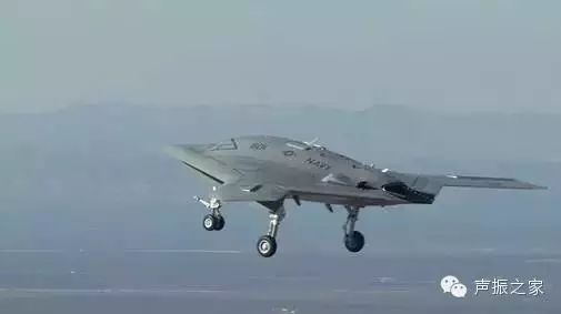
The X-47B is quite large and can be considered a light fighter.
The X-47B drone is the world’s first “hunter-killer” drone that can be used on both land and carriers, featuring high stealth capabilities. This drone, manufactured in the U.S., can carry various reconnaissance payloads and weapons, with a maximum takeoff weight exceeding 20 tons and capable of carrying 2,000 kilograms of ammunition. With aerial refueling capabilities, its operational radius can reach 3,900 kilometers, with an endurance time of up to 30 hours.
“Global Hawk” Drone
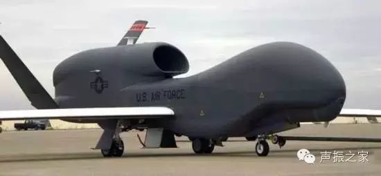
The “Global Hawk” drone is a typical representative of high-altitude, long-endurance multi-purpose drones. This drone has a maximum takeoff weight of 14,628 kilograms, an effective payload of 1,360 kilograms, a maximum flight altitude of 18,300 meters, a maximum range of 22,780 kilometers, and an endurance time of 41 hours, capable of conducting all-weather, all-time uninterrupted reconnaissance over enemy areas.
“Reaper” Drone
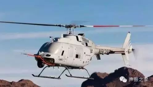
The “Reaper” drone is an upgraded version of the “Predator” drone, which possesses both reconnaissance and real-time strike capabilities. This drone uses a 662 kW turboprop engine and is equipped with seven weapon mounts, capable of carrying 14 “Hellfire” missiles, significantly exceeding the “Predator” drone in takeoff weight, flight speed, and payload capacity.
“Heron” Drone
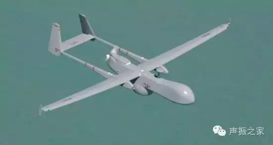
“Heron” drone is a typical representative of large strategic drones from Israel, mainly used for intelligence reconnaissance, communication relay, electronic reconnaissance, and jamming tasks. The latest model of the “Heron” drone has a practical ceiling of 12,000 meters, an effective payload of 1,000 kilograms, and an endurance time of 36 hours, with all-weather operational capabilities.
“Neuron” Drone
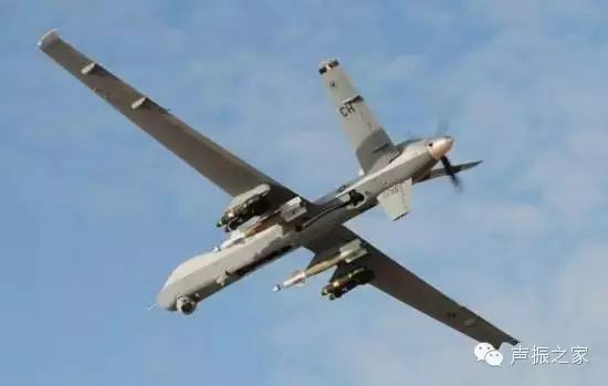
The “Neuron” drone is developed collaboratively by multiple European countries. This drone has stealth capabilities similar to the X-47B, can perform autonomous aerial formation flying, and has the ability to autonomously capture and identify targets. It can carry two 450-kilogram guided bombs and execute missions under the command of fighter pilots.
“Taranis” Drone
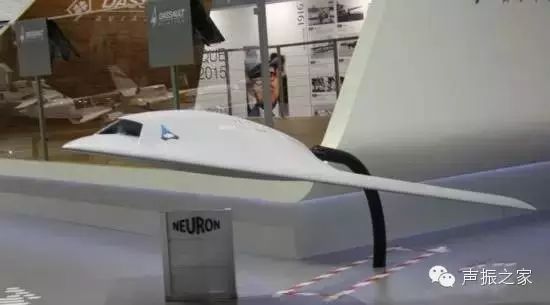
In July 2010, the first high-tech stealth unmanned aircraft prototype from BAE Systems in the UK was unveiled, named “Taranis.” This drone can conduct intercontinental long-range strikes, and its formidable “futuristic” appearance resembles the aircraft from the movie “Star Wars.”
According to reports, “Taranis” is equipped with stealth technology, making it nearly undetectable by ground radar. Its autonomous artificial intelligence systems and recognition systems allow it to conduct surveillance and reconnaissance on enemy targets. The drone is equipped with missiles and other weapons, capable of long-range attacks. “Taranis” is designed for high-speed intercontinental flights, capable of reaching any corner of the Earth under satellite monitoring.
“RQ-7” Shadow Drone
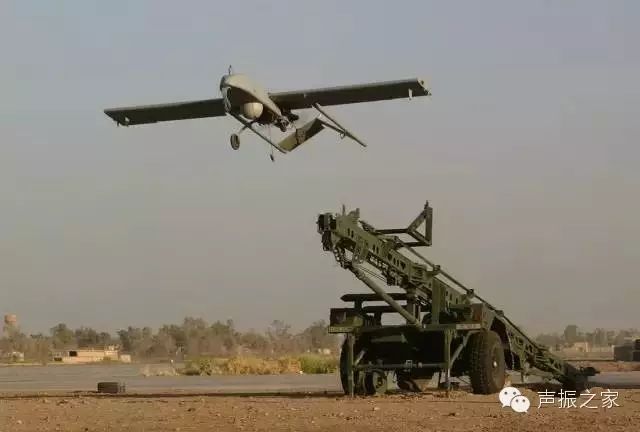
The RQ-7 Shadow drone is the latest drone system in the “Shadow” series, known as the “eyes of the army,” enabling army commanders to “discover first, understand first, and act first” in combat.
The RQ-7 can detect targets up to 125 kilometers away from the army brigade tactical operations center and can conduct all-weather reconnaissance of ground tactical vehicles within a 3.5-kilometer inclined distance at an altitude of 8,000 feet; the “Shadow” ground control station can transmit images and remote sensing survey data to the E-8 “Joint Stars” aircraft, the All-Source Analysis System (ASAS), and the army’s battlefield artillery target tracking and guidance systems in near real-time.
The RQ-7 can also provide near real-time target location data for precision weapons; the RQ-7 drone system is small and lightweight, allowing three units to be deployed to any combat zone using a C-130 transport aircraft.
“Rainbow-4” Drone
The Rainbow-4 drone mid-range drone system comprises a mid-range drone, a ground vehicle-mounted telemetry and remote control station, and ground support equipment. It has a maximum range of 3,500 kilometers and can cruise for up to 40 hours without refueling.
This aircraft is equipped with photographic and video devices, SAR radar, and communication equipment, allowing it to conduct not only conventional reconnaissance but also to carry precision-guided weapons for accurate strikes on fixed and low-mobility ground targets.
Military-grade drones each have their own characteristics and advantages, with the most significant being technological innovation. Currently, the consumer drone industry is also vibrant, but very few companies possess their core technologies. Apart from established enterprises like DJI, which have been developing for ten years, there are many startup companies like TopXGun that persist in technological innovation, while many others still play the role of assemblers or OEMs.
The above information is referenced from the PLA Daily, Drones
Smartbird, the German Machine Bird
Many machines can fly – but none can fly like a real bird. Until… Markus Fischer and his team created Smartbird: a bionic seagull that relies on flapping its wings to achieve flight.
The German technology company Festo’s scientists invented a machine bird called SmartBird, which can autonomously start, fly, and land, with agility comparable to that of a real bird.
Friendly Reminder, it is recommended to enjoy under Wi-Fi
Its wings not only flap up and down but can also twist at certain angles, making this extremely lightweight “bird” highly aerodynamic and very flexible.
Friendly Reminder, it is recommended to enjoy under Wi-Fi
It can glide autonomously in the sky and change direction by swinging its tail and head. Its minimal materials and lightweight structure minimize resource and energy consumption.
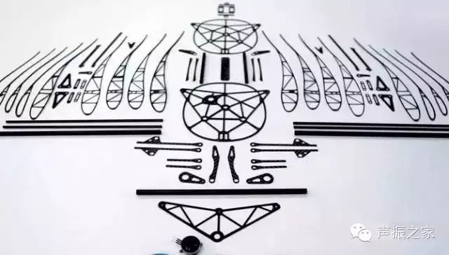
In addition to its technological advances, its appearance resembling a real bird is also astonishing.
SmartBird was developed by German Festo scientists who cracked the flight principles of birds to create a machine bird that not only perfectly simulates bird flight but also looks incredibly realistic, making it hard to distinguish from a real one. The above information is sourced from YouYiSi, Metal Processing
Source: Aviation Micro Reading
For more wonderful content, please check the original text at the bottom
↓↓↓ Click “Read the Original”
Disclaimer: This WeChat reprinted article is for non-commercial educational and research purposes and does not imply endorsement of its views or verification of its content. Copyright belongs to the original author. If the reprinted article involves copyright issues, please contact us immediately, and we will modify or delete related articles to ensure your rights!