The table from the previous article displays correctly on computers, but is incomplete when viewed on mobile devices, so I have taken a screenshot and am reposting it.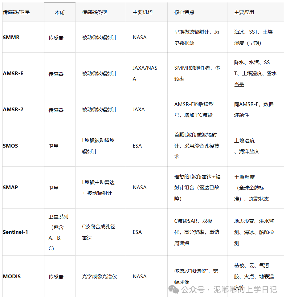 Next, I will introduce the detailed parameters of each type of satellite/sensor.【SMMR】
The full English name of SMMR is Scanning Multichannel Microwave Radiometer.
Agency: NASA
Satellite: Nimbus-7
Type: Passive Microwave Radiometer (historical sensor)
Frequency Bands: 6.6GHz (C band), 10.7GHz (X band), 18GHz (Ku band), 21GHz (K band), 37GHz (Ka band)
Incidence Angle: 50.2°
Spatial Resolution: Approximately 150 km (6.6 GHz) to 30 km (37 GHz)
Operational Period: 1978-1987
Common Bands and Products:
6.6 GHz: Used for soil moisture retrieval (but with limited accuracy).
37 GHz & 18 GHz: Used to generate long-term global sea ice concentration time series, which is one of its most important scientific legacies.
Also used for sea surface temperature (SST) research.
Note: A pioneering multichannel microwave radiometer that laid the foundation for subsequent sensors.
【AMSR-E】
The full English name of AMSR-E is Advanced Microwave Scanning Radiometer for EOS.
Agency: JAXA (development) / NASA (deployment and data processing)
Satellite: NASA Aqua Satellite
Type: Passive Microwave Radiometer
Frequency Bands: 6.9GHz (C band), 10.7GHz (X band), 18.7GHz (Ku band), 23.8GHz (K band), 36.5GHz (Ka band), 89.0GHz (W band)
Incidence Angle: 55.0°
Spatial Resolution: Approximately 56 km (6.9 GHz) to 5 km (89 GHz)
Operational Period: 2002-2011
Common Bands and Products::
6.9 GHz: Retrieval of soil moisture and ocean water vapor.
36.5 GHz & 18.7 GHz: Retrieval of sea surface temperature (SST), sea surface wind speed, atmospheric water vapor and cloud liquid water.
36.5 GHz: Retrieval of precipitation and snow water equivalent.
Note: AMSR-E is the outstanding successor to SMMR, and its high-quality data greatly advanced water cycle research, becoming the core of medium-scale global microwave remote sensing from the 2000s to the early 2010s.
【AMSR-2】
The full English name of AMSR-2 is Advanced Microwave Scanning Radiometer 2.
Agency: JAXA
Satellite: GCOM-W1 (Shizuku) Satellite
Type: Passive Microwave Radiometer
Frequency Bands: 7.3GHz (C band), 10.65GHz (X band), 18.7GHz (Ku band), 23.8GHz (K band), 36.5GHz (Ka band), 89.0GHz (W band)
Spatial Resolution: Approximately 35 km (7.3 GHz) to 5 km (89 GHz)
Incidence Angle: 55.0°
Operational Period: 2012 to present
Common Bands and Products::
7.3 GHz & 10.65 GHz: Mainly used for retrieval of soil moisture, with its C band (7.3GHz) being less affected by radio frequency interference (RFI) compared to AMSR-E’s C band (6.9GHz).
Other band applications are similar to AMSR-E, used for precipitation, water vapor, sea surface wind fields, sea ice, snow water equivalent, etc.
Note: AMSR-2 is the follow-up mission to AMSR-E, aimed at ensuring the continuity and stability of global water cycle observation data.
【SMOS】
The full English name of SMOS is Soil Moisture and Ocean Salinity.
Agency: ESA (European Space Agency)
Satellite: SMOS Satellite
Type: Passive Microwave Radiometer (L-band two-dimensional synthetic aperture imaging)
Frequency Band: 1.4 GHz (L band)
Spatial Resolution: ~35-50 km
Operational Period: 2009 to present
Incidence Angle: No fixed incidence angle
Common Bands and Products::
L band brightness temperature: This is its only and core frequency, observed at multiple angles.
L2 products: Soil moisture, ocean salinity, vegetation optical depth (VOD).
L3/L4 products: Global gridded soil moisture products.
Note: The world’s first satellite dedicated to measuring soil moisture and ocean salinity. Its innovative synthetic aperture technology (MIRAS) forms two-dimensional images without mechanical scanning.
【SMAP】
The full English name of SMAP is Soil Moisture Active Passive.
Agency: NASA
Satellite: SMAP Satellite
Type: Active-Passive Microwave System (currently only passive operation)
Radar: ~3 km (before failure)
Radiometer: ~36 km
Active Radar:: 1.26 GHz (L band) (failed in July 2015)
Passive Radiometer: 1.41 GHz (L band)
Incidence Angle: 40°
Operational Period: 2015 to present (radiometer operational)
Common Bands and Products::
L band radiometer brightness temperature: Current main data source.
L2/L3 products:: Soil moisture (36km), freeze-thaw state.
(historical)L2 products: Radar/radiometer fused 9km soil moisture products.
Note: Advanced design concept aimed at combining the high resolution of radar and the high accuracy of radiometers. Although the radar has failed, its L band radiometer data remains the gold standard for global soil moisture products due to its excellent calibration and algorithms.
【Sentinel-1】
Agency: ESA (European Space Agency)
Satellite: Sentinel-1A, Sentinel-1B (1B has failed), Sentinel-1C, D (future)
Type: Active Microwave Sensor (C band Synthetic Aperture Radar – SAR)
Frequency: 5.405 GHz (C band)
Polarization Modes:: HH+HV, VV+VH, HH, VV (depending on operational mode)
Spatial Resolution:: 5m x 20m (interferometric wide swath mode)
Operational Period:: 2014 (1A) to present
Common Bands and Products::
C band SAR data: This is its core data source.
L1 products:: Single Look Complex (SLC) data (for InSAR analysis), Ground Range Detected (GRD) data (for classification, change detection).
Application-level products:: Widely used for surface deformation monitoring, flood mapping, sea ice classification, ship detection, oil and gas exploration, etc.
Note: The cornerstone of the European Copernicus program, providing free, open, stable, and periodically updated C band SAR data, revolutionizing the availability and application breadth of SAR data.
【MODIS】
The full English name of MODIS is Moderate Resolution Imaging Spectroradiometer.
Agency: NASA
Satellite: Terra (EOS AM-1) and Aqua (EOS PM-1)
Type: Optical Imaging Spectrometer
Bands: 36 spectral bands (0.4 μm – 14.4 μm)
Spatial Resolution: 250m (bands 1-2), 500m (bands 3-7), 1000m (bands 8-36)
Operational Period: 1999 (Terra) and 2002 (Aqua) to present
Common Bands and Products::
Bands 1-2 (Red, Near Infrared): Used to calculate NDVI, EVI.
Bands 3-7: Used for cloud, aerosol, fire point monitoring.
Bands 31-32 (Thermal Infrared): Retrieval of land surface temperature (LST).
Products: Covering atmosphere (aerosols, clouds), land (vegetation index, burn scars, land cover, snow cover), ocean (chlorophyll) and hundreds of scientific products.
Note: A milestone sensor in optical remote sensing, its long on-orbit time, global coverage capability, and rich data product library make it one of the most important and widely used data sources in Earth system science research.
Today’s sharing ends here, thank you for watching, and welcome criticism and suggestions.