Development of a High-Precision Monitoring System for Surface Solar Radiation and Remote Sensing Products at Near-Global Scale

Development of a High-Precision Monitoring System for Surface Solar Radiation and Remote Sensing Products at Near-Global Scale

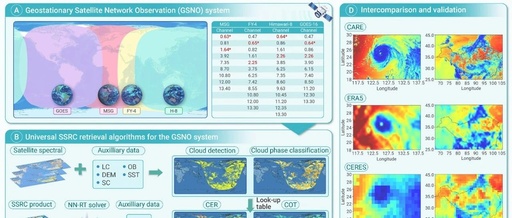
Recently, the National Tibetan Plateau Scientific Data Center, as a data repository for scientific papers, shared the “Near-Global Scale Surface Shortwave Radiation, Photosynthetically Active Radiation, and Ultraviolet Radiation Dataset (2018.6-2019.6)”, developed by Researcher Husi Letu and Researcher Shi Chong (first author) from the Chinese Academy of Sciences’ Aerospace Information Research Institute and their team. This … Read more
Multi-Satellite Network for High-Precision Monitoring: Chinese Scientists Lead the Installation of a “Sunlight Scanner” for Earth

Multi-Satellite Network for High-Precision Monitoring: Chinese Scientists Lead the Installation of a "Sunlight Scanner" for Earth

China News Service, Beijing, March 31 (Reporter Sun Zifa)The solar radiation on the Earth’s surface is the fundamental energy source for life activities on Earth and is also a key factor affecting climate change, agricultural production, and solar energy utilization. Efficient and high-precision monitoring of this radiation has garnered significant attention. Installing a “Sunlight Scanner” … Read more

A Spaceborne Advanced Storage System for Remote Sensing Microsatellites

A Spaceborne Advanced Storage System for Remote Sensing Microsatellites

Content Introduction Abstract: With the development of satellite miniaturization technology and remote sensing technology, the rapid deployment and application of microsatellite constellations is an inevitable trend. Due to the limitations of size, weight, and power (SWaP), onboard storage systems with high scalability, high performance, and high reliability remain one of the technical bottlenecks for remote … Read more

Satellite Platforms in Commercial Aerospace and Satellite Internet

Satellite Platforms in Commercial Aerospace and Satellite Internet

In this issue, we focus on the satellite platforms and payloads for satellite internet. Satellites are mainly divided into three categories based on their purposes or payloads: communication satellites, navigation satellites, and remote sensing satellites. 01 Overview of Satellites (1) Navigation Satellites Satellite navigation is a space-based radio navigation system that uses navigation satellites as … Read more

A Comprehensive Guide to Common ArcMap File Extensions

A Comprehensive Guide to Common ArcMap File Extensions

Are you often confused by the variety of file extensions in ArcMap, constantly screaming “Who am I? Where am I? What am I doing?” Good news for everyone, Renowned Instructor Yan Lei from Zhongke Dixin brings you the most detailed analysis of ArcMap suffixes, be sure to bookmark it! 01 .SHP Shapefile file extension, currently … Read more

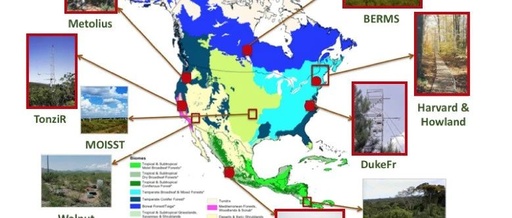
AirMOSS: L2 Hourly In-Ground Soil Moisture Data from 2011-2015

AirMOSS: L2 Hourly In-Ground Soil Moisture Data from 2011-2015

AirMOSS: L2 Hourly In-Ground Soil Moisture at AirMOSS Sites, 2011-2015 The ground sensors (L2) hourly volume (cm³/cm³) soil moisture profile from seven sites in North America. Introduction This dataset provides Level 2 (L2) hourly volume (cm³/cm³) soil moisture profiles collected from ground sensors at seven sites in North America, as part of the Airborne Subcanopy … Read more