Examining the landscape of Northern Henan as depicted by Mr. Bai Meichu, from the agricultural hinterland of Huaxian, the commercial port of Daokou, to the mountainous and perilous terrain of Xunxian, each area has its unique positioning. When turning our attention to Xinxiang, the picture presented in the gazette suddenly transforms: a transportation hub and logistics center rapidly emerging with the power of modern railways. Xinxiang’s role is no longer merely reliant on historical accumulation or natural endowments, but rather the most vivid imprint of the modern transportation system in Northern Henan.
Administrative Evolution
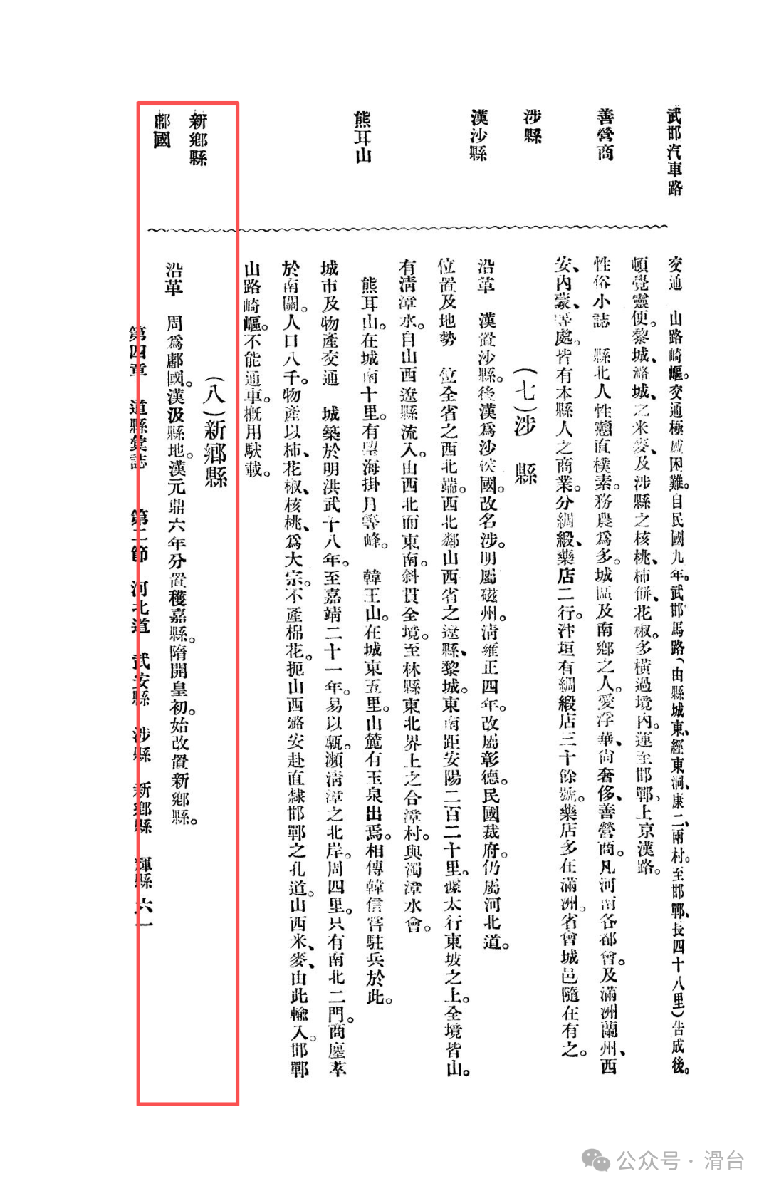
Xinxiang has a profound historical heritage. During the Zhou Dynasty, it belonged to the Yong State, and in the Han Dynasty, it was under the jurisdiction of Jixian. In the sixth year of the Yuan Ding era of Emperor Wu of Han (111 BC), Huo Jia County was established. In the early years of the Kaihuang era of Emperor Wen of Sui (around 581 AD), Xinxiang County was established, a name that has been used to this day. Although its establishment was later than that of surrounding counties, it has since the Sui and Tang Dynasties firmly become an administrative stronghold in the region.
City and Population Overview
The Xinxiang County city recorded in the gazette of the Republic of China has already shown a vigorous vitality due to transportation.
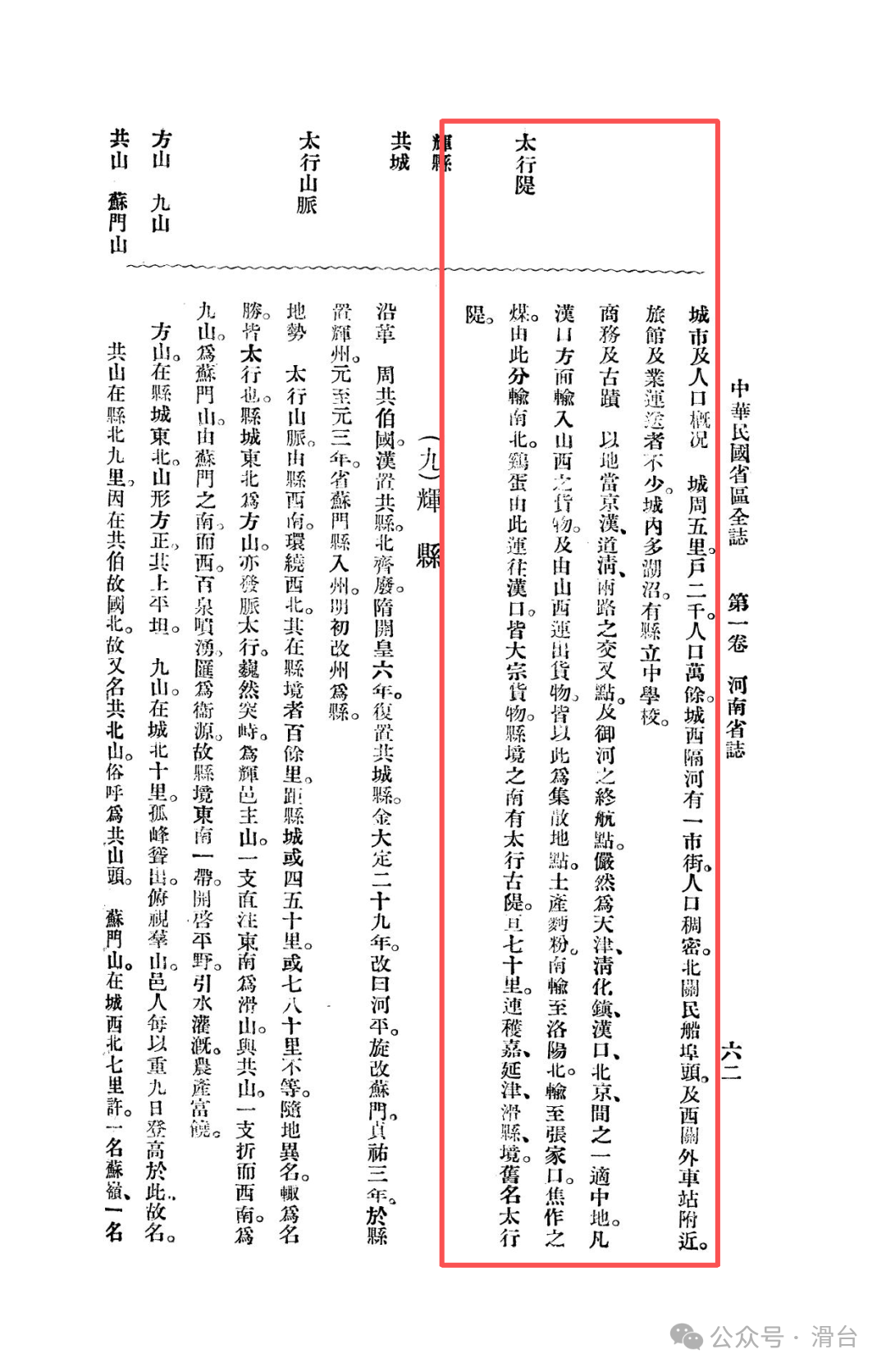
Urban Layout:The county town has a circumference of five li, with a moderate scale. Its notable feature is that a densely populated new street has formed across the Wei River to the west, marking that urban development has broken through traditional city walls and extends naturally along the transportation lines.
Transportation Nodes:Beiguan serves as a passenger ship dock, while the area around the west gate station is filled with numerous hotels and transport operators. The concise records vividly depict the service industry formed around the water and land hub, revealing Xinxiang’s core function as a transfer station for people and goods.
Urban Ecology and Education:There are many lakes and marshes within the city, adding to its scenery. The establishment of the county middle school reflects the emphasis on cultural and educational endeavors.
Population Scale:There are about two thousand households in the city, with a population exceeding ten thousand, whose vitality far exceeds that of an ordinary agricultural county town.
Establishment of the Regional Logistics Center
This section is the core of the gazette’s description and represents Xinxiang’s most prominent value in Northern Henan.
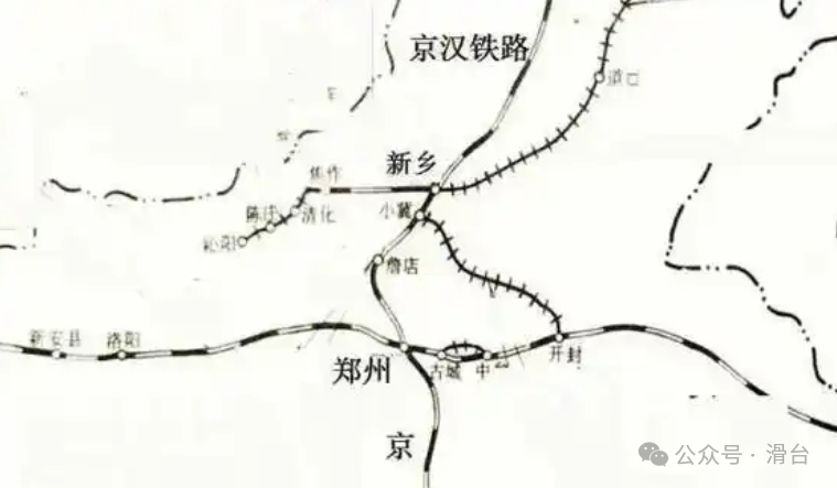
Core Location Advantage:The gazette clearly states that Xinxiang is “located at the intersection of the Jinghan and Daoqing routes, and also serves as the terminal point of the Yu River (Wei River).” This excellent location for water and land intermodal transport makes it a transportation hub between Tianjin, Qinghuazhen (now Boai), Hankou, and Beijing, with a strategic position covering the entire North China trade network.
Core Commercial Function:Xinxiang is indeed the core distribution center for trade between Shanxi and Central and Northern China.
Gateway to Shanxi:“All goods imported from Hankou to Shanxi and those exported from Shanxi are distributed here.”
Major Goods Flow:Local flour is sold south to Luoyang and transported north to Zhangjiakou; coal from Jiaozuo is distributed north and south from here; eggs are concentrated for transport to Hankou. These main goods flow directions clearly mark Xinxiang’s role as a transfer station in the regional economic network.
Integration of Hinterland:Importantly, Xinxiang’s hub position not only serves Shanxi but also deeply integrates the surrounding agricultural hinterland. As mentioned earlier, the agricultural products (wheat, beans, millet, peanuts) from counties like Yanjin mainly flow to “Xinxiang and Jiaozuo.” These products, transported by donkey and horse, converge in Xinxiang’s railway network, subsequently being sent to distant markets. Therefore, Xinxiang is not only a gateway for Shanxi’s exports but also a major distribution center for the entire Northern Henan agricultural region.
Historical Sites and Terrain:
The gazette also does not overlook its natural and historical traces. To the south of the county lies the ancient Taihang embankment, stretching seventy miles, connecting the borders of Huo Jia, Yanjin, and Huaxian, formerly known as the “Taihang Dike.” This ancient geographical barrier silently witnesses the history of the Yellow River’s struggle against floods, forming a dialogue across time with the roaring trains of today.
Mr. Bai Meichu’s depiction of Xinxiang during the Republic of China is that of a burgeoning city filled with modern tension. It has transcended the traditional dual structure of urban and rural (such as Huaxian Daokou Town) and is not inferior to the historical depth and geographical peril (such as Xunxian). Its rise is rooted in the powerful transportation network constructed by the Jinghan and Daoqing railways and the Wei River shipping.
When examining Xinxiang within the panorama of Northern Henan, a clear regional hierarchy system emerges:
Huaxian represents the traditional agricultural foundation;
Daokou Town represents the commercial circulation of the traditional inland shipping era;
Xunxian represents the defensive and cultural functions endowed by history and nature;
Yanjin plays the role of a supporting area for transporting agricultural products to the core hub via land;
And Xinxiang integrates all these functions, emerging as a new generation of regional core city born from modern railway transportation.
Its emergence marks a profound transformation in the economic geography of Northern Henan. Resources and goods flow are no longer solely reliant on the Wei River waterway but are accelerating towards a new economic corridor centered on railways. The donkey and horse teams from Yanjin carrying grain to Xinxiang Station vividly illustrate this historic change. This precious record from nearly a century ago provides the most powerful reference for understanding why Xinxiang has become the hub of Northern Henan today.
Previous Readings:
Memories of Northern Henan in the ‘Comprehensive Gazetteer of the Republic of China’: Yanjin County during the Beiyang Period
Memories of Northern Henan in the ‘Comprehensive Gazetteer of the Republic of China’: Xun County during the Beiyang Period
Memories of Northern Henan in the ‘Comprehensive Gazetteer of the Republic of China’: Huaxian and Daokou Town during the Beiyang Period
From the Battle of Weizhou in 1232, examining why the military system of Huazhou collapsed
Did ancient people also make mistakes in dates? The wisdom behind a “historical error”
Excavated brick inscriptions reveal: the migration and geographical codes of a family settling in Huatai Baima County during the Tang Dynasty
The sleeping eight hundred-year-old Central Plains code: why understanding Huaxian is key to understanding the Northern and Southern Dynasties?
#Xinxiang City #Huaxian Daokou Town #Memories of Northern Henan #Xinxiang Culture #Wei River Shipping #What You Don’t Know About Henan