Abstract:This article re-examines the evolution and geographical significance of the eastern protectorate prefectures under Luzhou during the Tang and Song dynasties based on relevant historical materials, presenting some differing opinions and supplementary evidence.
Keywords: Tang and Song, Luzhou, Protectorate Prefectures, Protectorate Counties
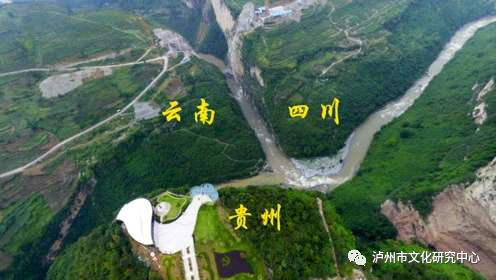
The junction of Sichuan, Guizhou, and Yunnan provinces
In the present-day area where Sichuan, Guizhou, and Yunnan provinces meet, during the Tang and Song dynasties, it was part of the Luzhou Governor’s Office and the Luzhou Southern Border Pacification Office, which successively established more than ten protectorate prefectures, namely the ten prefectures in the western region of Yujing Mountain and the eight prefectures in the eastern region of Naxi Mountain. For instance, the “Song Hui Yao Ji Gao” records in the section on barbarians: “On May 24 of the ninth year of Xining, the acting transport officer of Zizhou, Chen Chen, arranged for the ten prefectures in Luzhou Yujing Mountain and the four prefectures in Naxi, along with the barbarians of Anle and Wudu, to pay taxes and rents, thereby expanding the border.” The so-called “the four prefectures in Naxi and the barbarians of Anle and Wudu” refer to the various eastern prefectures. However, the geographical records of the Tang and Song dynasties regarding their evolution and significance are not sufficiently precise, often leaving later historians at a loss. In the last century, the renowned historical geographer Tan Qiqiang touched upon this issue in his article “Research on the Baizhou Yangbao” (included in the 1987 edition of “Changshui Collection” published by the People’s Publishing House), but the focus remained on verifying the “Luzhou Yi ethnic group” and only listed some materials regarding the geographical significance of each prefecture. The later compiled “Historical Atlas of China” by Tan, which includes the Tang and Song sections, only marked two eastern protectorate prefectures (Ding and Lan prefectures) with fixed points, while the rest remained unmarked, and the fixed points for the protectorate counties were few and far between. In 1998, Dr. Liu Tong, a student of Tan, published a monograph titled “Research on Protectorate Prefectures and Counties in the Tang Dynasty” (Northwest University Press), which also studied the geographical significance of the Luzhou protectorate prefectures, but made little progress on the eastern prefectures and did not address the protectorate counties at all. Based on relevant historical materials, I believe that the studies of Tan and Liu have many points that can be debated and supplemented. Therefore, I have re-examined the evolution and geographical significance of the eastern protectorate prefectures and added evidence regarding the protectorate counties, composing this article. Any inaccuracies are to be corrected.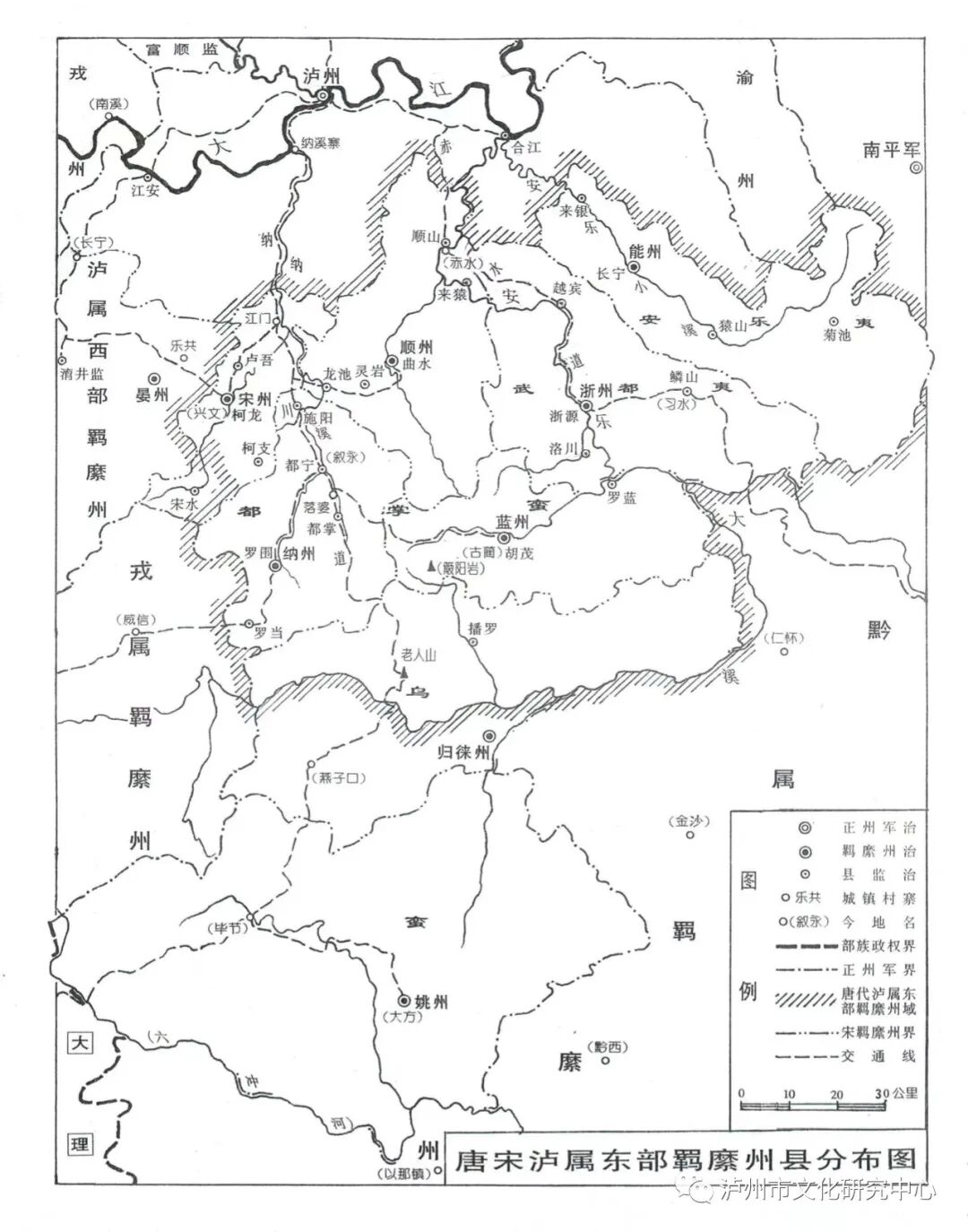 Distribution map of the eastern protectorate prefectures and counties under Luzhou during the Tang and Song dynasties
1. Nanzhou
 Established in the second year of the Tang Yifeng, it was called Duning County in the first year of the Tianbao era, and restored to its former name in the first year of Qianyuan.According to the records in “Tong Dian” Volume 175, “Wu Jing Zong Yao” Volume 19, and “Yuanfeng Nine Domains” (hereinafter referred to as “Yuanfeng Records”), Luzhou is 527 li south to the protectorate Nanzhou Duning County. The Song version of “Geographical Maps of Various Dynasties” places Nanzhou in the southwestern upstream of Naxi (now Yongning River in Xuyong County, Sichuan), thus “Shuzhong Guangji” Volume 16 “Famous Scenic Spots” states: “The Tang protectorate Nanzhou is where the Naxi River originates.” The “Historical Atlas” marks it at the upstream of Yongning River southwest of present-day Xuyong County, which is indeed accurate.The land transportation backbone in the Luzhou area forms a “character” shape, with the apex being present-day Luzhou City, Sichuan. The central north-south transportation line starts from Luzhou, tracing the Yongning River southward, passing through Mani Town in present-day Xuyong County to Bijie County in Guizhou, which Lan Yong refers to as the “Nachuan Road”. Troops from Tang and Nanzhao have traversed this route [1], and it was also the route taken by Lin Guang to suppress the A Yong barbarians during the Song Yuanfeng period (details in the section on Guileizhou below). To reach Nanzhou from Luzhou, one must follow the Nachuan Road, traveling 527 Song li south from Luzhou, which is approximately 151 kilometers today (the conversion rate between Song li and modern measurements is detailed in the section on Songzhou below). This route passes through three locations: Yujin Village in Huangni Township, Nanshankou in Houshan Township, and Dongfeng Village in Jianzhuxiang, Gulin County; however, the latter two have already exited the Naxi River (Yongning River) basin and do not align with the “Geographical Maps of Various Dynasties”, so I believe it is more reasonable to fix the point at Yujin Village in Huangni Township.
Image of “Taiping Huanyu Ji”
Both “Taiping Huanyu Ji” (hereinafter referred to as “Huanyu Ji”) and “Wu Jing Zong Yao” record two different distances for Nanzhou. The former states: “Luzhou southeast to Nanzhou is 450 li.” This actually refers to the distance from the southwestern port of Luzhou, Naxi Zhai (now Anfu Town, Luzhou City) to Nanzhou. The distance from Naxi Zhai to Luzhou is 21 kilometers by land, equivalent to 73 Song li, and the distance from Naxi Zhai to Yujin Village in Huangni Township in Xuyong County is 130 kilometers, equivalent to 454 Song li, rounding to the nearest integer gives 450 li. The latter states: “Nanzhou is 350 li north from Naxi Kou to Luzhou.” This indicates that Naxi Kou is at the southeastern mouth of Yongning River in present-day Xuyong County, marking the northern boundary of Nanzhou.In the Ming Dynasty, some believed that the Duning Post (now Shangluo Township) established 80 li south of present-day Gong County in Sichuan was the Nanzhou of the Tang and Song dynasties, as stated in “Shuzhong Guangji” Volume 36 “Border Defense Records”: “Nanzhou… according to Gong County, there is a Duning Post, which is close to Jianwu.” The “Dushi Fangyu Jiyao” (hereinafter referred to as “Fangyu Jiyao”) Volume 70 “Xuzhou Prefecture” also states: “The abandoned Nanzhou is located 80 li south of the county… The Ming Dynasty initially established Duning Post in Shangluo.” According to the above, Shangluo was under Dingzhou during the Tang Dynasty and under Gongzhou during the Song Dynasty. The Ming people associated the Duning Post in Shangluo with the Tang Nanzhou Duning County, which is not credible.Currently, some believe that Nanzhou is in the old Naxi County (now Anfu Town, Luzhou City) [2]. According to the old Naxi County, during the Song Dynasty, it was Naxi Zhai. The “Yuanfeng Records” states it belonged to Jiang’an County, and “Huanyu Ji” also states that the four prefectures of Naxi, Lan, Shun, and Song “pay half taxes, and their prefectures are in the border areas and do not pay tribute.” Since Naxi Zhai does not belong to the “border areas”, how could it be Nanzhou?As for Liu Tong’s speculation that Nanzhou is in present-day Xingshan County, Sichuan, it is likely due to the misunderstanding that Naxi is within the boundaries of Xingshan County.Nanzhou originally governed eight counties, and its territory approximately corresponds to the southern part of present-day Xuyong County and the central-southern part of Gulin County. Tan Qiqiang believed that Nanzhou “should include the lands of present-day Xuyong and Naxi counties.” According to the northern part of present-day Xuyong County, there is a steep mountain range running east-west, which should serve as the boundary line between the directly governed area of Luzhou and the protectorate area. The old Naxi County is located north of the mountain, which should not be a protectorate area. During the Tang Yuanhe period, the counties of Huma and Luolan in present-day Gulin County were ceded to Lanzhou (details in the section on Lanzhou), leaving six counties remaining. In the Northern Song Dynasty, the southern territory of Nanzhou was also occupied by the Wuman Chele tribe (A Yong barbarians).1. Luowei County Attached to Guo.2. Boluo County Boluo is the alternate translation of “Bo”, and “Luo” means “village” in the Gelao language, so Boluo means “Bo village”. The ancient Gulin County is called “Baiyatohong” in the ancient Yi language, and there is a Boliang Mountain in present-day Manling Township, which is likely its location. Baiya and Boliang are homophones with different translations. To the south of the mountain is the Baisha River, which was likely called Bo River in ancient times, and the mountain to the north was named Boliang due to a phonetic error. The town of Shuangsha in the middle reaches of the Baisha River is likely the ancient Boluo County, which was occupied by the A Yong barbarians during the Northern Song Dynasty and later became part of Guileizhou.3. Shiyang County “Wu Jing Zong Yao” Volume 19 states: “Nanzhou, north from Naxi Kou to Luzhou is 350 li, with Shichi River as the boundary.” The above text indicates that Naxi Kou is in the southeastern part of present-day Xuyong County, so Shichi River is the small river south of Xingshan Township. Shiyang County is named after Shichi River, and according to the principle that “the north of the river is Yang”, it should be located north of the river in Xingshan Township. “Fangyu Jiyao” believes it is in the west of Jiang’an County, which is a major error.4. Duning County The name of the county means “to govern the peace of Duning”. “Huanyu Ji” records: “Luzhou is 320 li south to Duning County of Nanzhou.” This 320 li is equivalent to 92 kilometers, which is the same as the previously quoted “Huanyu Ji” stating that “Luzhou southeast to Nanzhou is 450 li”, both calculated from Naxi Zhai, reaching present-day Xuyong County, which is also the residence of the A Yong barbarian chief in later times, Yongning City. The “Historical Atlas” places Duning County in the territory of Shiyang County, which may be a mistake.5. Duzhang County Both the “New Tang Book: Geographical Records” (hereinafter referred to as “New Tang Records”) and the “Old Tang Book: Geographical Records” (hereinafter referred to as “Old Tang Records”) lack the character “Zhang”; “Huanyu Ji” refers to it as “Luozhang”. The “New Tang Book: Southern Barbarians” states: “At the end of the Shangyuan era, the Nanzhou Liao rebelled, plundering the old Maou and Duzhang counties.” Meng Mo believes: “The so-called ‘Du’ and ‘Luozhang’ should clearly be ‘Duzhang’ due to omission and error.” This is indeed correct, and thus it is corrected. Huma refers to Huma, which was later ceded to Lanzhou, and is located in the area of present-day Gulin County, while Duzhang is close to Duning, located in the area of present-day Xuyong County.6. Luodang County Based on the layout of the various counties in Nanzhou, it is tentatively determined to be in present-day Fen Shui Town, Xuyong County.The abolition of Nanzhou is still recorded in the “Yuanfeng Records”, and the “Geographical Maps of Various Dynasties” also depicts Nanzhou, so it should not have been abolished before the end of the Xining era. The “Song History: Barbarian Records” states that during the Xining era, the Wuman Yanzi and the Fuwang Ge Shu “arbitrarily plundered the six surnames outside Yanzhou Mountain and the twenty-four surnames of Naxi.” The Yanzi tribe is the ancient Yi people of the Mangbu tribe, also known as the Luguo barbarians, who lived in the present-day areas of Weixin and Zhenxiong in Yunnan, and the plundered regions were the prefectures behind Naxi Mountain; the Fuwang Ge Shu and his son Qidi were both leaders of the A Yong barbarians, residing in the present-day areas of Bijie, Xuyong, and Gulin (details in the section on Guileizhou below), and the regions plundered were the prefectures behind Naxi Mountain. Ming scholar Cao Xuequan stated: “The Naxi River originates from the A Yong barbarian tribe, which was the Tang protectorate Nanzhou.” The Naxi River originally belonged to Nanzhou, indicating that Nanzhou had indeed been annexed by the A Yong barbarians. After Qidi’s death, during the Song Dynasty, the A Yong barbarians’ territory was managed by the governor of Yaozhou (the chief of the water west of Guizhou) and soon returned to Qidi’s son A Yong, and the prefectures they annexed, except for Shunzhou, which was re-established as Chunzhu (a proper prefecture) during the Daguan period, were never re-established.2. ZhezhouEstablished in the second year of the Tang Yifeng, the name of the prefecture and the county it governed is recorded as “Zhezhou” and “Zheyuan County” in both “Huanyu Ji” and “Wu Jing Zong Yao”, now based on the two “Tang Records”, “Yuanfeng Records”, “Yudi Jisheng”, and “Song History: Geographical Records” (hereinafter referred to as “Song Records”).
Image of “Yudi Jisheng”
According to its geographical significance, “Huanyu Ji” states: “Neng and Zhe prefectures connect to Qianfu and the Tuozhai barbarians.” “Wu Jing Zong Yao” states: “Zhezhou was established during the Tang Yifeng era, governing Zheyuan County, managing the barbarians in the mountains, with a population of six hundred.” Qianfu refers to the Qianzhou Governor’s Office, and the area where the Luzhou Governor’s Office and the Qianzhou Governor’s Office connect is roughly between the eastern borders of present-day Xishui and Gulin counties and the western borders of Tongzi and Renhuai counties, with the western boundary belonging to Luzhou. The area of Chishui and Xishui counties is referred to as “Naxi Mountain Front”, while the area of Gulin and Xuyong counties is referred to as “Naxi Mountain Back”. Zhezhou is located in the mountain front, likely in the present-day areas of Chishui and Xishui counties. However, “Yudi Jisheng” Volume 166 “Changning Army” states that Zhezhou is located behind Yujing Mountain, belonging to the six barbarian tribes behind Yanzhou Mountain. According to the Song Dynasty, the six barbarian tribes behind Yujing Mountain in Yanzhou were the western protectorate prefectures of Luzhou, namely Xue, Gong, Ding, Gao, Feng, and Yue prefectures, with no Zhezhou, indicating that “Yudi Jisheng” is likely erroneous.Tan Qiqiang in “Research on Baizhou Yangbao” states: “Zhe and Tong are homophones, Zhezhou governs four counties, one of which is Zheyuan, indicating that both the prefecture and county are named after the river, which is the Zhe River, now known as the Zhe River. Another county is called Linshan, and there is an old Ling Mountain in the middle of present-day Zhe County, which may correspond to it.” The “Historical Atlas” marks Zhezhou at the northeastern bank of the Xishui River in present-day Xishui County.In my opinion, the pronunciation of “Zhe” (zhè) is more related to the Zhi River and Zizhou than to Xishui. The Qianlong Le family in the “Huanyu Ji” Luzhou Hejiang County section states: “The Zhi River is winding like the character ‘Zhi’, hence the name.” The “Daming Yitong Zhi” (hereinafter referred to as “Ming Yitong Zhi”) also states: “The Zhi River is located west of Hejiang County, originating from the mountains in Renhuai County, flowing into various rivers.” Therefore, it is known that the name “Zhi River” existed during the Tang and Song dynasties, and it is an alternate name for the Anle River (now the Chishui River) [5]. During the Tang Dynasty, the county governed by Zhezhou was called “Zheyuan”, and the character “Zhe” is a river name, with a pronunciation close to “Zhi” (both “Zhi” and “Zhe” were pronounced with a tongue tip sound in ancient times, belonging to the “Zhao” mother), while it is relatively distant from the pronunciation of “Xi”. It is likely that the people of the Tang Dynasty referred to the Zhi River as “Zhe River”, and the geographical significance of Zheyuan may correspond to the tributary county governed by Song Zizhou, which was later abolished and became the city of Wudu, now the area of Tucheng Town in Xishui County. [6]Zizhou was established in the third year of the Daguan era by the Baizhou Yi people, Yang Guangrong, who offered the land of “Tangzhou Ping” [7]. “Tangzhou Ping” is also known as “Tangzhou Dam”, meaning “the flat land where the Tang Dynasty established the prefecture”, which was said to be located next to the ancient Gulin Prefecture, now in the wide valley area of the Chishui River in the southwest of Xishui County and the eastern part of Gulin County. According to the “Geographical Records of Guizhou Province” (Volume 1), the historical evolution map of Guizhou Province shows that the area southwest of Xishui County was called “Guzhi” in the Yuan Dynasty, which is likely the location of the ancient Zizhou. Furthermore, the geographical connection of Zizhou to Hejiang County and the observation of the Changning Army indicate that the entire prefecture should include the present-day areas of Xishui and Chishui counties, which were the lands of Zhe and Neng prefectures during the Tang and Song dynasties. The name Zizhou likely phonetically resembles “Zhezhou”.From Luzhou to the southeast, there is a land route connecting to the present-day areas of Hejiang and Chishui counties. At the end of the Tang Dynasty, Yang Duan traveled from Luzhou to Baizhou Baizhou (now Zunyi County) via Renhuai, and Zheng Zhen believed that he took the route through Renhuai, while Tan Qiqiang acknowledged that due to the circumstances at the time, he took the Qijiang route, but he also admitted that “following the Chishui River and the Niudu River valley upstream was the most direct route.” This ancient road, which passes through the Chishui River, is tentatively named the “Chishui Road”, with a general direction passing through the present-day areas of Hejiang County, Xishui County, and Zunyi.The exact time of the abolition of Zhezhou is unclear, but from the records of “Wu Jing Zong Yao” and “Yuanfeng Records”, Zhezhou was still observed, indicating that it was not abolished before the Xifeng period. Furthermore, since Zizhou was first established in the third year of the Daguan era, it must not have been later than the early years of Daguan. It is likely that during the Northern Song Dynasty, when the A Yong barbarians annexed the areas behind Naxi Mountain, the protectorate system in the areas in front of Naxi Mountain also lost its order. Tan Qiqiang examined that the ancestor of the Yang family in Baizhou, Yang Duan, was originally a Yi person from Luzhou Hejiang, who entered Baizhou due to military campaigns at the end of the Tang Dynasty. Therefore, the Yang family was originally the chief of Zhezhou, and by the end of the Tang Dynasty, they had developed southeastward and had territories in Baizhou. Before the Song Yuanfeng period, the chief of Zhezhou, Yang, had already moved to Baizhou, hence the record in the “Song Hui Yao Ji Gao” that in the fourth year of Yuanfeng, “the Baizhou Yi Yang Guangzhen” assisted the official army in defeating the A Yong barbarians.The counties, villages, and forts governed by Zizhou are all located in the Chishui River (Anle Daxi) basin. Based on the terrain and transportation routes, it is speculated that many of them were likely established as ancient counties of Zhezhou, which governed four counties, approximately corresponding to the western part of present-day Xishui County and the central part of Chishui County.1. Zheyuan County Attached to Guo. The section of the Chishui River above Tucheng is steep and deep, and the road is impassable, so the Tang people may not have understood the flow direction and mistakenly thought that the area around Tucheng was the source of the Zhe River, thus naming the county. The county seat of Zizhou during the Song Dynasty was in this area.2. Yuebin CountyBased on the geographical situation, it is tentatively determined to be in present-day Yuanhou Town, Chishui County.3. Luochuan CountyBased on the geographical situation, it is tentatively determined to be in present-day Wanglong Town, Chishui County. During the Northern Song Dynasty, Zizhou had a fortress in Laoxi, which is suspected to be in this area. Laoxi is likely Luochuan. The county of Zizhou in Renhuai County is in the western boundary of present-day Luochuan County.4. Linshan CountyTan Qiqiang believes it is in the central part of Xishui County, near Laoling Mountain, which is the area of present-day Xishui County.3. ShunzhouEstablished in the first year of the Tang Zai Chuo era. In the first year of Zai Chuo, the “Old Tang Records” states “three years”, while “Huanyu Ji” states “two years”. According to the first year of Zai Chuo, the ninth month was renamed Tian Shou, and both records are erroneous, now corrected.
Image of “Wu Jing Zong Yao”
According to its geographical significance, “Wu Jing Zong Yao” Volume 19 states: “Shunzhou is located 450 li southeast of Luzhou.” According to the distance of 450 li southeast of Luzhou (approximately 129 kilometers), it can reach three places: one is to trace the Xishui River to the present-day Shibao Township in Chishui County, one is along the Chishui Road to present-day Yuanhou Town in Chishui County, and one is along the Nachuan Road southeast to present-day Huashu Village in Dashi Township, Xuyong County. According to the first two locations, they belong to the Anle Yi (Nengzhou) and Wudu Yi (Zhezhou), while the Shunzhou Yi, as mentioned earlier by Chen Chen, is neither Anle Yi nor Wudu Yi, so the geographical significance of Shunzhou should be taken as Huashu Village in Dashi Township. In the third year of the Song Dynasty, the Yi people Wang Zhongshun established Chunzhu in the area, which is also located in the southwestern part of present-day Hejiang County and the northeastern part of Xuyong County [8], likely established based on the former territory of Shunzhou.Tan Qiqiang in “Research on Baizhou Yangbao” states: “The Chishui River flowing through Chishui County is called Renshui, and Shunren sounds similar. There is still a Shunjiang Market in the southeastern part of the county, which is located on the north bank of the river, indicating that the place is named after the river. The Tang Dynasty established Shunzhou, while during the Song and Ming Dynasties, it was called Renhuai (now Chishui is Renhuai in the Ming Dynasty, and it was moved to its current location during the Kangxi period).” Tan suggests that the city of Chishui County is the seat of Shunzhou, but this city is only 86 kilometers from Luzhou, equivalent to 300 Song li, which is too far from the distance recorded in “Wu Jing Zong Yao”, so it is more accurate to fix it at Huashu Village in Dashi Township, Xuyong County.Shunzhou originally governed five counties, and its territory approximately corresponds to the northeastern part of present-day Xuyong County, the southwestern part of Hejiang County, the northern part of Gulin County, and the western part of Chishui County. The records in “Huanyu Ji” only mention four counties, excluding Longchi County, which was likely abolished by the end of the Tang Dynasty.1. Qu County Attached to Guo. Present-day Huashu Village in Dashi Township, Xuyong County is located along the winding Datong River, which is quite fitting.2. Laiyuan County Present-day Chishui County has large areas of primitive forest, where monkeys used to roam, so the Laiyuan County of Shunzhou should be nearby, likely in present-day Dingzi Township, Hejiang County, where the county seat of Chunzhu was located.3. Shunshan County Present-day Jiuzhi Town is located in a flat area, with fertile fields, and has historically been an important town in the lower reaches of the Chishui River. During the Song Yuanfeng period, it was called Jiuzhi Pond, and in the third year of Daguan, the Yi people established Chunzhu [9], which is also suspected to be one of the former counties of Shunzhou, tentatively identified as Shunshan. The Song Chunzhu had a fortress in Yaoba, which is now in Yao Ba Township, Hejiang County, and was part of the northern boundary of Shunzhou during the Tang Dynasty.4. Lingyan County The “Ming Yitong Zhi” Volume 72 “Yongning Xuanfu Office” states: “Mili City is located 80 li north of the office, with large fields that are always free from drought and flood, and grains mature, hence the name.” This place is in present-day Shuwa Village, Xuyong County, and in the third year of Daguan, a city was established in the territory of Chunzhu, which is likely this location and is also suspected to be one of the county seats under Shunzhou during the Tang Dynasty.5. Longchi County The “Ming Yitong Zhi” Volume 72 “Yongning Xuanfu Office” states: “Tiansheng Pool is located 60 li northwest of the office, surrounded by mountains, and water accumulates in the middle without the need for excavation, hence the name.” This is likely the ancient Longchi, located in present-day Tianchi Town, Xuyong County.According to the “Yudi Jisheng” Volume 166 “Changning Army”, it is recorded that during the end of the Tang Dynasty, the protectorates Neng and Shun were abolished, and based on the records of “Huanyu Ji”, “Wu Jing Zong Yao”, and “Yuanfeng Records”, it is evident that Neng and Shun prefectures were still observed during the early Song Dynasty, and the time of their re-establishment should not be earlier than the Xifeng period, nor later than the early years of Daguan. It is suspected that during the Xifeng period, they were annexed by the A Yong barbarians, and during the Yuanfeng period, Lin Guang defeated the A Yong barbarians, and the land was subsequently occupied by the prominent Wang family of the Yi people.4. NengzhouEstablished in the first year of the Wu Zhou Dazhu era as a territory of the Shengman. According to the earlier quote from Chen Chen, it is known that “the barbarians of Nanzhou, Naxi, and the four prefectures of Shun and Song, along with the barbarians of Anle and Wudu, paid taxes and rents, thereby expanding the border.” Therefore, the barbarians of Anle must be from Nengzhou.
Image of “Yuan Yitong Zhi”
The Anle barbarians are named after the Anle River where they reside. The “Yuan Yitong Zhi” states: “The Anle River originates from the south of Hejiang County, connecting to the Yi boundary, and flows into the river to the north of the county.” The Anle Daxi refers to the present-day Chishui River, while the small river refers to the present-day Xishui River. The Chishui River is where the Wudu barbarians reside, and it was established as Zhezhou, so the Nengzhou where the Anle barbarians reside should be in the Xishui River basin. Although there are no recorded distances for Nengzhou in historical texts, “Huanyu Ji” states: “Neng and Zhe prefectures connect to Qianfu and the Tuozhai barbarians,” indicating that Nengzhou is adjacent to Zhezhou and Qianzhou. If Nengzhou is determined to be in the Xishui River basin, it aligns with this record. The “Historical Atlas” marks Nengzhou’s seat in the eastern part of present-day Chishui County, which is indeed accurate. The major towns in the Xishui River basin include Changsha and Guandu in present-day Chishui County, both of which could be the seat of Nengzhou, but Guandu Town has a long historical significance as a key point in the Xishui River, and the archaeological site discovered there has a group of Song tombs [11]. Therefore, I believe the seat of Nengzhou is more likely to be in Guandu Town.Nengzhou governed four counties, and its territory approximately corresponds to the eastern part of present-day Chishui County and the eastern part of Xishui County. According to “Huanyu Ji”, the counties governed by Nengzhou are Qu County and Ganquan County, but the names of the counties are entirely different from those recorded in the two “Tang Records”, and the county names are all the same as those governed by Shun and Yue prefectures. Since Yuezhou is located behind Yujing Mountain and also belongs to Luzhou, its counties should not have the same names, and although Neng and Shun prefectures are adjacent, the first counties recorded in both prefectures are Qu County, so there should be no issue of ceding counties. A more reasonable explanation is that the counties governed by Nengzhou should still be based on the four counties recorded in the two “Tang Records”: Changning, Laiyin, Juzhi, and Yuanshan. The “Huanyu Ji” based on the “Tujing” could be seen by the authors of the “New Tang Records”, but the authors of the “New Tang Records” rejected the “Tujing”, indicating that they believed the records in the “Tujing” were erroneous.1. Changning County Attached to Guo.2. Laiyin County Present-day Changsha Town in Chishui County is one of the major towns in the Xishui River basin.3. Yuanshan County Located in the deep mountains and forests, where monkeys are likely to be found, suspected to be in the area of present-day Hongqi Township in Xishui County.4. Juzhi County Based on the geographical layout of Nengzhou’s counties, it is tentatively determined to be in present-day Wenshui Town in Xishui County.Nengzhou was abolished at the end of the Tang Dynasty and re-established at the beginning of the Song Dynasty (details in the section on Nengzhou above). Nengzhou and Zhezhou are both located in the mountain front area, and the time and reason for their re-establishment should be the same as that of Zhezhou, indicating that during the Song Dynasty, Zizhou included the former territory of Nengzhou.5. SongzhouAmong the protectorate prefectures under Luzhou, Gao, Song, Changning, and Ding prefectures are not found in the ten prefectures of the “Old Tang Records” but appear in the fourteen prefectures of the “New Tang Records”, with no recorded establishment dates. The “Yuan Zhi” entry for the Ma Lake Road in Rongzhou states: “During the time of Wu Zetian, the barbarians expanded the border and established fourteen prefectures, five groups, and twenty-nine counties, and established Yanzhou in the original territory.” It seems that the fourteen protectorate prefectures under Luzhou recorded in the “New Tang Records” were all established during the time of Wu Zetian. The “Fangyu Jiyao” also states that Luzhou “initially governed fourteen prefectures”. However, upon examination, the “five groups” were not a system of the Tang Dynasty, and Yanzhou was established during the Yifeng era, not during the time of Wu Zetian. Moreover, the “Old Tang Records” data ends in the first year of Qianyuan, which clearly states that at that time, there were only ten protectorate prefectures under Luzhou, so it can be confirmed that it was only possible to increase the establishment of Gao, Song, Changning, and Ding prefectures after the reign of Emperor Suzong. The records in the “Yuan Zhi” and those of Guo are not credible. Furthermore, during the time of Emperor Suzong, military affairs were urgent, and there was no time to increase the establishment of protectorate prefectures, while the Lan Prefecture established during the early years of Emperor Xianzong was not recorded in the “New Tang Records”, so it is speculated that the establishment of these four prefectures in the “New Tang Records” likely occurred during the Zhenyuan era, as the adjacent Rongzhou Governor’s Office also established many protectorate prefectures during the Zhenyuan era. The fourteen protectorate prefectures and fifty-six counties recorded in the “New Tang Records” under Luzhou should reflect the situation at that time, but the number of counties is more than the fifty-four counties mentioned by Fan Bailu in the “Pingyi Ji” during the Song Xining era, which may be due to mistakenly counting the two counties of Fude Prefecture, which had already been ceded to Rongzhou Governor’s Office, as part of Song and Ding prefectures. The geographical significance of Songzhou is relatively clear, located in the original Gucheng Town of present-day Xuyong County, which was incorporated into Xingwen County in 1983 and renamed Zhongcheng Town. There is no disagreement among various sources regarding this. The “Wu Jing Zong Yao” Volume 19 states: “Songzhou is located 350 li southeast of Luzhou.” Zhongcheng Town is 103 kilometers south of Luzhou, equivalent to 359 Song li, rounding to the nearest integer matches the record in “Wu Jing Zong Yao”. This indicates that the conversion rate of distances in the Luzhou protectorate prefecture area during the Song Dynasty is 3.49 Song li = 1 kilometer, which means 1 Song li = 0.2865 kilometers. The distance from Luzhou to Nanzhou recorded in the “Tong Dian”, “Wu Jing Zong Yao”, and “Jiu Yu Zhi” indicates that the conversion rate in the late Tang period in the Luzhou area was the same as this.As for the entry in the “Fangyu Jiyao” Volume 70 regarding Gao County, which states: “Song Water is an abandoned county located in the west of the county… The county has Song Water, and the prefecture and county are likely named after it.” Since Songzhou is a protectorate prefecture located behind Naxi Mountain, and the Ming Dynasty Gao County’s Song Water is located fifty li west of Gao County, the distance and direction are too far apart to conclude that Guo’s statement is based on the name “Song” without further investigation.Songzhou originally governed three counties, and its territory approximately corresponds to the eastern part of present-day Xingwen County and the northern part of Xuyong County, likely established during the Zhenyuan era by separating the lands of Yanzhou and Nanzhou.The “New Tang Records” states that Songzhou has Song Water County, but Song Water County has always been under Fude Prefecture since the Tang Kaiyuan era and has never belonged to Songzhou. After the Song Taiping era, Fude Prefecture was abolished, and it was only then that it came under Songzhou, indicating that the “New Tang Records” mistakenly attributed the situation of the Song Dynasty to the Tang Dynasty.1. Kelong County Attached to Guo.2. Kezhi County Analyzing the geographical layout of the counties in Songzhou, it is likely located in present-day Jinge Township, Xingwen County.3. Luwu County The draft of the “Ancient Song County Chronicle” from the Republic of China Volume 3 states: “Luwu is an abandoned county, and its location is approximately in the area of He Pan Township, Chuanlong Temple, but cannot be specified.” He Pan Township is now in the Hongxing Township of Xingwen County.4. Song Water County Originally belonged to Fude Prefecture, later belonged to Songzhou, and based on the county name, it is likely located in the upstream of Song Water (now known as Guchong River), in the area of present-day Daba Town, Xingwen County. “Huanyu Ji” states that Fude Prefecture is “located 457 li southeast of Rongzhou”, equivalent to 183 kilometers, calculated from the urban area of Yibin City (Rongzhou) through the ancient Heishui Road via Gong County, Xunyang (Dingzhou), Xingwen Xianfeng (Fula County), and Shilin (Keyin County) to Daba (Fude Prefecture), which is 181 kilometers, matching the distance recorded in “Huanyu Ji”.The time and reason for the abolition of Songzhou are the same as those of Nanzhou.6. LanzhouAccording to “Huanyu Ji” Volume 88 “Luzhou”, it states that Lanzhou was established in the second year of the Tang Yifeng, governing Huma County, but both “Tang Records” state that Huma County belongs to Nanzhou and does not record Lanzhou, indicating that Lanzhou was not established during the Yifeng era but should have been established after the reign of Emperor Suzong. The “Fangyu Jiyao” Volume 73 states: “Lanzhou was established in the early years of Yuanhe and abolished in the second year of the Song Qian De, but it is not detailed.” Therefore, it can be inferred that Lanzhou is Lanzhou, established in the second year of Yuanhe, and the record in “Huanyu Ji” stating “the second year of Yifeng” is an error for “the second year of Yuanhe”. Furthermore, according to the Tang administrative division establishment habits, each prefecture generally governs at least two counties, so it is speculated that Nanzhou simultaneously ceded Huma and Luolan counties to establish Lanzhou. The omission of Luolan County in “Huanyu Ji” can only be explained by the origin of the name Lanzhou, which is derived from the name of the newly established prefecture in the Tang Dynasty, which generally preferred to select one or two characters from the names of the counties under its jurisdiction as the name of the prefecture. This is the main reason I propose that Lanzhou is a misnomer for Nengzhou. Qing scholar Yu Jiajun believed that Lanzhou was established during the Tang Dynasty and renamed Lanzhou during the Song Dynasty [12], which contradicts the evolution recorded in “Huanyu Ji”, so I do not accept it. Tan Qiqiang once believed that Lanzhou was Nengzhou: “According to the Tang Records, there is no name for Luzhou and Xuyong, and since Guo’s ‘Jiyao’ has been doubted, I initially did not know that Lanzhou is a phonetic shift of Nengzhou.” However, the “Historical Atlas” places Nengzhou in the eastern part of present-day Chishui County, not in the current territory of Gulin County, indicating that he later modified his viewpoint.Regarding the geographical significance of Lanzhou, “Wu Jing Zong Yao” Volume 19 states: “Lanzhou is located 600 li southeast of Luzhou.” Six hundred Song li is equivalent to 172 kilometers. The “Ming Yitong Zhi” Volume 72 also states: “The Yongning Pacification Office is 250 li east to the boundary of Baizhou… The old Lanzhou is located 180 li east of the office, established in the early years of the Tang Dynasty, with a stele at Tangzhou Dam, which is now eroded.” Although the records are not in Song li, the distance from the boundary of Baizhou (now the bank of the Chishui River in present-day Gulin County, 100 kilometers from Xuyong County) can be inferred that the old Lanzhou is located in the ancient Gulin County (60 kilometers from Xuyong County), which is 174 kilometers from Luzhou City, matching the distance from Luzhou to Lanzhou during the Song Dynasty. Tangzhou Dam refers to the wide valley area mentioned in the Zhezhou section above, which is near the ancient Gulin County, so the “Fangyu Jiyao” states that the abolition of Lanzhou is “there is a place called Tangzhou Dam nearby”. The “Historical Atlas” marks Lanzhou at Tongmin Town in Xishui County, likely due to the assumption that Lanzhou must be near Tangzhou Dam.Lanzhou governed two counties, and its territory approximately corresponds to the southwestern corner of present-day Xishui County and the central-western part of Gulin County.1. Huma County Attached to Guo.2. Luolan County Based on the geographical layout, it is tentatively determined to be in present-day Taiping Town, Gulin County.
Image of “Song Hui Yao Ji Gao”
Lanzhou was still present in the “Song Hui Yao Ji Gao” during the ninth year of Xining, and its time and reason for abolition should be the same as that of Nanzhou. The “Fangyu Jiyao” states that it was abolished in the second year of Song Qian De, but the source is not detailed.In the early Ming Dynasty, the A Yong barbarian chief Lu Zhao served as the pacification officer of Yongning, and the city was still in Yongning, while the old Lanzhou city was used as a stronghold. The “Ancient Lanzhou” was misread as “Ancient Gulin”, and in Yi language, it is called “Luohong”, which may refer to the “Baiyatohong” of Baiya. According to the meaning of Yi language in Sichuan, “Luohong” means “gully land”.7. YaozhouEstablished in the second year of the Northern Song Qingli era. “Wu Jing Zong Yao” Volume 19 states: “During the Qingli era, the Wuman king Degai claimed that he had not entered the Han boundary for ten years, and as a reward, he requested the name of the prefecture. The edict named it Yaozhou, which is the land of the Yunnan Kingdom… Yaozhou is thirty days’ journey from Yujing [salt]”.…During the Tianbao era, the barbarian king [Ge] Yanluo Feng was defeated by Xianyu Zhongtong, who led an army of 100,000 to attack him. The Wuman king was the largest among the southwestern barbarians. Now, Yaozhou is established, and Degai is commanded to lead it.” The “Long Compilation” records this event in the second year of Qingli in November. The so-called “land of the Yunnan Kingdom” refers to the territories of the Nanzhao and Dali tribes, which came to belong to it. However, it also states that “Yaozhou is established in exile”, which is merely borrowing the name of the Tang Dynasty Yaozhou, and the land is not within the current boundaries of Yunnan Province.Yaozhou is thirty days’ journey from Yujing (now Shuanghe Town in Changning County), which, based on an average daily travel distance of 25 kilometers, should be over 750 kilometers away.The “Guizhou Chronicles: Tusi Records” entry for Yaozhou states: “Yaozhou is now Yaozhai in Dading.” Wang Yanyu explains: “In the early years of Song Ren, Degai requested the restoration of Yaozhou, and the local language is called Yaojia (now Dazhai in Dazhai County), and he was appointed as the governor of Yaozhou.” In the map of Guizhou’s ancient history compiled by Wang Yanyu, Yaozhou is now located in Dazhai County, about 350 kilometers from Yujing. The “Historical Atlas” marks Yaozhou in the northern part of Zhi County in Guizhou, which is only 66 kilometers farther than Dazhai. The “Historical Atlas” also places the water west of Yaojia in the area of present-day Guizhou Liuzhi Special District, which is 600 kilometers from Shuanghe Town in Changning County. From the distance perspective, the three claims are certainly closest to Dazhai, but the biggest problem is that there were many protectorate prefectures established in the areas south of Dazhai County during the Tang and Song Dynasties, all of which belonged to the Qianzhou Governor’s Office or the Rongzhou Governor’s Office, and never belonged to the Luzhou Governor’s Office. If Yaozhou is far away in Liuzhi, it would only be an enclave, which is hard to imagine. The “Historical Atlas” separates Yaozhou and Yaojia into two places, indicating that Yaojia is not Yaozhai, but there may be some truth to it. However, Wang Yanyu also states that during the Jiadong period, the area marked as water west of Yaozhou is the territory of the Luo family, which includes Yao, Hao, Lu, Tang Wang, Qian, Gong, Yi, and Hui counties. The “Song History: Records of Li Zong” states that the Luo family kingdom reported military information to the Song Dynasty through the Si and Bo prefectures, rather than through Luzhou, which is precisely the reason.8. GuileizhouEstablished in the seventh year of the Song Xining era in May, it did not govern any counties [15]. The records in “Wu Jing Zong Yao”, “Yuanfeng Records”, and “Song Records” regarding the protectorate prefectures under Luzhou include Zhenzhou, but do not include Guileizhou, indicating that “Guileizhou” was mistakenly written as “Zhenzhou”. This is because, on one hand, Zhenzhou was originally a proper prefecture under the Qianzhou Governor’s Office, and although it was demoted to a protectorate prefecture at the beginning of the Song Dynasty, it was transferred to the Yuzhou Governor’s Office and never belonged to Luzhou. On the other hand, Guileizhou may have been abbreviated as “Lai Prefecture”, and the character “Lai” is similar to the character “Zhen”.
Image of “Southwest Yi Records”
The people of Guileizhou were the A Yong barbarians, and the chief of the Chele tribe, Fu Wang Ge Shu, is also known as the chief of the Chele tribe, namely Geng Zongtuoni, whose son Qidi (pronounced He) led his tribe from northeastern Yunnan to settle in Baiyatohong (now in the Gulin area) and engaged in a long war with the original inhabitants, the Waren, ultimately emerging victorious: “The Baiyatohong Palace, the black clouds dissipated, power and wealth were granted, and everything returned to Yi revival.” The Waren refers to the Yi people (Yizi), who, after being conquered, became subjects of the Chele tribe [16].The geographical significance of Guileizhou is not recorded in historical texts. In the Qing Dynasty, Yu Jiajun from Guizhou Water West provided a very important clue: “Chele has long been based in Longchang Camp, which means the place of the clan, and has long been divided from the current Yi area.” [17] Longchang Camp is now located in the northeastern part of Bijie City, close to the ancient Gulin County. Since it is the “place of the clan” of the Chele tribe and has existed for a long time, it can be confirmed that it was an important residence of the A Yong barbarians before they migrated to Yongning City. The “Southwest Yi Records” states that Geng Zongtuoni defeated the Waren and later settled in Baiyatohong. Longchang Camp was part of Yongning’s pacification office during the Yuan Dynasty; during the Ming Dynasty, it belonged to the Chishui Guard, and during the Qing Dynasty, it was ceded to Bijie County, and in ancient times, it also belonged to Baiyatohong, which is likely the place of the clan. This area also has a place name “Dizuo Jiuye” [18], where “ye” in Yi language refers to a river, so Baiyatohong should be located near a river, and Longchang Camp is located next to a tributary of the Chishui River at the junction of present-day Bijie and Jinhua.The “Song History” records the route of Lin Guang’s expedition against the Guileizhou governor Qidi. The army had two routes, one from Naxi to Jiangmen, which was closer but dangerous, and the other from Ningyuan to Legong Dam, which was farther but flat. The barbarians believed that the official army would definitely come from Jiangmen, so they heavily fortified the pass; however, the army advanced towards Legong, and the barbarians could not withstand it, so they fled. Lin Guang divided his troops to surround the back of Jiangmen, breaking through the danger, and advancing further, winning every battle. Next, they reached Luobo, and Qidi managed to escape from the Jiang Bridge. They obtained 30,000 of their seeds and advanced to Guileizhou, exploring their lair and uncovering the tomb of the former chief Fu Wang Ge Shu. (Volume 334 “Lin Guang Biography”)(In the fourth year of Yuanfeng, Lin Guang) thus broke the city of Legong, reached Doupu Village, and beheaded 2,500 enemies. Next, they reached Luobo, and Qidi surrendered. … After ten days, they reached the Old Man Mountain, which has a sword-like shape. They crossed the black cliff and reached the mountain where the crow could not fly. In the first month of the fifth year, they reached Guileizhou. It was extremely cold, but they used osmanthus as firewood, and the soldiers’ fingers froze. (Volume 496 “Barbarians and Foreigners”)
 Lin Guang’s military route was to trace the Yongning River (Naxi) upstream, and the upper reaches of the Yongning River have two routes: southeast and southwest. The southeast route is the Nachuan Road, which connects to the water west of Guizhou (now Bijie and Dazhai), while the southwest route connects to the Yunnan Mangbu (now Weixin and Zhenxiong). Considering that after Guileizhou, it was managed by the Luo family chief from the water west region, the exploration of Guileizhou’s geographical significance should start from the southeast route. Luobo or Luobo refers to the present-day Luobo Town in the southeast of Xuyong, which is the endpoint of the Yongning River upstream, and to the south is the Xueshan in Haifeng Township, Xuyong County, with an altitude of 1709 meters, and the average temperature in January is below 0°C. There used to be a pass established there, and the mountain looks like a screen from the side and like a sword from the front, which is the so-called Old Man Mountain, also known as the “Frozen Finger”; Old Man Mountain is 187 kilometers south of Luzhou, and based on an average daily travel distance of 25 kilometers, it takes about seven to eight days to reach there. However, Lin Guang’s army took a detour to Legong, and there were battles and surrenders in Jiangmen, Doupu, and Luobo, so two or three days should be deducted. Therefore, it is reasonable for Lin Guang to reach Old Man Mountain in ten days (after ten days). The black cliff is suspected to refer to the cliff on the banks of the Chishui River in present-day Gulin County, named for its dark color; crossing the Chishui River to the southeast leads to the Liangzi of Zuo Ni in present-day Bijie County, which is the “mountain where the crow cannot fly”, thus aligning with the current terrain from Luzhou to Longchang Camp. Furthermore, there is a post established in the Ming Dynasty at Yanzikou in present-day Bijie County, which should be named after the ancient A Yong barbarians, indicating that the southern boundary of Guileizhou should include the northern part of Bijie County.The “Guizhou Chronicles: Tusi Records” entry for Yaozhou states: “Guileizhou is likely the land of present-day Renhuai and Xuyong.” I believe that Liu Fusheng’s statement that “the A Yong tribe has always occupied the source and upper reaches of the Naxi River, which is now in Xuyong and Gulin” is more accurate.References:
[1] Lan Yong, History of Ancient Transportation Routes in Sichuan [M]. Southwest Normal University Press, 1989, 134.
[2] Pu Xiaorong, Evolution of Administrative Divisions in Sichuan [M]. Sichuan People’s Publishing House, 1986, 231, 305.
[3] Meng Mo, “Suspended Coffins of the Bo People”. Collection of Southern Ethnic History [C]. Sichuan Nationalities Publishing House, 1993.
[4] Cao Xuequan, “Shuzhong Guangji”, Volume 16, Famous Scenic Spots [M].
[5] Jiu Zhi City is now in present-day Hejiang County, and the ancient place names Jiuzhi Pond and Jiuzhi Dam are suspected to be named “Nine of Zhi”, describing the winding and meandering stream. The “Historical Atlas” places it 20 kilometers west of the current Jiuzhi Town, which is incorrect. The “Ming Yitong Zhi” also lists the Anle River alongside the Zhi River, and the “Historical Atlas” marks the current Xishui River as the Zhi River, which may be inappropriate.
[6] Zhou Chunyu et al. Ancient History of Guizhou [M]. Guizhou People’s Publishing House, 1982. The map of Guizhou’s ancient history shows that Wudu City is in the eastern boundary of present-day Gulin County, but the source is unclear. The “Jiaqing” “Sichuan Chronicles” Volume 56 “Geography” states: “The ancient city of Wudu is located thirty li north of the prefecture.” This is also incorrect.
[7] “Song Hui Yao Ji Gao”, Volume 35 [M]. In the second year of Daguan, it states: “According to the Southern Ping Army, there are Baizhou Yi people Yang Guangrong and his grandson Yang Guanglian, who are in charge of the land left by the Tang Dynasty, with over ten thousand households. They request to pay tribute to the court.” In the third year of the Song Dynasty, it states: “The edict states that the Baizhou people Yang Guangrong and the land they built should be called Zizhou, and the counties should be called Chengliu… [with] new fortresses and bamboo fortresses, all under Luzhou.”
[8] “Song Hui Yao Ji Gao”, Volume 18 [M]. It states: “Yaoba Fortress is in Chunzhu… Meili Fortress is in Chunzhu County.” According to the records, Yaoba is now in the southern part of present-day Hejiang County, while Meili is in the northeastern part of present-day Xuyong County.
[9] Guo Zuyuan, “Fangyu Jiyao”, Volume 72, Luzhou [M]. It states: “Hejiang County: Anxi is an abandoned county, located one hundred li southwest of the county, which is the land of the barbarians, and was established in the third year of Daguan.” This refers to Jiuzhi.
[10] Yongle Dadian, Volume 2218 [M]. It states: “The connection to Rong and Xuzhou can only be from the south flowing into Hejiang’s ‘Daxi’, and this sentence is mistakenly attributed to ‘Xiaoxi’.
[11] Guizhou Province Chronicles: Geography [M]. Guizhou People’s Publishing House, 1985, p. 547.
[12] Yu Jiajun, “Preface to the Tongyong Yu Family Genealogy”, Collection of Ethnic Materials, Volume 8 [M]. Guizhou Provincial Chronicles Ethnic Committee, 1989.
[13] Wang Yanyu, “Research on Guizhou History” [M]. Guizhou People’s Publishing House, 1986, p. 403.
[14] Wang Yanyu, “Research on Guizhou History” [M]. Guizhou People’s Publishing House, 1986, p. 333.
[15] Long Compilation, Volume 253 [M]. Song History Volume 496, Barbarian Records.
[16] Guo Shengbo, “Re-exploration of the Ethnic Groups and Their Social Culture in the Luzhou Protectorate during the Song Dynasty” [J]. Journal of Sichuan University, 2000, 3.
[17] Yu Jiajun, “Preface to the Tongyong Yu Family Genealogy”, Collection of Ethnic Materials, Volume 8 [M]. Guizhou Provincial Chronicles Ethnic Committee, 1989.
[18] Selected Records of Southwest Yi [M]. Guizhou People’s Publishing House, 1982, p. 114.
[19] Lan Yong, History of Ancient Transportation Routes in Sichuan [M]. Southwest Normal University Press, 1989, p. 136.
[20] Yang Zhongliang, “Continuation of the Comprehensive History of the Tang Dynasty”, Volume 141, citing Zhao Yu’s biography [M].
[21] See Liu Fusheng, “The Bo Kingdom and Luzhou Yi” [M]. Bashu Publishing House, 2000, pp. 119-127.
Recommended by: Zeng Xiaoqin
Note:Images in the text are sourced from the internet. Please contact the image takers through WeChat for compensation.
ENDUnauthorized reproduction is prohibited.