Why are some US-made weapons that rely on the Global Positioning System experiencing electronic interference?In May 2024, some weapons provided by the US to Ukraine are losing effectiveness. The precision of systems like BAE Systems/Raytheon’s M982 “Excalibur” 155mm artillery shell and Lockheed Martin’s M142 HIMARS (High Mobility Artillery Rocket System) has diminished. Both of these weapons utilize positioning, navigation, and timing (PNT) signals transmitted by the US Global Positioning System (GPS) to enhance accuracy. Russian radio frequency interference appears to have successfully disrupted these PNT signals. As a result, the sharpness of these munitions has significantly decreased. This news is not merely a fabrication from the Russian troll factory; instead, it has been reported by reputable media outlets such as The Washington Post based on confidential documents seen by their reporters in Ukraine. Image: The M982 “Excalibur” 155mm shell was initially hailed as a potential “wonder weapon” in the Ukrainian theater, but its accuracy has been greatly compromised due to Russian GPS interference. Image source: US ArmyTo understand Russia’s GPS interference, one must first grasp how GPS works. The first question is about the vulnerability of the PNT signals when they reach Earth. A rule of thumb in radio frequency engineering is that radio signals weaken the farther they travel. GPS PNT radio signals are no exception. When PNT signals travel from satellites in space, approximately 20,200 kilometers away, their signal strength can weaken to -127 decibels (dB), a figure that falls below the normal electromagnetic background noise. It is precisely the unique encoding structure of the GPS signal that effectively boosts the power of incoming signals by about 23 dB. This enhancement allows the receiving signal to be detected amidst the noise. Once the receiver identifies the signal, this advantage is further amplified by 20 dB, ensuring that the signal can be tracked well under normal circumstances. Nonetheless, despite these advantages, the inherent weakness of the signal makes it relatively easy to disrupt. Simply transmitting a stronger signal within the range of the jamming device towards the Global Navigation Satellite System (GNSS) receiver can “wash out” the PNT signal. The R-330ZH Zhitel is a vehicle-mounted GNSS jammer used by the Russian army for tactical and operational GNSS jamming. Zhitel can generate interference signals with an intensity of -53 dB to -56 dB within a range of 30 kilometers from GNSS receivers. The stronger Zhitel signal has the potential to wash out the weaker PNT transmission signals coming from space.The GPS satellite constellation transmits various PNT signals. The primary signals are called L1 and L2. L1 operates at a frequency of 1.57542 GHz, while L2 operates at 1.22760 GHz. Although originally designed for the US and later allied military forces, civilian use of GPS PNT signals began in 1996. That year, US President Bill Clinton issued a policy directive to this effect. The US military first used GPS in wartime five years ago, when the system supported Operation Desert Storm initiated in 1991. The war that liberated Kuwait from Iraqi occupation brought precision-guided munitions into the public eye. The Global Positioning System was hailed as a key technology that helped US forces navigate the wilderness of the Arabian desert. Although most of the weapons used in the conflict were not GPS-guided, their use heralded the impact of such weapons in future conflicts. Since then, the availability of GPS PNT signals to civilians has revolutionized our world. Everything from financial transactions to public transportation networks, and even food delivery, relies on Global Navigation Satellite System technology. Subsequently, peer systems such as the EU’s Galileo system, China’s BeiDou system, and Russia’s GLONASS constellation have also joined the ranks.
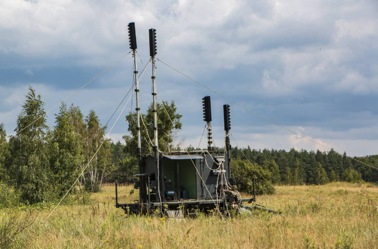 Image: The Russian army’s R-330ZH Zhitel electronic warfare system is considered one of the culprits behind the interference of GPS signals in Ukraine, specifically optimized to target GNSS signals. As shown, the system’s antenna is mounted on a trailer. Image source: Russian Ministry of DefenseHowever, every military advantage eventually produces a weakness, as countermeasures are developed to offset the tactical or operational advantages of innovations. In 2003, the US again led Operation Iraqi Freedom (OIF) in the Arabian desert. This time, the goal was not to liberate Kuwait but to oust Iraqi dictator Saddam Hussein. In the lead-up to the war, media reports indicated that the Iraqi military had purchased jammers capable of attacking GPS satellite signals. Clearly, the Saddam Hussein regime was determined to protect potential targets within Iraq from GPS-guided weapon attacks. The Iraqi rulers undoubtedly noted the revolution in precision-guided munitions (PGMs) that had occurred since “Desert Storm.” US government data shows that 9% of all weapons used in that campaign were precision-guided munitions. By 1999, during Operation Allied Force (OAF), the proportion of PGMs in all air-dropped munitions had increased to 35%, many of which were GPS-guided.NATO implemented Operation Allied Force over Kosovo and Serbia with the aim of preventing Serbia from committing ethnic cleansing against the Albanian population in Kosovo. OAF was the first to employ the revolutionary PGM, the Joint Direct Attack Munition (JDAM) guidance kit developed by Boeing. The JDAM kit consists of a nose and tail assembly equipped with a series of “dumb bombs.” The JDAM components combine GPS receivers with an Inertial Navigation System (INS) to receive GPS PNT signals. These signals enable the weapon to determine its position relative to the target. During flight, the tail assembly continuously adjusts the bomb’s flight path to ensure it stays as close to the target as possible. Publicly available information states that when GPS and INS are used simultaneously, the JDAM kit can provide a Circular Error Probable (CEP) accuracy of up to 5 meters. If GPS PNT signals are unavailable, enhanced JDAM bombs can still reach the target, but accuracy will diminish. If only INS is used, the bomb will land within 30 meters of the target.
GPS Codes
As mentioned, the GPS satellite constellation sends signals through two main links (primarily L1 and L2). Newly added satellites to the GPS constellation transmit PNT signals at a frequency of L5, which is 1.17645 GHz. All PNT signals from the GPS constellation belong to the L-band (1-2 GHz). The use of the L-band was a deliberate choice by the designers of the GPS system. At the time, the L-band had enough space to accommodate the relatively wide 20 MHz GPS signal. Additionally, L-band signals tend not to suffer excessive attenuation due to weather conditions. Omnidirectional antennas can also be used to receive L-band signals. This means that in practical use, GPS receiving antennas do not need to be pointed directly at the satellites to obtain signals.GPS signals must pass through the ionosphere on their way to Earth, which is the ionized part of the atmosphere between 48 kilometers and 965 kilometers above the Earth’s surface. The atoms in the ionosphere are excited by solar radiation, and this excitation can cause problems for some radio signals traveling from space to Earth. The ionosphere can also cause some signals to experience delays as they approach Earth, but these delays are often manageable for L-band signals. Ionospheric delay is the reason for using multiple link frequencies. By using GPS receivers that simultaneously acquire signals from both the L1 and L2 links, the receiver can compare each signal and account for ionospheric delays.Since navigation relies on precise timing, GPS satellites are equipped with atomic clocks that output a stable frequency of 10.23 MHz. This means that the atoms constituting the radioactive material of the satellite’s atomic clock resonate 1,023,000 times per second. The frequency used by the GPS constellation signals is a multiple of this 10.23 MHz frequency. For example, the L2 frequency is 120 times the 10.23 MHz signal. The L1 signal is 154 times the 10.23 MHz signal.GPS satellites transmit encoded signals. The civilian standard encoded signal is called C/A, which stands for Coarse Acquisition, transmitted via the L1 link and is unencrypted. L1 also carries the military encrypted Precise (P) code and will soon carry the military encrypted M code. Additionally, L1 also carries the new L1C civilian code. L1C is transmitted by the GPS Block III constellation, with its first spacecraft launched in December 2018. The frequency used for the new signal is 1.57542 GHz. Although there is not enough space here to fully explain the differences between the L1 and L1C signals, it is worth noting that L1C provides better interoperability between GPS receivers and the EU’s Galileo Global Navigation Satellite System constellation.All GPS satellites launched since 2005 have the L2C signal, which is a relatively new signal that allows civilian GPS users to correct for ionospheric delays, thus improving accuracy, although civilian GPS receivers using this signal are scarce. Starting in May 2010, an additional signal called L5 was introduced, with a transmission frequency of 1.17645 GHz. The L5 signal is primarily used for safety-of-life applications, such as emergency locator beacons and civil aviation.These signals transmit codes composed of multiple “bits,” essentially 1s and 0s, also known as “chips.” These bits are generated in a pseudorandom manner, meaning they are generated by a computer but are statistically considered random. Each bit sequence is transmitted at a set rate of bits per second and lasts for a specific duration. The GPS receiver generates a copy of the GPS code at a specific moment and records the time it takes to receive the incoming code from the satellite. The receiver calculates the time difference between each 0 and 1 in the received code and the time difference relative to each 0 and 1 in the copied code. Assuming this time difference is one second. Like all radio transmissions, PNT signals propagate at the speed of light (299,792 kilometers per second in a vacuum), so a one-second interval corresponds to approximately 299,792 kilometers. Therefore, the distance from the GPS receiver to a specific satellite is this distance. To determine its position, the receiver must obtain PNT signals from at least three other satellites. By repeating this process and triangulating from the three positions provided by each satellite, the receiver can determine its location. Image: In addition to the interference issues faced by the “Excalibur” shell, the JDAM guidance components provided to Ukraine have also encountered similar fates. For security reasons, the GPS-guided weapons supplied to Ukraine may not have been equipped to receive P(Y)-code signals. Image source: US Air ForceA general rule of thumb regarding GPS is that the faster the signal’s bit rate per second, the more accurate the GPS receiver will be in determining its position. The C/A code sequence transmits at a rate of 1,023 bits per second, meaning the C/A code sequence repeats every millisecond at a rate of 1,230,000 bits per second. The P code is transmitted via the L1 and L2 signals, but the main difference between the P code and the C/A code is that the former is transmitted at a rate of 12,300,000 bits per second, ten times faster than the latter. A higher bit rate per second provides more precise time delay measurements, which translates into more accurate distance measurements, and since the P code is transmitted simultaneously on both L1 and L2, it can eliminate ionospheric time delays. Douglas Loverro, president of Loverro Consulting and former Deputy Assistant Secretary of Defense for Space Policy at the US Department of Defense, stated that the C/A code can provide accuracy of about 4 meters. Loverro, one of the main designers of the Global Positioning System, stated: “The P-code can reduce accuracy to below 3 meters (10 feet).”The P code is protected by encryption technology to avoid being deceived or jammed by the encrypted P(Y)-code signal. “Loverro explained, “P(Y)-code was designed with encryption technology to prevent the signal from being deceived and to prevent others from using P signals that they should not be using. For a GPS receiver to use the P(Y)-code, two things must happen. First, when the receiver is powered on, it must first acquire the C/A code. Once the C/A code is obtained, the receiver can then begin receiving the P(Y)-code. Loverro pointed out that if the C/A code signal is locally jammed, this could be a potential disadvantage. Any GPS receiver within the jamming range cannot receive the C/A code, let alone the P(Y)-code. It is worth noting that some GPS receivers can currently receive the P(Y)-code without first acquiring the C/A code. Loverro added that to use the encrypted P(Y) code, users need a decryption key that can be loaded into the GPS receiver. The key can decrypt the received P(Y) code, allowing the receiver to utilize that signal.The US Department of Defense authorizes users to receive the P(Y) key and load it onto their devices. Given that the Ukrainian military has experienced interference while using GPS-guided weapons, it is currently unclear whether these weapons’ GPS receivers are equipped with P(Y) code capabilities. This may not be surprising. According to Loverro, the rights to use the P(Y)-code are reserved for NATO allies of the US on a case-by-case basis. The Department of Defense is understandably concerned that sharing the P(Y) code with Ukraine could result in the decryption key falling into Russian hands.
M Code
With the emergence of M-Code, the shortcomings of the P(Y) code are being addressed. Although M-Code has not yet been put into use, it may become a significant improvement. First, M-Code transmits via L1 and L2 signals. The power of the signal transmission is greater, and its resistance to interference is stronger. It does not need to connect with the C/A code before use. M-Code can also “work well” with existing C/A codes and P(Y)-codes, and like P(Y)-code, M-Code is also encrypted. The good news is that the US and allied forces are currently adopting M-Code. The bad news is that the Ukrainian military is unlikely to obtain M-Code for reasons similar to those surrounding the P(Y)-code dilemma. Image: The emergence of M-Code is expected to bring about a dramatic change in the resilience of Global Positioning System signals, although regular use of this code in the US and allied forces may still take some time. Until then, P(Y) code will continue to be used to provide secure GNSS PNT signals. Image source: BAE SystemsNevertheless, Russian electronic warfare personnel may soon discover that turning on GPS jammers equates to signing their own death warrant. According to a May report from Defense News, the Science Applications and Research Association (SARA) has obtained a $23.6 million contract to provide JDAM home-on-jam (HOJ) capability. Specifically, this will enhance the GPS receivers used in the GBU-62 JDAM-ER (Extended Range) variant guidance kit. Details on how the HOJ capability works remain unclear, but it may involve programming the GPS receivers to recognize anomalous GPS signals. As mentioned, GPS jamming typically relies on using much stronger false PNT signals to mask the relatively weaker true signals.
 Image: The GBU-62 JDAM-ER guidance kit is enhancing its “home-on-jam” capability, which helps guide munitions towards the GNSS jammers that are attacking them. This new capability will make life very unpleasant for Russian electronic warfare personnel implementing GPS jamming in Ukraine. Image source: BoeingIf the receiver detects a jamming signal, it will determine the direction of the signal. The munitions will self-guide along that direction until they reach the origin of the signal and make a “bang” to announce their arrival. This tactic is similar to that of anti-radiation missiles against enemy ground-based air reconnaissance and fire control/ground control radar. Although Kyiv is unlikely to obtain the P(Y) code key in the short term, or even be able to use M code, the Ukrainian military has already obtained JDAM-ER weapons. Reports regarding the HOJ capability indicate that Ukraine will gain this capability, with the work expected to be completed by October 2025. While this date may seem distant, the upgraded JDAM-ER could gradually be implemented as an integral weapon for the Ukrainian military. Looking ahead, perhaps future HIMARS and “Excalibur” will also see similar improvements. Regardless, these upgraded weapons will present Russian warning personnel with a Hobson’s choice: turn on the jammers to protect troops and assets from GPS-guided weapon attacks? Or turn off the jammers to save themselves, potentially leaving their comrades in dire straits? How the Russian military resolves this dilemma remains to be seen.Convenient Access to Specialized Knowledge
Convenient Download, please followSpecialized Intelligence Defense WeChat account (click above to follow)
WeChat account Reply “GPSW” to obtain the download link for “Electronic Warfare on the Battlefield: GPS Signal Interference in the Russia-Ukraine War” Specialized Knowledge
Welcome to scan the QR code to addSpecialized Assistant, for consulting services:Customized report materials, technology development

 Specialized Knowledge, a professional and reliable AI knowledge distribution platform, enabling cognitive collaboration faster and better! Welcome to register and log in to Specialized Knowledgewww.zhuanzhi.ai, to access100,000+ AI (AI and military, medicine, public security, etc.) thematic knowledge materials!
 Click “Read Original“, to learn how to useSpecialized Knowledge to view and obtain 100,000+ AI thematic knowledge materials