China News Service, Beijing, March 31 (Reporter Sun Zifa)The solar radiation on the Earth’s surface is the fundamental energy source for life activities on Earth and is also a key factor affecting climate change, agricultural production, and solar energy utilization. Efficient and high-precision monitoring of this radiation has garnered significant attention.
Installing a “Sunlight Scanner” on the Earth’s Surface
The Aerospace Information Research Institute of the Chinese Academy of Sciences (AIRCAS) announced on March 31 that an international collaborative team led by Chinese scientists has recently installed a “Sunlight Scanner” on the Earth’s surface, capable of accurately monitoring changes in solar radiation, providing precise data support for clean energy utilization, agricultural yield estimation, climate change response, and human health.
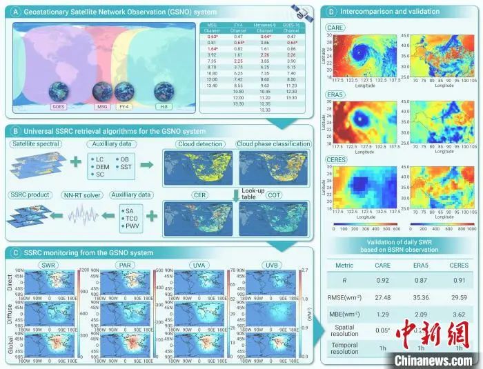
Depicted as the “Sunlight Scanner” on the Earth’s surface, the multi-satellite network Ground Solar Radiation Observation (GSNO) system and its results. Image provided by the Aerospace Information Research Institute of the Chinese Academy of Sciences.
The term “Sunlight Scanner” is a figurative expression; its professional name is the multi-satellite network Ground Solar Radiation Observation (GSNO) system based on the latest generation of geostationary satellites worldwide. It is led by Researcher Hu Silitu and Researcher Shi Chong from the Remote Sensing and Digital Earth National Key Laboratory of AIRCAS, in collaboration with the National Satellite Meteorological Center, the National Space Science Center of the Chinese Academy of Sciences, the Institute of Atmospheric Physics of the Chinese Academy of Sciences, and international partners including Tokai University, the University of Tokyo, Chiba University in Japan, Lille University in France, and the UK Met Office.
The research team established a multi-source heterogeneous satellite observation remote sensing model through the “Sunlight Scanner,” achieving the highest temporal and spatial resolution detection capability for solar radiation on a near-global scale while simultaneously improving detection accuracy. This groundbreaking achievement in the aerospace field has recently been published in the international academic journal “Innovation.”
Realizing Integrated Application of Chinese and Foreign Satellites
The research team introduced that based on the near-real-time remote sensing monitoring system for solar radiation developed in 2023, this breakthrough addresses remote sensing challenges arising from spectral differences and observational geometric differences during multi-satellite coordination, achieving integrated application of the latest generation of geostationary satellites, including China’s Fengyun-4 satellite, Japan’s Himawari-8 satellite, Europe’s second-generation meteorological satellites, and the US Geostationary Operational Environmental Satellite.
The integrated application of the “Sunlight Scanner” successfully enables continuous and seamless monitoring of solar radiation across Asia, Europe, North America, South America, Oceania, and Africa, filling the gaps left by low observation frequency of polar orbit satellites and limited observation areas of single geostationary satellites.
Researcher Hu Silitu pointed out that the “Sunlight Scanner” achieves a leap from regional to near-global observation through multi-satellite network observation, allowing for simultaneous analysis of near-global solar shortwave radiation (0.3 to 3 micrometers), photosynthetically active radiation (0.4 to 0.7 micrometers), ultraviolet A/B radiation, and their direct and scattered components.
Targeted Development of High-Precision Cloud Remote Sensing Algorithms
Ground solar radiation refers to the total solar radiation components (including ultraviolet, visible light, and infrared radiation of different wavelengths) received at the Earth’s surface, with clouds being the primary uncertain factor affecting solar radiation reaching the surface, posing one of the challenges in monitoring ground solar radiation.
Researcher Shi Chong stated that this research is based on the constructed intelligent cloud detection system and irregular ice cloud particle scattering model, combined with the spectral characteristics of different satellites, to specifically develop high-precision cloud remote sensing algorithms suitable for each satellite.
Additionally, considering the impacts of atmospheric aerosols, gases, and surface reflection, a rapid radiation transfer simulator combining artificial intelligence and radiation transfer models has been developed, achieving a 90,000-fold increase in radiation transfer calculation speed with an error of less than 0.3%.
“By integrating the above core technologies, we have constructed a remote sensing algorithm for ground solar radiation applicable to the GSNO system. Through algorithm innovation, we have solved the cloud interference and rapid radiation transfer calculation challenges for each satellite,” Shi Chong said.
Supporting Clean Energy Layout for the “Dual Carbon” Goals
Currently, the “Sunlight Scanner” can provide near-global ground solar radiation monitoring data with a spatial resolution of 5 kilometers and an observation frequency of once per hour, significantly outperforming similar international products, achieving an order of magnitude improvement in spatial resolution, and finely capturing local radiation changes such as typhoon paths and the Tibetan Plateau. By comparing with global ground-based measured data, the ground solar radiation data based on the “Sunlight Scanner” has a low daily average error and high accuracy, providing refined and high-precision support for local meteorological disaster monitoring and photovoltaic power station site selection, and offering data-driven insights for high temporal and spatial resolution Earth system models.
Hu Silitu believes that the “Sunlight Scanner” will assist in global solar energy resource assessment, supporting the clean energy layout under the “dual carbon” (carbon peak and carbon neutrality) goals. Its photosynthetically active radiation data can provide new bases for crop yield estimation and ecological carbon sink calculations, while the ultraviolet data module is expected to be applied in the public health field.
He revealed that the remote sensing data products for ground solar radiation based on the “Sunlight Scanner” have been published and shared on the “Cloud Remote Sensing, Atmospheric Radiation, and Renewable Energy” (CARE) website. The research team will continue to develop related radiation transfer models and satellite remote sensing data to better serve clean energy utilization and climate change research. (End)
Source: China News Service, copyright belongs to the original media/publishing website.


Some materials, resources, texts, images, etc., from this public account are sourced from the internet, and all reprints have been noted. If you find any infringement of your intellectual property rights or personal legal rights, please leave a message in the background, and we will promptly modify or delete it. Thank you for your attention and support!
GIS Circle Operation Team