In this issue, we focus on the satellite platforms and payloads for satellite internet.
Satellites are mainly divided into three categories based on their purposes or payloads: communication satellites, navigation satellites, and remote sensing satellites.

01 Overview of Satellites
(1) Navigation Satellites
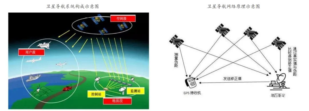
Satellite navigation is a space-based radio navigation system that uses navigation satellites as reference points. It is a technology that measures user positions using artificial Earth satellites, determining the position and motion state of a carrier through navigation signals sent by navigation satellites, guiding the moving carrier safely and effectively to its destination. Currently, satellite navigation employs the “four-star positioning” principle, using three satellites to ascertain the user’s geographic location, and then introducing a fourth satellite as a time reference to calculate time discrepancies, accurately resolving location information.
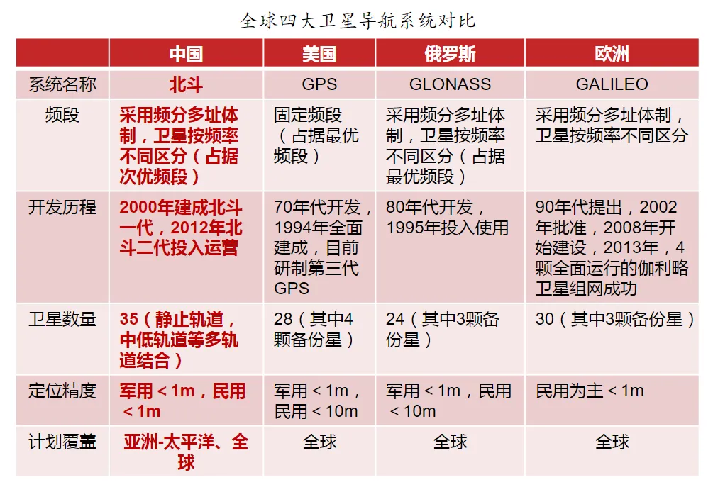
Currently, there are four major satellite navigation systems globally: the United States (GPS), China (BDS), Russia (GLONASS), and the European Union (GALILEO). Among them, the United States’ GPS is the only fully operational satellite navigation system, holding a 95% share of the global positioning market, leading the world in system maturity and service accuracy.
On June 23, 2020, China successfully launched the fifty-fifth navigation satellite of the BeiDou system, completing the deployment of the BeiDou-3 global satellite navigation system constellation.
(2) Remote Sensing Satellites
Remote sensing refers to the use of various devices for long-distance detection; the detected data can be images, signals, or various related data that can be analyzed and utilized. Remote sensing, which “sees far and high”, is of great utility and is highly valued by countries. Currently, many remote sensing monitoring satellites exist in the sky, which adopt different orbits, carry different monitoring instruments, and use various communication methods based on different objectives. Remote sensing satellite data has been widely used in surveying, land use, planning, environment, water conservancy, transportation, oceanography, forestry, agriculture, geology, electricity, public safety, and more. The application of remote sensing satellites allows humans to obtain valuable information in hard-to-reach areas such as deserts, swamps, mountains, and under ice layers, solving technical challenges in exploring uninhabited areas or deep oceans.
Based on the fields of Earth observation, remote sensing satellites are mainly divided into three types: land satellites, meteorological satellites, and ocean satellites.
Land satellites: Artificial Earth satellites that detect Earth’s resources and environment. They are mainly used for terrestrial resource surveys, monitoring, and evaluation. They are widely applied and are the main type of Earth remote sensing satellites, characterized by a wide range of information acquisition, diverse observation targets, and high demands for spatial and spectral resolution. Due to their broad applications, land satellites have a variety of payloads, such as instruments for transmitting/receiving electromagnetic waves across various bands, radar, and high-definition cameras.
Meteorological satellites: Artificial Earth satellites that conduct meteorological observations of the Earth and the atmosphere from space. They are mainly used for weather forecasting, climate prediction, typhoon monitoring, and flood disaster monitoring. Meteorological satellites have a wide observation range, frequent observation times, rapid timeliness, and high data quality, unaffected by natural or regional conditions. The main payloads carried by meteorological remote sensing satellites include visible light scanners and infrared scanners.
Ocean satellites: Artificial Earth satellites that observe the Earth’s ocean surface. They are mainly used for dynamic monitoring of ocean temperature fields, currents, waves, and salinity. They require high spectral resolution for remote sensing. The payloads of ocean remote sensing satellites generally include synthetic aperture radar, radar altimeters, microwave radiometers, and infrared radiometers.
Military reconnaissance satellites: Military reconnaissance satellites are also a type of remote sensing satellite, primarily used for military purposes, with multifunctional and multi-scenario applications, including electronic reconnaissance, missile warning, and ocean monitoring. During the Russia-Ukraine war, military reconnaissance satellites played a significant role on the battlefield. Due to their complex and diverse functions, military reconnaissance satellites often carry complex payloads, commonly used military reconnaissance satellite payloads include visible light cameras, infrared cameras, multispectral cameras, microwave cameras, laser radar cameras, and various electronic reconnaissance equipment. Typically, they carry high-resolution optical imaging systems, infrared imaging systems, low-light night vision systems, synthetic aperture radar systems, etc.
(3) Communication Satellites
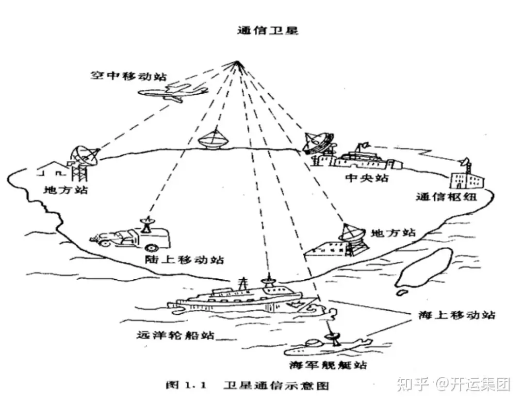
Communication satellites are satellites that provide relay forwarding or transmission of radio waves for wireless communication.
In simple terms, satellite communication is a method of communication between radio stations on Earth (including ground, water surface, and low atmosphere) using artificial satellites as relay stations to forward or reflect radio waves, thereby achieving communication between two or more Earth stations. It is a wireless communication method that can carry various communication services and is one of the important means of communication in today’s society.

02 Composition of Communication Satellite Platforms
Navigation satellites, remote sensing satellites, and communication satellites are all composed of satellite platforms and payload platforms, with significant differences in satellite platforms due to payload functions, weights, orbital altitudes, etc. This article mainly studies the industrial chain of communication satellites, describing from the perspectives of satellite manufacturing and communication payloads.
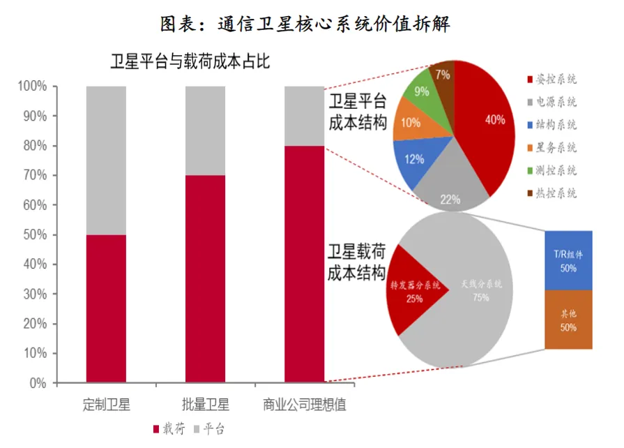
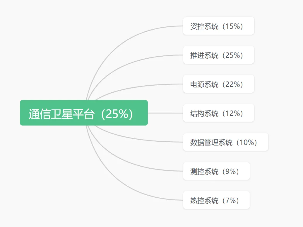
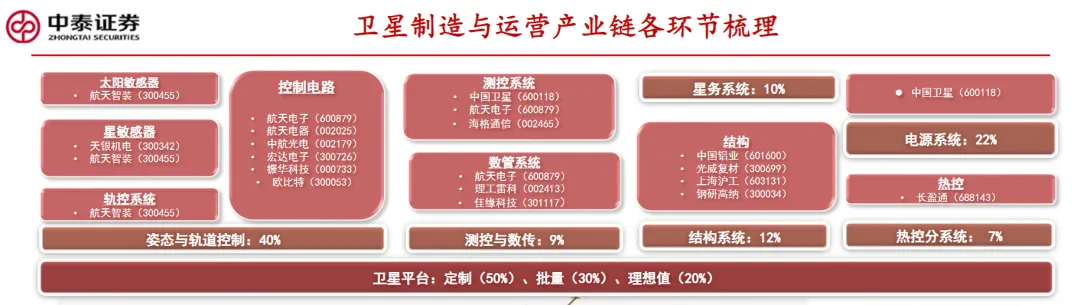
The communication satellite platform includes remote sensing measurement and control systems, power supply systems, structural systems, propulsion systems, data management systems, thermal control systems, and attitude and orbit control systems. Normally, the customized communication satellite platform and payload platform have a value ratio of about 1:1. With the implementation of satellite network plans, satellite platforms are gradually becoming standardized and modularized, leading to a gradual decrease in the cost of satellite platforms in satellites. It is estimated that in the future, the value ratio of satellite platforms in satellites will be around 25%-30%. The cost ratios of various subsystems are approximately as follows:
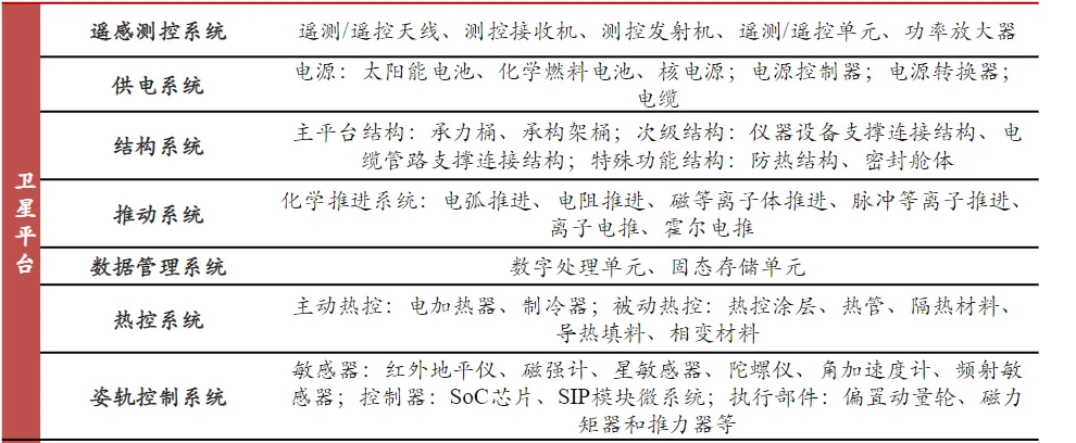
Remote Sensing Measurement and Control System: The measurement and control of satellites in orbit need to complete three main tasks: early testing, daily management, and end-of-life management. Early testing is to verify the performance indicators and overall design compliance of the satellite after it enters orbit; the test results are the basis for satellite delivery to users and business operations. Daily management involves remote sensing monitoring of the satellite’s operational status, clock correction, orbit injection, command transmission and reception, orbit measurement and external data processing, orbit maintenance control, attitude control, solar panel angle control, and managing the satellite’s orbital position drift to ensure normal operation of the satellite platform. End-of-life management requires that abandoned geostationary satellites be moved to a “satellite graveyard” approximately 300 km above geostationary orbit. Therefore, the last task for geostationary satellites in orbit measurement and control is to raise the satellite’s orbit, control it away from its fixed position to the “satellite graveyard”, and perform passivation treatments such as shutting down rotating components and discharging batteries. When low Earth orbit satellites descend sufficiently, they complete dense orbital measurements and accurately forecast their re-entry locations.
Power Supply System: After entering orbit, communication satellites need to interact with ground terminals for information exchange, attitude control, orbit changes, command sending and receiving, and other complex tasks, all of which require energy support. Thus, modern communication satellites use both solar panels and chemical batteries for power supply, requiring the power supply system to be compact, lightweight, efficient, and long-lasting. The power supply system plays a crucial role throughout the satellite’s life cycle, providing stable energy which directly affects the satellite’s power capability and lifespan. It is an indispensable part of the satellite system. The power supply system typically consists of three main components: the power controller, known as the “power manager”, which manages and controls the entire power system’s operation; the solar panel array, known as the “generator”, which captures solar energy and converts it into electrical energy; and the battery pack, known as the “storage tank”, which stores electrical energy to provide support when the satellite enters Earth’s shadow or requires additional power. The power supply system is responsible for energy conversion, transmission, and control throughout the satellite’s various phases, including ground testing, pre-launch testing, active flight, transfer orbit, and geostationary orbit life. It must dynamically adjust the power balance between the solar panel array, battery pack, and load, providing a fully adjustable power bus to ensure that the satellite platform meets the payload’s energy needs throughout its life cycle. Currently, China’s mainstream GEO satellite power supply systems use a 100V fully adjustable bus, with configurations including 6KW, 9KW, and enhanced 12KW in the Dongfanghong-4 platform, representing the latest development in high-power power supply systems for GEO satellites in orbit.
Structural System: The structural system is designed to support the functions of the satellite platform and payload platform, ensuring load-bearing, support, connection, heat dissipation, insulation, and sealing for various structures and components.
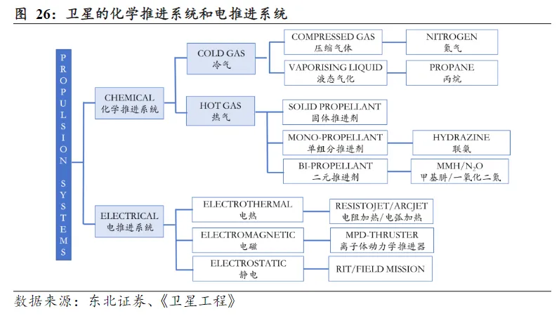
Orbit Propulsion System: The number of celestial bodies in the solar system is vast. According to the law of universal gravitation and the interactions among celestial bodies, various factors such as atmospheric effects during low orbit operations, solar radiation pressure, micro-meteorite impacts, and mechanical component influences can cause satellites to deviate from their orbits, leading to operational failures. Additionally, orbit control corrections must be made before satellite separation. For these reasons, an orbit propulsion system is required to provide power for the satellite’s operations in orbit. Therefore, for almost any satellite, the propulsion system is a critical component. The engine functions like a human heart, maintaining all vital activities.
The orbit control system for geostationary satellites mainly includes axial and lateral propulsion systems. The axial propulsion system controls the satellite’s drift in the latitude direction, while the lateral propulsion system controls the drift in the longitude direction caused by changes in orbital speed. These propulsion systems consist of small gas rockets that use a specific gas fuel, with ignition timing and burn duration precisely controlled by signals from ground measurement and control stations. Additionally, the propulsion system has attitude control capabilities, which can stabilize the satellite’s attitude through methods such as spin stabilization, gravity gradient stabilization, and magnetic stabilization. The basic principle of satellite propulsion is to generate thrust by expelling certain materials, thereby changing the satellite’s motion state. Currently, propulsion technologies are mainly categorized based on the propellant used.
Thermal Control System: A thermal control system is used to manage the internal and external temperatures of satellites in orbit to ensure that the satellite’s temperature remains within the required range. During orbital flight, satellites face extreme temperatures, both high and low. The sun is a massive heat source, and at altitudes from hundreds to thousands of kilometers, there is no air for conduction and convection heat dissipation, and the thin atmosphere cannot effectively block solar radiation, causing direct sunlight to hit the satellite’s surface. In this case, without measures, the satellite’s temperature would rise rapidly. However, when the satellite enters Earth’s shadow, it loses solar heat, leading to a sharp temperature drop. The satellite must operate between these high and low temperatures, typically fluctuating between 100 degrees Celsius and minus 100 degrees Celsius. Additionally, the Earth’s sunlight reflection and infrared low-temperature radiation can also affect the satellite’s surface temperature. Furthermore, the instruments inside the satellite generate heat during operation and need to dissipate it. Generally, electronic instruments can malfunction when operating in environments exceeding 50 degrees Celsius, while some devices, like chemical batteries, significantly lose efficiency in sub-zero environments. Therefore, despite the significant external temperature fluctuations, satellites must maintain a specific internal temperature range to ensure the normal operation of internal instruments. The thermal control system’s task is to ensure that the internal temperature of the satellite remains within a specified range. Typically, the internal temperature of the satellite is maintained between 5 and 45 degrees Celsius, with some parts allowing only 1-2 degrees of temperature variation.
Attitude and Orbit Control System: In theory, geostationary satellites have relatively stable positions in geosynchronous orbit, but in reality, satellites require constant orbit control to maintain their relative stationary state. This is because the Earth is not a perfect sphere but has some curvature, causing slight disturbances due to Earth’s gravitational effects, leading to orbital drift. Additionally, the gravitational pull from the sun and moon also affects the satellite, causing orbital disturbances that interfere with communication between the satellite and ground stations, even leading to signal interruptions. One of the tasks of the satellite’s orbit control system is to maintain and control the satellite’s position in orbit. It must ensure that the satellite stays at the designated position and maintains the correct attitude. This is crucial because directional antennas on satellites need to constantly point toward the Earth’s center or the communication area center, and the narrow directional beam is significantly affected by changes in satellite attitude. Additionally, solar panels must face the sun, making attitude control extremely important. Every tiny angle in the satellite’s flight attitude can affect the orientation of solar panels, signal reception, and the camera angles carried by the satellite. Therefore, satellites usually need to be equipped with sensors to determine their state and spatial orientation in real-time and make timely adjustments and corrections. These sensors include: solar sensors, star sensors, magnetometers, gyroscopes, etc.
Data Management System: The evolution of onboard storage systems is closely related to the development of storage media used in satellites, which have transitioned from tape drives, SRAM, SDRAM to NAND Flash. Currently, NAND Flash is the preferred medium for onboard data storage due to its non-volatility and excellent performance per unit area. In the field of onboard storage, SLC NAND Flash once dominated, but due to its high cost and low performance per unit area, it cannot meet the demand for high-speed and large-capacity satellite payload data storage. Therefore, the direction of development for onboard storage systems has shifted towards using high-capacity 2D MLC and 3D TLC NAND Flash with higher integration density per unit area.
The status of companies listed in satellite subsystems is shown in the following figure:
[Risk Warning] This series of research notes is a personal study summary and does not constitute investment advice. Investors should be cautious and make independent decisions.
(Source: Jinhui Capital)

Disclaimer
The content published by the WeChat public platform “Shaanxi Venture Capital Association” with marked sources is owned by the original source (those whose copyrights cannot be verified or are not marked are collected from the internet). The reproduced content (videos, articles, etc.) is for information dissemination purposes only, for reference only, and does not represent the platform’s endorsement of its views and positions. The authenticity, accuracy, and legality of the content are the responsibility of the original author.