Author: Song Jun (Huawei Technologies Co., Ltd. Nanjing Research Institute)
Abstract: Intelligent transportation is the development direction for China to become a transportation powerhouse. This article introduces the application of edge computing in intelligent highways, as well as the three-level computing platform architecture of intelligent highways. It proposes a network architecture for intelligent highways and analyzes case studies of edge computing network solutions for two core scenarios of intelligent highways.
Intelligent highways should meet the needs of three parties: (1) For travelers, provide safe, smooth, economical, and all-weather passage conditions, timely and accurate traffic information services, and comfortable travel services such as entertainment, dining, and tourism; (2) For traffic managers, provide real-time and periodic traffic data and other information for road traffic control and optimization decision-making, reduce safety risks, and improve road operation efficiency; (3) For road operators, provide intelligent perception of vehicles, roads, and the environment, automatically discover anomalies and risks, provide scientific data support for managers to conduct analysis and predictions, and offer integrated and intelligent control means to promptly eliminate abnormal situations, ensuring road network safety and smoothness, while providing quantitative indicators for long-term operational decision-making. Currently, there is still a significant gap between existing highways and intelligent highways, reflected in the lack of effective accident prevention capabilities and efficient accident handling efficiency, the inability to achieve holographic perception of road operation status and effective traffic diversion, incomplete road service information, and inefficient vehicle-road collaboration. 1. Application and System Architecture of Edge Computing in Intelligent Highways(1) Information Characteristics of Intelligent Highways Intelligent highways fully utilize new generation information technologies such as the Internet of Things, spatial perception, cloud computing, and mobile internet in the field of transportation, comprehensively applying theories and tools from traffic science, systems methodology, artificial intelligence, and knowledge mining, aiming for comprehensive perception, deep integration, proactive service, and scientific decision-making. By building a real-time dynamic information service system and deeply mining transportation-related data, it forms problem analysis models, enhances the ability to optimize industry resource allocation, public decision-making, industry management, and public service capabilities, promoting safer, more efficient, more convenient, more economical, more environmentally friendly, and more comfortable operation and development of transportation, driving the transformation and upgrading of transportation-related industries. Advanced intelligent highways can achieve a networked and collaborative intelligent management environment, capable of fully automatic and comprehensive service and supervision of the road network; they can achieve high-precision perception across all time and space, digital processing of trajectories of all road participants, accurate calculation of traffic operation status on the road network, and precise decision-making and management of traffic operation systems at different road sections and levels; they can achieve collaborative management of mixed traffic flows of manually driven and autonomous vehicles, meeting the needs for autonomous vehicle fleet formation and online scheduling. The information construction of intelligent highways should have the following four characteristics: (1) Digitalization of infrastructure, where all classifications and attributes related to roads have complete digital representation across all airspace and time, allowing effective organization and use through computer systems, ensuring the completeness of road asset attributes and clarity of management processes. (2) Intelligent perception, including the ability to perceive the operational status of infrastructure equipment, environmental conditions, and traffic participant capabilities. (3) Efficient and low-latency communication capabilities, integrating infrastructure, various assets, managers, and users efficiently through communication systems to ensure rapid integration and real-time exchange of information among all parties. (4) Massive data processing and analysis capabilities, capable of storing and retrieving massive amounts of data, supporting multi-source data fusion across business platforms, and possessing big data analysis and artificial intelligence data feature extraction capabilities. (2) Digital Business Processes of Intelligent Highways The business process of the digital information flow of intelligent highways is divided into three parts: collection of real-time comprehensive perception and related information of roads; AI analysis and processing of the digital information flow of roads by the computing platform; and publication of processed information and sharing of digital information of roads. 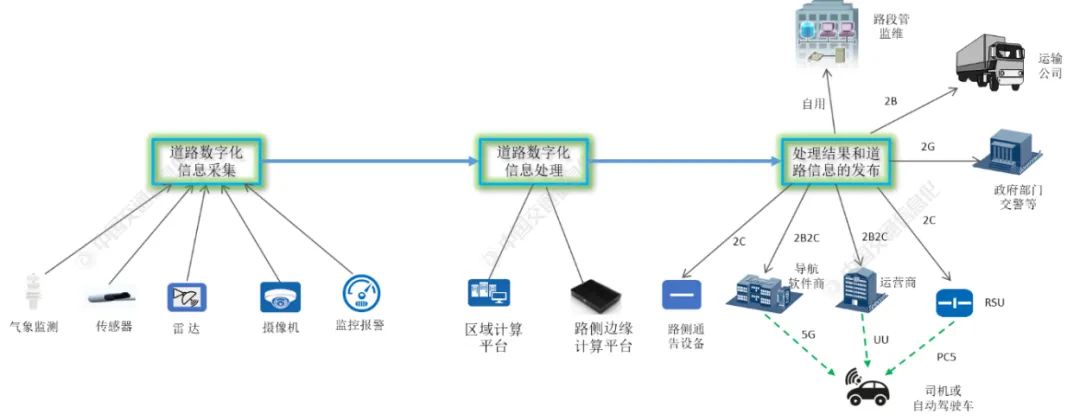 Figure 1: Business Process of Digital Information Flow in Intelligent Highways The information system of intelligent highways completes the digitization of vehicles, various facilities, and traffic events on the road through various roadside sensing and monitoring devices, such as cameras, radar, meteorological monitoring systems, pavement sensors, and road electromechanical monitoring and alarm systems, forming an information flow that can be processed by computers, and summarizing it to the intelligent highway information system through the roadside network system. The intelligent highway information system computing platform mainly refers to the roadside edge computing platform, which performs AI analysis and processing on the collected digital information of roads, producing real-time dynamic digital holograms of roads and real-time analysis and prediction results of various road events. This result information holds significant value for all road stakeholders, with some needing to be published promptly. The digital information and analysis results from the computing platform of intelligent highways should be sent to all stakeholders through multiple channels. They are sent to the segment management center for management, monitoring, and operation and maintenance, and can also provide a basis for subsequent big data analysis; sent to transportation companies to provide information services for vehicles in transit; sent to traffic management departments, traffic police, and relevant government departments to support real-time control of highways; sent to vehicles and traffic participants on the road to provide real-time information services for vehicle-road collaboration. Currently, there are four main ways to publish vehicle-road collaboration information: (1) Directly sent from roadside RSUs to vehicles and traffic participants on the road, i.e., the standard-defined PC5 interface. This transmission method has a delay of within tens of milliseconds, meeting the high real-time publishing needs of safety-related vehicle-road collaboration information on highways, preventing secondary accidents and other traffic incidents. (2) Sending result information to vehicles via the operator’s 5G mobile network dedicated channel, i.e., the standard-defined UU interface. The transmission delay is greater than method (1), but if the network transmission is well-planned, the delay can be guaranteed to be between hundreds of milliseconds to seconds. (3) Sending to vehicles via navigation software on the 5G mobile network, where the transmission delay cannot be guaranteed. (4) Providing roadside announcement devices, such as electronic information boards, to display result information to vehicle drivers. Autonomous driving requires intelligent highways to provide a “God’s eye view” vehicle-road collaboration service to compensate for the shortcomings of single-vehicle perception, effectively improving the safety of autonomous driving. For instance, autonomous vehicles cannot perceive whether the road surface ahead is icy or see blocked traffic accidents and traffic signal information. Intelligent highways are not limited to vehicle-road collaboration services; they serve all stakeholders related to the road. Vehicle-road collaboration services are also not limited to serving autonomous driving; they are expected to serve mainly drivers of manually driven vehicles and other traffic participants for a considerable time. The real-time requirements for vehicle-road collaboration services provided by autonomous driving are the highest. Considering the high speed on highways, many services require real-time performance within 100ms, and only information publishing method (1) can meet this requirement. (3) Application of Edge Computing and Computing Platform Architecture in Intelligent Highways The computing platform is the core of the intelligent highway system. Unlike traditional video surveillance systems, the newly added edge computing platform is a core subsystem of intelligent highways. The roadside edge computing platform obtains data from roadside sensing devices in real-time for fusion computation, providing higher precision and more reliable fusion perception results and traffic events with high-performance computing capabilities. It performs functions such as target recognition, classification, tracking, and trajectory stitching, and can also provide accurate data services for road traffic participants through vehicle license plate recognition and motion attribute prediction. The computing platform’s distributed deployment to the roadside edge allows most intelligent traffic operations to complete local business loops at the roadside, simplifying business processing, improving real-time performance and efficiency, and enhancing the robustness of intelligent highway operations. The output of AI algorithm analysis results from the roadside edge computing platform can be sent directly to vehicles and relevant traffic participants on the road via RSUs, with a delay in the millisecond range, meeting the vehicle-road collaboration information needs of autonomous vehicles on highways; it can also be sent to vehicles and relevant traffic participants via the operator’s 5G network; or sent to drivers via navigation software apps. At the same time, the data collected by the roadside and the analysis results from the edge computing platform are all summarized and sent to the regional computing platform. Intelligent highways adopt a three-level computing platform system, as shown in Figure 2. The roadside edge computing platform obtains data from roadside sensors in real-time for fusion computation, outputs fusion perception analysis results and traffic events, quickly responding to application needs and message publishing at the edge of the highway. The regional computing platform is generally deployed in the machine room of the segment center or segment sub-center, processing information aggregated from various edge computing platforms, completing remote sending of traffic events, such as broadcasting sudden accident events; managing devices, models, algorithms, and applications related to edge computing platform node management; and requiring real-time information processing and real-time communication. The provincial computing platform implements comprehensive traffic management and scheduling command at the provincial level and provides service rules for regional services. The provincial computing platform and regional computing platform provide information services to external commercial users, individual users, and government departments, such as providing real-time road information to traffic participants through operators (UU mode).
 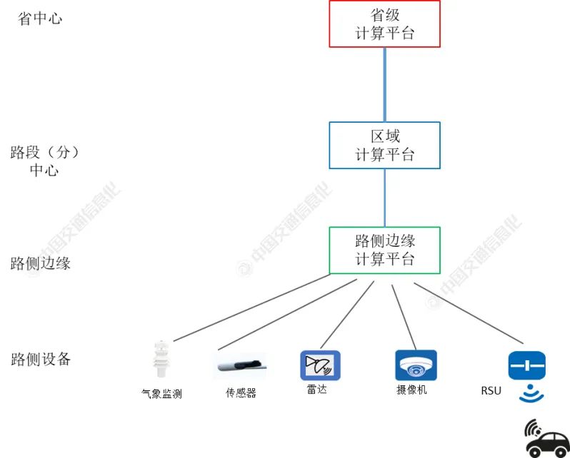 Figure 2: Three-Level Computing Platform System of Intelligent Highways To improve the real-time performance of intelligent highway operations, AI analysis processing efficiency, high real-time efficiency of message publishing, and robustness of operations, the intelligent highway business system has added a roadside edge computing platform to complete local business loops. 2. Network Architecture and Edge Computing Network Solutions for Intelligent Highways(1) Network Architecture of Intelligent Highways The network of highway systems is generally planned and constructed on a provincial basis, which can be divided into two parts: segment access network and provincial trunk network, as shown in Figure 3.
 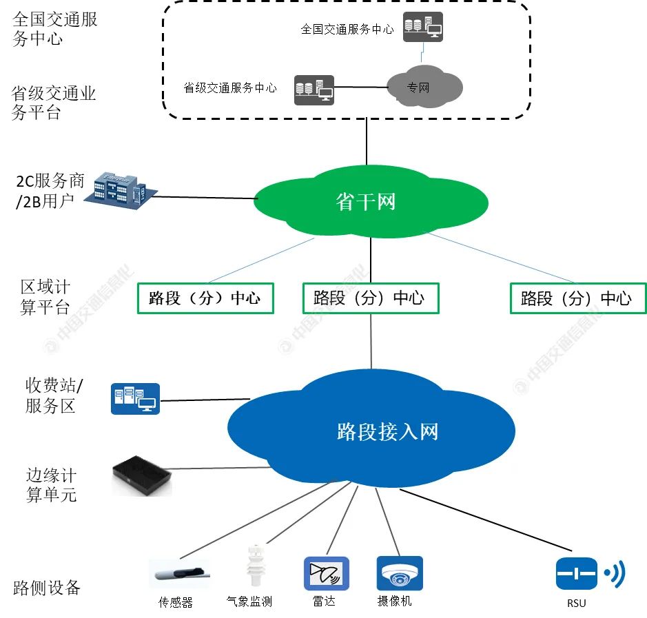 Figure 3: Network Architecture of Intelligent Highway Systems The segment access network is responsible for interconnecting roadside devices, edge computing units, and segment sub-centers; if there is no segment sub-center, it connects directly to the segment center. Among them, roadside devices include RSUs, intelligent roadside sensing devices (various cameras, laser radars, millimeter-wave radars, etc.), dynamic traffic information boards, roadside meteorological sensing stations, etc. The edge computing units can perform fusion judgment on the raw data information output from roadside devices, extract structured road and target state information, and perform data analysis and processing to support various applications of intelligent highways; many vehicle-road collaboration operations complete business processes in the roadside network, which has high real-time and bandwidth requirements. The segment access network may have various networking modes to support fully distributed or relatively centralized deployment of edge computing units. The provincial trunk network is responsible for communication interconnection between segment sub-centers, communication interconnection between segment sub-centers and segment centers, communication interconnection between segment centers, communication interconnection from segment centers to provincial centers, and business communication between provincial centers and 2C service providers/2B users. Vehicle-road collaboration business communication between segment sub-centers and segment centers has real-time requirements. UU mode vehicle-road collaboration information is transmitted through dedicated external lines connected to 2B users (including operators). (2) Edge Computing Network Solutions for Intelligent Highways The intelligent highway scenario is divided into five major scenarios according to the components of the highway: general segments, mainline tunnels, toll station interchanges, hub interchanges, and service areas. General segments are the main scenarios of highways, while mainline tunnels are the most complex scenarios of highways. This section focuses on the edge computing network solutions for these two scenarios. The edge computing network solution for general segments is illustrated in Figure 4. Every 200 meters along the highway, a pole station is set up, deploying sensing devices (cameras, radar, etc.) and RSUs according to the needs of intelligent highway operations, with all pole-mounted devices connected to a pole-mounted switch; all pole-mounted switches and aggregation routers form a ring-type roadside access network, with aggregation routers also connected to the roadside edge computing platform, transmitting the information data collected by sensing devices in real-time to the edge computing platform for fusion perception AI analysis, and sending the output results from edge computing in real-time via RSUs to vehicles and traffic participants on the highway. If the pole-mounted switch is replaced with an access router, pushing L3VPN to the pole station can greatly improve the flexibility of networking, simplify the configuration of device access and communication security for various services, and expand the number of nodes that can be connected to the access ring network.
 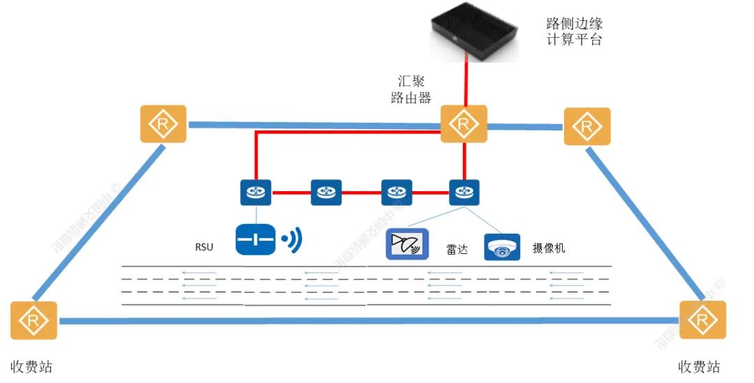 Figure 4: Edge Computing Network Solution Case for General Segments The roadside access network adopts a ring structure, firstly to save fiber resources, as only two sets of fibers are needed to build a ring network, and secondly to prevent single-fiber breakage faults to ensure network reliability. The access roadside network generally adopts a GE ring network, configured with a ring network protection mechanism, which can complete protection switching within 50ms in the event of a fiber breakage fault or a fault in a pole-mounted switch, ensuring that vehicle-road collaboration operations are not affected. Aggregation routers are connected in series, interconnecting with aggregation routers in the communication room of nearby toll stations to form an aggregation ring network. The aggregation ring network generally has a bandwidth of 10GE, and all aggregation routers share the ring network bandwidth, thus, considering bandwidth and reliability, the number of aggregation routers on the aggregation ring network needs to be controlled, generally not exceeding 10 nodes. Between two toll stations, multiple aggregation ring networks can be built as needed, all centered around the aggregation router of the toll station. The pole stations for general segments have two deployment modes: roadside deployment and central median deployment. In the roadside deployment mode, access ring networks and aggregation ring networks are built on both sides of the road. In the central median deployment mode, access ring networks and aggregation ring networks are deployed in the central median. Due to the strong correlation between mainline tunnels and the preceding and following segments, it is usually designated that the road segments within a 500m range outside the tunnel are included in the tunnel management area for centralized control and message publishing. Bidirectional tunnels and the 500m segments outside the tunnel constitute an independent “tunnel logical unit” and require the deployment of a tunnel-level edge computing platform to support collaborative computation and analysis of business data across the entire tunnel area. As shown in Figure 5, edge computing access ring networks and aggregation ring networks are deployed in each of the two one-way tunnels, with routers in the tunnel electromechanical room serving as the core aggregation of the aggregation ring network. Inside the tunnel, network stations are installed approximately every 150 meters, connecting sensing devices (cameras, radar, etc.), RSUs, tunnel detection systems, detection alarm systems, and IP alarm phones, and other electromechanical devices in the tunnel. The tunnel-level edge computing platform conducts AI analysis and decision-making based on all tunnel-related information received, especially providing rescue instructions in abnormal situations, including unified rescue scheduling across two tunnel holes and guidance for vehicles on the highway outside the tunnel.
 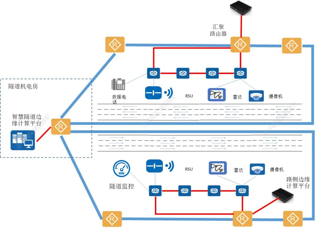 Figure 5: Edge Computing Network Solution Case for Mainline Tunnels Generally, a tunnel-level edge computing platform can be concentrated in shorter tunnels, while in longer tunnels, two levels of edge computing platforms (tunnel-level edge computing platform and roadside edge computing platform) are deployed. 3. Conclusion The computing system of intelligent highways generally consists of a roadside edge computing platform, a regional computing platform, and a provincial computing platform. The roadside subsystem composed of the roadside edge computing platform, roadside sensing devices (cameras, millimeter-wave radar, laser radar, various sensors), and RSUs (roadside communication units) is the core subsystem for completing intelligent highway operations. The roadside edge computing platform obtains data from roadside sensing devices in real-time for fusion computation, providing higher precision and more reliable fusion perception results and traffic events with high-performance computing capabilities. To improve the real-time performance of intelligent highway operations, AI analysis processing efficiency, high real-time efficiency of message publishing, and robustness of operations, the intelligent highway business system has added a roadside edge computing platform to complete local business loops. References[1] Edge Computing Industry Consortium (ECC)/Edge Computing Network Infrastructure Working Group (ECNI), www.ecconsortium.net.[2] IMT-2020(5G) Promotion Group/Cellular Vehicle-to-Everything (C-V2X) Working Group, www.v2x.caict.ac.cn.(Originally published in the 2022 6th issue of China Transportation Informatization)Editor: Cui Xuewei