
1. Research and Development Background
In recent years, in the military field, the application of virtual interaction technology between humans and combat environments, along with integrated systems, has greatly helped to address many practical issues in real combat training, such as high costs and environmental constraints. This has attracted the attention of military forces worldwide, with the use and popularization of digital electronic sand tables being particularly widespread.
康硕展 has developed the LEDEST (LED Electronic Sand Table) smart sand table whiteboard specifically for the unique application scenarios of military electronic sand tables. This device can seamlessly integrate with various systems and interact with multiple smart hardware, providing users with an intelligent, efficient, and simple new management experience for combat rooms. LEDEST also features integrated meeting management capabilities such as search queries, appointment notifications, status displays, approval repairs, and personnel services, establishing a full lifecycle meeting service system.
2. Introduction to LEDEST Electronic Sand Table
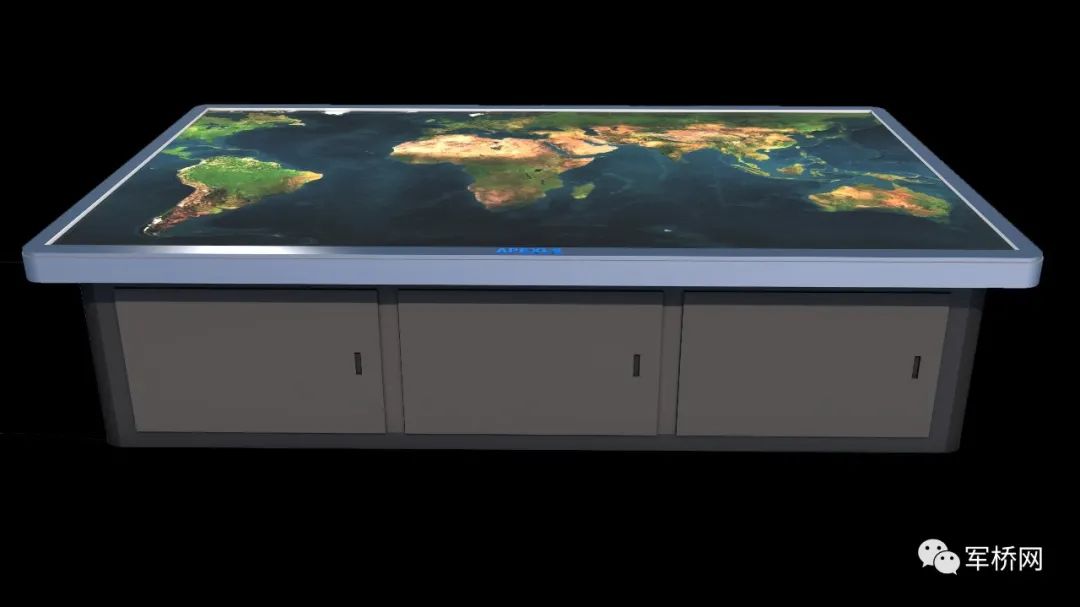
The LEDEST smart sand table from 雷曼·康硕展 adopts an All-In-One design
The military digital electronic sand table is a modern information display tool that meets the current needs for highly automated command, rapid response, and three-dimensional war situation display. Its core design is based on virtual interaction technology between humans and combat environments, primarily utilizing computing devices, such as computers, to generate simulated combat environments. Through multi-channel input, it allows humans to enter virtual combat environments, significantly enhancing decision-making capabilities and response speed in command support. Currently, replacing traditional paper work and sand table models with digital electronic sand table systems composed of COB large screens, multi-touch, and high-performance computers is a highly effective approach.
In addition to the above applications, it can also assist military personnel in training overall combat capabilities and individual skills during regular times. It can serve as a tool for reporting combat situations, allowing leaders to intuitively and efficiently understand the situation. It can also be used as a tool for military teaching and research.

3. Eight Core Functions of the LEDEST Electronic Sand Table
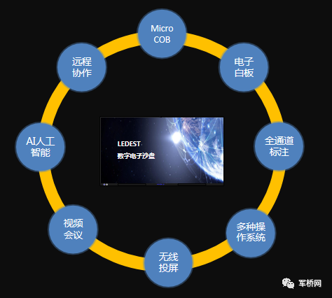
Core Functions of the LEDEST Electronic Sand Table
① Micro LED: High protection, high reliability, high definition, and excellent picture quality;
② Smart Writing: Single-finger writing, dual-finger zoom, multi-finger roaming, and backhand erasing;
③ Wireless Screen Sharing: Supports PC and other hardware screen sharing, 9-split screen display;
④ Video Conferencing: Cross-platform video cloud, meeting support for hardware conference terminal access;
⑤ Remote Collaboration: Remote screen sharing, screen sharing, remote assistance, and multi-party whiteboard;
⑥ Smart Dual System: Built-in powerful operating system, optional high-performance OPS computer;
⑦ Integrated Design: Highly integrated, seamless connection, aesthetically pleasing and user-friendly;
⑧ Strong Alliance: Huawei HiSilicon chip, Huawei cloud meeting system.
4. Advantages of the Electronic Sand Table Product
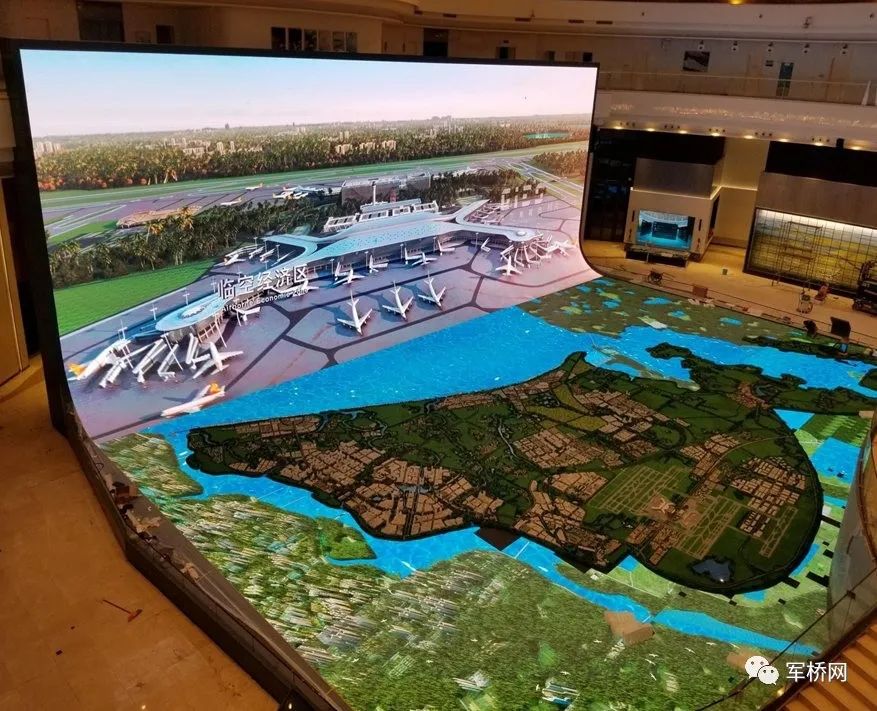
康硕展 immersive electronic sand table
1.Military Standard Symbol Library
2.2D and 3D Situation Mapping
Equipped with integrated 2D and 3D mapping editing capabilities, allowing for interactive editing of military standard numbers and basic graphic element numbers on 2D maps and 3D globes, providing creation, movement, control point editing, deletion, cutting, copying, pasting, and locking functions, and supports multi-level undo and redo of editing operations.
3.Supports Offline Mode
In offline mode, the comprehensive application software directly accesses local geographic data files. Local data files are sourced from geographic data processing tools.
4.Technical Indicators
The system supports CGS2000 and WGS84 geodetic references; supports multiple graphic system APIs (supports DirectX 9 / 10 / 11 / OpenGL) rendering; fully supports 64-bit operating systems; can display a maximum of ≥6000 labels simultaneously on 2D maps and 3D digital earth; the output of a single bitmap is no less than 10000*10000 pixels; the maximum precision for 3D image is supported at 0.1 meters or more, and vector data supports 1:2000 or more; provides terrain generation tools that create 3D terrain using raw elevation and satellite data in GeoTiff format.
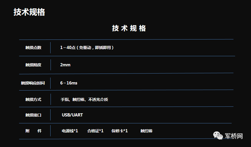
5. Technical Specifications
6. Main Applications
1. Combat Command
Using the intelligent interactive digital electronic sand table system for battlefield command scheme planning, it can intuitively layout the system based on task requirements, while simultaneously calculating specified parameters in the plan, providing auxiliary evaluation of planning effects, and offering real-time intelligent support for scheme planning. After the planning is completed, it can simulate the planning task, displaying various parameters during the simulation process, supporting constraint verification and parameter optimization of the planned scheme.
2. Training Simulation
Simulation training, also known as simulation modeling, involves modeling in the military field and then using simulation techniques to simulate battle situations, strategies, and tactics. This method applies systems theory and utilizes various modeling methods such as mathematical modeling. In practice, simulation training plays a significant guiding role in military command.
3. Virtual Confrontation
The 雷曼·康硕展 military smart electronic sand table can dynamically display three-dimensional information of aerial targets, intuitively show combat data, and keep real-time track of target status. During drills, staff can quickly assess target types; even if the radar system is not turned on, the system can provide tactical usage reference suggestions based on its own target detection and firepower kill range models. Additionally, various factors in the battlefield are transparently visualized, allowing commanders to timely grasp battlefield dynamics and changes, assess the status of our combat units, and make command judgments based on various factors.
Source: Military Bridge Media