✅ Author Profile: A research enthusiast and Matlab simulation developer, skilled in data processing, modeling simulation, program design, complete code acquisition, paper reproduction, and research simulation.
🍎 Previous reviews, follow the personal homepage:Matlab Research Studio
🍊 Personal motto: Investigate to gain knowledge, complete Matlab code and simulation consultation available via private message.
🔥 Content Introduction
In the era of rapid technological advancement, drones have gradually penetrated the civilian sector from their initial military applications, playing an increasingly important role in aerial photography, surveying, logistics, agricultural protection, and emergency rescue. However, the limitations of traditional drones in data transmission rates, control latency, coverage, and multi-drone collaboration have always constrained their development towards more efficient and intelligent directions. The integration of 5G technology is bringing a revolutionary innovation to the drone field, enabling a qualitative leap in drone performance through comprehensive technical optimization.
Ultra-high-speed data transmission unlocks the “HD vision” of drones
When performing tasks such as aerial photography and inspection, drones need to transmit high-definition images, videos, and various sensor data in real-time. Traditional 4G networks or dedicated communication links are often limited by bandwidth, making it difficult to meet the real-time transmission requirements of ultra-high-definition video (such as 4K, 8K) and massive data, leading to issues like frame stuttering and delays that affect the accuracy of task judgments.
With its ultra-large bandwidth characteristics, 5G technology can provide data transmission rates at the Gbps level, effectively widening the “highway” for data transmission by dozens of times. This means that the massive data collected by drones equipped with high-definition cameras, infrared thermal imagers, and LiDAR can be transmitted instantaneously to ground control centers. For example, in power line inspections, drones equipped with high-definition cameras can clearly capture subtle flaws in transmission lines, and the 5G network can transmit these ultra-high-definition images in real-time, allowing ground experts to quickly analyze them using AI algorithms, promptly identifying potential faults and significantly improving inspection efficiency and accuracy. Additionally, high-speed data transmission also enables drones to carry more advanced sensing equipment, further expanding their application boundaries.
Ultra-low latency control achieves “precise control” of drones
For drones, control latency is a critical factor affecting flight safety and task accuracy. In emergency rescue and low-altitude logistics scenarios, even millisecond-level delays can lead to serious consequences. Under traditional communication methods, there is a certain latency in the transmission of control commands to drones, which can easily result in untimely control in complex environments.
The ultra-low latency characteristics of 5G technology (with end-to-end latency as low as 10 milliseconds) make remote control of drones feel like being “on-site”. Commands issued by ground operators can be instantly transmitted to the drones, allowing for immediate responses. For instance, in firefighting rescues, drones need to navigate through smoke and obstacles to conduct fire reconnaissance, and the low-latency control of 5G ensures that drones can flexibly avoid dangers and accurately reach target locations. Furthermore, ultra-low latency also provides reliable technical support for advanced functions such as autonomous obstacle avoidance and formation flying, making drone operations more precise and safe.
Wide coverage and massive connections expand drone application scenarios
Traditional drones often have limited communication ranges, constrained by base station coverage and signal strength, making it difficult to operate for extended periods in remote areas, oceans, and mountainous regions. The 5G network achieves broader coverage through the collaboration of macro base stations, micro base stations, and satellite communications, enabling drones to perform tasks over larger areas.
At the same time, 5G technology supports the simultaneous connection of massive devices, making multi-drone collaborative operations possible. In agricultural protection, dozens or even hundreds of drones can form a fleet, accurately spraying pesticides along preset flight paths under the unified scheduling of the 5G network, achieving efficient operations over large areas of farmland and significantly improving agricultural productivity. In large event security, multiple drones can collaborate for aerial patrols and monitoring, transmitting real-time images from the scene, forming a comprehensive security network. The characteristics of wide coverage and massive connections allow drones to transition from single operations to collaborative groups, expanding their application potential in more fields.
Network slicing technology ensures dedicated services for drones
Different drone application scenarios have varying requirements for network performance. For example, emergency rescue drones require extremely high reliability and real-time performance, while logistics drones focus more on the stability and cost-effectiveness of data transmission. The network slicing technology of 5G can create dedicated “virtual networks” for different drone application scenarios, flexibly allocating network resources according to demand, ensuring that each type of drone can obtain optimal network services.
For instance, in drone logistics delivery, network slicing can allocate stable bandwidth and low latency for logistics drones, ensuring real-time updates of cargo information and precise planning of flight paths; while in drone remote sensing and surveying, network slicing can provide greater bandwidth to meet the rapid transmission and processing of massive surveying data. The application of network slicing technology allows the 5G network to better adapt to the diverse needs of drones, enhancing the flexibility and reliability of drone applications.
The integration of 5G technology and drones represents a significant breakthrough in the field of technological innovation. Through ultra-high-speed data transmission, ultra-low latency control, wide coverage and massive connections, as well as network slicing, it comprehensively optimizes drone performance and expands its application scenarios. From agricultural production to urban management, from emergency rescue to aerial logistics, drones supported by 5G are injecting new vitality into social development with a more intelligent, efficient, and safe posture. In the future, as the 5G network continues to improve and drone technology continues to innovate, the integration of the two is expected to bring more surprising application results, propelling the drone industry towards a broader future.
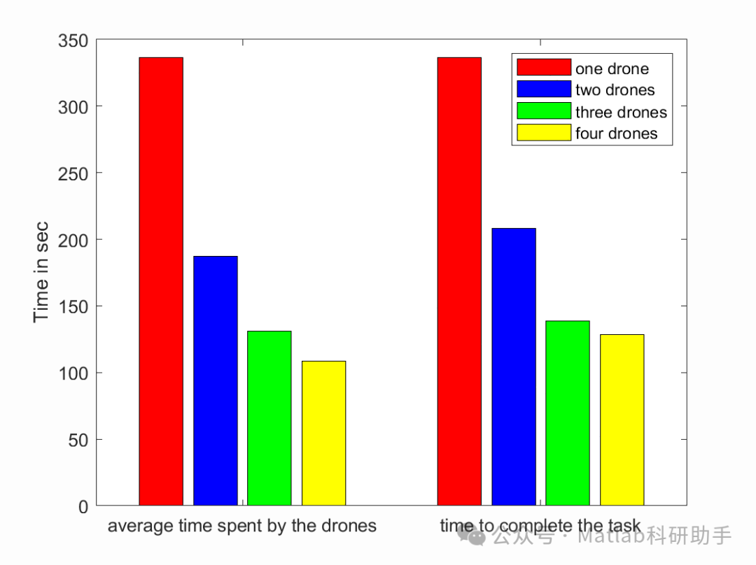
⛳️ Operation Results
🔗 References
[1] Meng Yang. Wireless Resource Allocation in Drone-Assisted AR Applications [D]. Nanjing University of Posts and Telecommunications, 2020.
[2] Meng Yang. Wireless Resource Allocation in Drone-Assisted AR Applications [D]. Nanjing University of Posts and Telecommunications [2025-08-22].
[3] Chen Qiang, Liu Caixia, Li Lingshu. Dynamic Resource Scheduling Strategy for 5G Network Slicing Based on Improved Greedy Algorithm [J]. Journal of Network and Information Security, 2018, 4(7):9. DOI:CNKI:SUN:WXAQ.0.2018-07-007.
📣 Partial Code
🎈 Some theoretical references are from online literature; if there is any infringement, please contact the author for deletion.
👇 Follow me to receive a wealth of Matlab e-books and mathematical modeling materials
🏆 Our team specializes in guiding customized Matlab simulations in various research fields, helping to realize research dreams:
🌈 Various intelligent optimization algorithms improvement and application
Production scheduling, economic scheduling, assembly line scheduling, charging optimization, workshop scheduling, departure optimization, reservoir scheduling, three-dimensional packing, logistics site selection, cargo location optimization, bus scheduling optimization, charging pile layout optimization, workshop layout optimization, container ship loading optimization, pump combination optimization, medical resource allocation optimization, facility layout optimization, visual domain base station and drone site selection optimization, knapsack problem, wind farm layout, time slot allocation optimization, optimal distributed generation unit allocation, multi-stage pipeline maintenance, factory-center-demand point three-level site selection problem, emergency supply distribution center site selection, base station site selection, road lamp post arrangement, hub node deployment, transmission line typhoon monitoring devices, container scheduling, unit optimization, investment portfolio optimization, cloud server combination optimization, antenna linear array distribution optimization, CVRP problem, VRPPD problem, multi-center VRP problem, multi-layer network VRP problem, multi-center multi-vehicle VRP problem, dynamic VRP problem, two-layer vehicle routing problem (2E-VRP), electric vehicle routing problem (EVRP), hybrid vehicle routing problem, mixed flow shop problem, order splitting scheduling problem, bus scheduling optimization problem, flight shuttle vehicle scheduling problem, site selection path planning problem, port scheduling, port bridge scheduling, parking space allocation, airport flight scheduling, leak source localization.
🌈 Machine learning and deep learning time series, regression, classification, clustering, and dimensionality reduction
2.1 BP time series, regression prediction, and classification
2.2 ENS voice neural network time series, regression prediction, and classification
2.3 SVM/CNN-SVM/LSSVM/RVM support vector machine series time series, regression prediction, and classification
2.4 CNN|TCN|GCN convolutional neural network series time series, regression prediction, and classification
2.5 ELM/KELM/RELM/DELM extreme learning machine series time series, regression prediction, and classification
2.6 GRU/Bi-GRU/CNN-GRU/CNN-BiGRU gated neural network time series, regression prediction, and classification
2.7 Elman recurrent neural network time series, regression prediction, and classification
2.8 LSTM/BiLSTM/CNN-LSTM/CNN-BiLSTM long short-term memory neural network series time series, regression prediction, and classification
2.9 RBF radial basis function neural network time series, regression prediction, and classification
2.10 DBN deep belief network time series, regression prediction, and classification
2.11 FNN fuzzy neural network time series, regression prediction
2.12 RF random forest time series, regression prediction, and classification
2.13 BLS broad learning system time series, regression prediction, and classification
2.14 PNN pulse neural network classification
2.15 Fuzzy wavelet neural network prediction and classification
2.16 Time series, regression prediction, and classification
2.17 Time series, regression prediction, and classification
2.18 XGBOOST ensemble learning time series, regression prediction, and classification
2.19 Transform various combinations time series, regression prediction, and classification
Covering wind power prediction, photovoltaic prediction, battery life prediction, radiation source identification, traffic flow prediction, load prediction, stock price prediction, PM2.5 concentration prediction, battery health status prediction, electricity consumption prediction, water body optical parameter inversion, NLOS signal identification, subway stop precise prediction, transformer fault diagnosis.
🌈 In image processing
Image recognition, image segmentation, image detection, image hiding, image registration, image stitching, image fusion, image enhancement, image compressed sensing.
🌈 In path planning
Traveling salesman problem (TSP), vehicle routing problem (VRP, MVRP, CVRP, VRPTW, etc.), three-dimensional path planning for drones, drone collaboration, drone formation, robot path planning, grid map path planning, multimodal transport problems, electric vehicle routing problem (EVRP), two-layer vehicle routing problem (2E-VRP), hybrid vehicle routing problem, ship trajectory planning, full path planning, warehouse patrol.
🌈 In drone applications
Drone path planning, drone control, drone formation, drone collaboration, drone task allocation, drone secure communication trajectory online optimization, vehicle collaborative drone path planning.
🌈 In communication
Sensor deployment optimization, communication protocol optimization, routing optimization, target localization optimization, Dv-Hop localization optimization, Leach protocol optimization, WSN coverage optimization, multicast optimization, RSSI localization optimization, underwater communication, communication upload and download allocation.
🌈 In signal processing
Signal recognition, signal encryption, signal denoising, signal enhancement, radar signal processing, signal watermark embedding and extraction, EMG signals, EEG signals, signal timing optimization, ECG signals, DOA estimation, encoding and decoding, variational mode decomposition, pipeline leakage, filters, digital signal processing + transmission + analysis + denoising, digital signal modulation, bit error rate, signal estimation, DTMF, signal detection.
🌈 In power systems
Microgrid optimization, reactive power optimization, distribution network reconstruction, energy storage configuration, orderly charging, MPPT optimization, household electricity.
🌈 In cellular automata
Traffic flow, crowd evacuation, virus spread, crystal growth, metal corrosion.
🌈 In radar
Kalman filter tracking, trajectory association, trajectory fusion, SOC estimation, array optimization, NLOS identification.
🌈 In workshop scheduling
Zero-wait flow shop scheduling problem (NWFSP), Permutation flow shop scheduling problem (PFSP), Hybrid flow shop scheduling problem (HFSP), zero idle flow shop scheduling problem (NIFSP), distributed permutation flow shop scheduling problem (DPFSP), blocking flow shop scheduling problem (BFSP).
👇