Commercial drones have begun to be used for detecting oil drilling towers and crops. However, they still require skilled manual operation; even semi-automated drones often need pre-made maps or data imported via wireless connections.
Researchers from the Swiss Federal Institute of Technology in Zurich are creating more autonomous drones. They have demonstrated that a small drone can create a three-dimensional map of unfamiliar areas with minimal human assistance, subsequently designing spatial routes and avoiding obstacles automatically.
“This is our first demonstration of complete mapping on a drone, reorganizing—finding the drone on the map—and designing routes,” said researcher Michael Burri, who is working on the project. The combination of software and sensors makes it easier to use drones for monitoring oil drilling towers, he mentioned. Companies need to manually perform a flight to create the map initially, after which it can operate automatically.
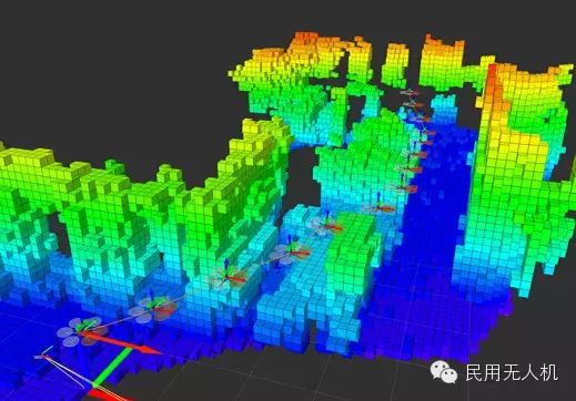
The drone uses the three-dimensional map to design the most efficient routes.
This team utilized a small quadcopter, the AscTec Firefly, weighing one kilogram, equipped with a panoramic camera and sensors to measure speed, direction, and gravity. They tested the software by flying in the site of a previously abandoned factory, which had a complex network of pipes and other factory equipment.
The drone’s adaptation to new spaces requires human assistance. While the operator helps it explore, the drone’s software builds a three-dimensional map by comparing data from motion and direction sensors with images captured by the camera.
The depth images captured by the camera are used to construct the three-dimensional map; areas where the drone cannot fly are masked. Once the map is complete, the drone can design the shortest route to the target, avoiding any identified obstacles.
This mapping with sensing technology has been demonstrated before, but not applied together inside a drone, said Wolfram Burgard, a professor at the University of Freiberg in Germany. “This brings tighter connections to applications for observing the real world,” he mentioned at the International Conference on Intelligent Robots and Systems. Burgard is the chief editor of the related paper.
However, giving such strong mapping capabilities to a small drone comes at a high cost. After being equipped with the necessary computers and sensors, the drone can only remain airborne for seven minutes, compared to fifteen minutes previously. Burri stated that improving the drone’s design means this is not a significant issue, as new drones on the market can extend this time to twenty minutes under the same configuration.
He and other researchers are currently studying how to enable drones to avoid colliding with moving objects that do not appear on the map—such as humans or mobile devices.
This article is sourced from: Machine Heart
Daily updates on drone news and insights!
Long press the QR code to follow us!