Recommended public account to follow ↓
In a previous article, “The Explosion of Direct Satellite Connections for Mobile Phones! Weijie Chuangxin May Become the Big Winner,” I received many private messages from readers. Since everyone is so interested, I will continue to discuss the topic of Satellite IoT.
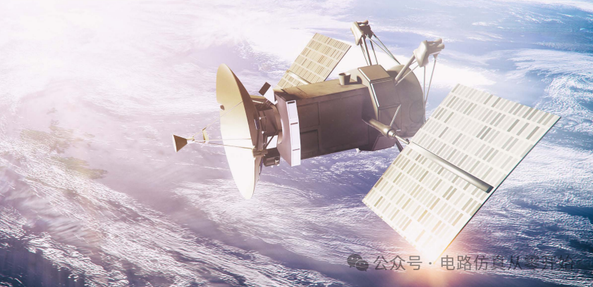
Although cellular data can be received in every corner of the city, and even on high-speed trains, the signal is almost completely covered. But did you know? Currently, only about 10% of the Earth’s surface can access ground communication services, while the vast areas left — whether remote farmland, ocean-going vessels, or power facilities in deep mountains — need a technology to break the barriers of connectivity, which is Satellite IoT, and one of the core architectures supporting it is Non-Terrestrial Networks (NTN). This technology not only reduces wireless communication costs but also expands the connection range globally, allowing many previously “disconnected” scenarios to have new possibilities.
Satellite IoT is not meant to replace ground cellular networks but serves as an important supplement — especially in areas where ground networks cannot reach, it can become a critical connection link. Now, whether it is established satellite operators or emerging technology teams, they are all eyeing this market, as industries such as agriculture, maritime transport, oil and gas exploration, and power operation and maintenance urgently need global IoT connectivity. To achieve this, one must first understand the “space infrastructure” that supports Satellite IoT — that is, the satellites operating in different orbits.
█ Low/Medium/High Orbit Satellites
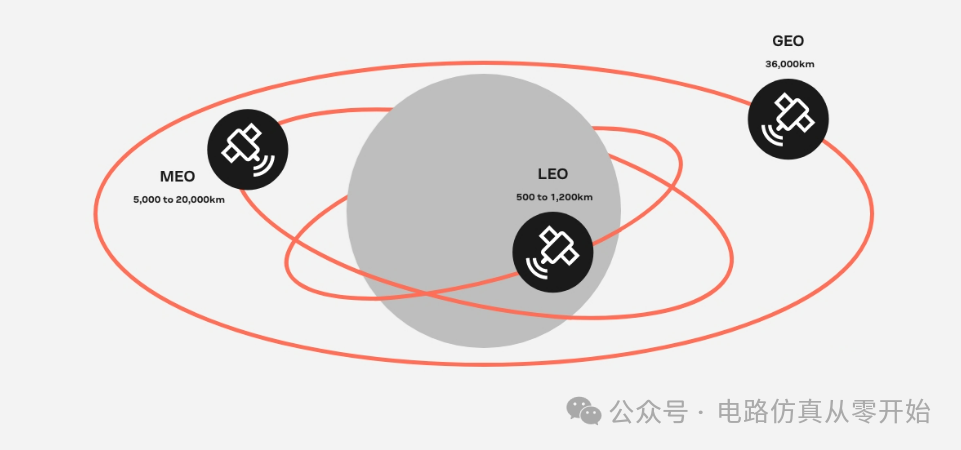
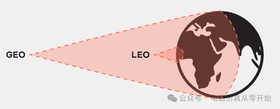
These satellites are mainly divided into three categories: Geostationary Earth Orbit (GEO), Medium Earth Orbit (MEO), and Low Earth Orbit (LEO). Their orbital heights, coverage areas, and purposes vary greatly. GEO satellites operate at an altitude of about 36,000 kilometers, synchronized with the Earth’s rotation speed, so they appear “stationary” from the ground, and ground antennas do not need to frequently adjust their direction to align with them. A single GEO satellite can cover one-third of the Earth’s surface area, and just three can cover most of the land. Early satellite communications relied heavily on them, such as broadcasting, weather forecasting, and satellite radio, which commonly used GEO satellites. However, its drawbacks are also evident; the long distance from the ground leads to high latency, and if there are east-west canyons, mountains may block the signal, affecting service.
LEO satellites operate at much lower altitudes, typically between 500 and 1200 kilometers, completing an orbit around the Earth in about 128 minutes, making 12 orbits a day. Because they are closer to the ground, their latency is very low, even approaching the experience of ground fiber optics, and the device transmission power is similar to traditional cellular devices. However, LEO satellites have a small coverage area; a single satellite can only cover a small region of the Earth, and to achieve global continuous coverage, hundreds of satellites must form a “constellation”. Projects like OneWeb and Starlink are building large LEO constellations. Of course, LEO also faces many challenges; the high-speed movement of satellites requires terminals to track their positions in real-time and compensate for Doppler shift (the change in signal frequency due to the relative motion of the satellite and the ground), and terminals may have to wait for the satellite to pass overhead before sending messages, leading to fluctuating message delays.
MEO satellites have orbital heights between GEO and LEO, approximately 5000 to 20000 kilometers. They do not need to have fixed orbits like GEO and can flexibly choose their paths around the Earth, covering a larger area than LEO and enhancing coverage by interconnecting with other satellites. However, to build an effective MEO communication network, typically more than twenty satellites are needed, and ground antennas must continuously track the satellite’s position, so they are more commonly used in navigation fields — for example, the European Galileo system and the American Global Positioning System (GPS) rely on MEO satellites for precise positioning, from tracking airplanes to mobile phone navigation.
█ Communication Frequency Bands (L/S/Ku/K Bands)
Different orbiting satellites need to rely on specific frequency bands to communicate with the ground, and the choice of these bands directly affects the communication rate, coverage area, and application scenarios. The International Telecommunication Union (ITU) is responsible for allocating radio frequencies for satellite use, and different bands have different purposes. For example, the VHF band (frequency 30-300MHz) is commonly used on CubeSats, supporting amateur satellite activities and some military and aviation applications; the UHF band (300MHz-1GHz) is mostly used for communication satellites and meteorological satellites; the L band (1-2GHz) is one of the “main frequency bands” for Satellite IoT, used by organizations like Inmarsat and ORBCOMM, suitable for low-bandwidth scenarios such as satellite phones, LEO systems, and IoT devices, and navigation systems also commonly use this band; the S band (2-4GHz) is adopted by operators like Globalstar and Iridium for communication satellites and meteorological radars.

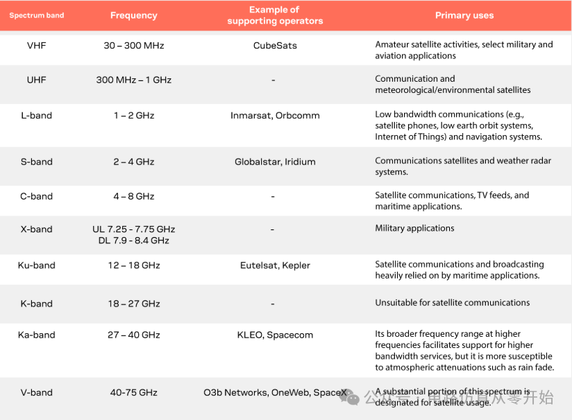
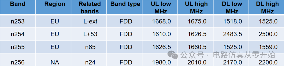
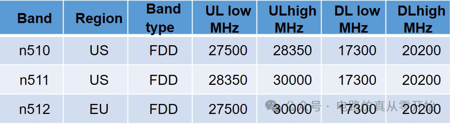
Currently, the industry’s demand for high data rates is increasing, leading to a shift towards higher frequency bands (such as the Ka band), but high-frequency signals suffer more severe attenuation, with lower signal-to-noise ratios (SNR), requiring stronger transmission power and more expensive directional antennas, making them more suitable for broadband services and less suitable for low-bandwidth IoT scenarios. For IoT, the L band, S band, C band, and X band are more commonly used choices, as they do not require very high power and can meet the communication needs of most IoT devices. The entire NTN frequency band has gradually improved from 3GPP Release 15 to the current R19, mainly divided into three bands:
█ FR1: NTN bands
█ FR2-1N (R18):17.3 – 52.6GHz
█ FR3 Ku Band (R19)

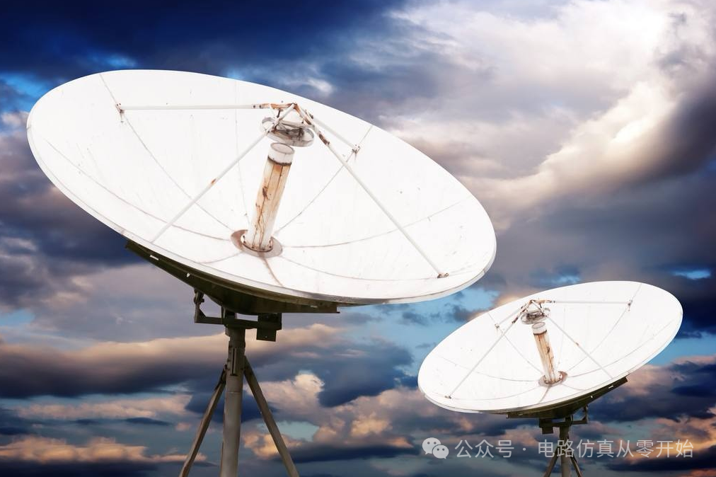
Regardless of the type of satellite, to transmit signals to the ground and be used by users, a set of ground and space collaborative mechanisms is required. IoT devices equipped with satellite antennas will send the data collected by sensors to the satellite while receiving control instructions from the satellite; on the ground, satellite antennas (commonly known as “satellite dishes”) serve as data reception points, integrating the information sent by the satellite into the ground network and then transmitting this data to internet data centers, ultimately allowing users to view and use this data on their terminals. In simple terms, from the ground perspective, the operational logic of different satellites is not much different; the choice of which satellite to use mainly depends on whether its orbital position meets the specific scenario’s needs.
Currently, there are many satellite communication systems using proprietary protocols on the market, which are technically mature and have a large user base. For example, Iridium’s LEO satellite constellation operates at an altitude of 780 kilometers, providing voice and data services; Inmarsat’s GEO satellites at 36,000 kilometers support maritime, aviation, and other fields; ORBCOMM has both GEO and LEO satellites, with GEO satellites at 36,000 kilometers and LEO satellites at 750 kilometers, mainly transmitting data; Globalstar’s LEO satellites operate at an altitude of 1400 kilometers, providing voice and data services using S and L bands. Some of these systems are particularly adapted for IoT scenarios, such as ORBCOMM’s IsatData Pro (IDP) service, which relies on Inmarsat’s GEO satellites to achieve bidirectional text and data transmission, with a maximum message size of 10KB sent to devices and 6.4KB received from devices, with an average delivery time of 15 seconds, making it very suitable for critical scenarios like fleet management, fishing vessel monitoring, and oil and gas operations.
However, beyond these proprietary systems, there is a more significant trend in the industry — NTN technology based on 3GPP standards. 3GPP is the organization that sets cellular communication standards, and to promote the integration of satellite communication and cellular networks, it has adapted 5G New Radio (NR), Narrowband IoT (NB-IoT), and LTE for Machine-Type Communications (LTE-M) for satellite connections, referred to as NR-NTN and IoT-NTN (collectively known as NTN). This standard was finalized in 2022, so the complete NTN ecosystem is still under construction — satellite operators need to deploy constellations, negotiate landing rights with various countries, discuss roaming agreements with cellular operators, and chip manufacturers are also advancing the certification of IoT chips that meet the standards, all of which take time.
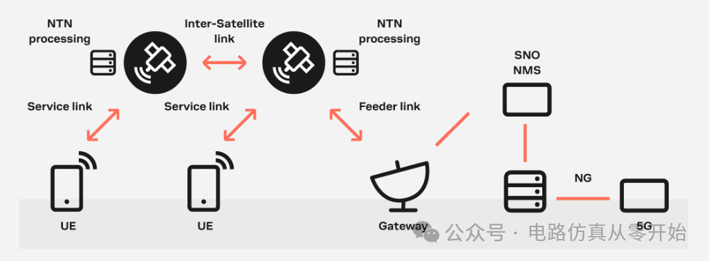
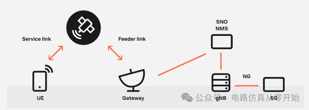
3GPP NTN mainly targets consumer and industry-level satellite communication services, supporting various satellite constellations such as LEO (above 600 kilometers) and GEO, and defines two core architectures. One is the transparent architecture, where the base station (gNB, 5G base station) is located behind the ground gateway, and the satellite mainly acts as a “repeater”, responsible only for radio frequency (RF) processing, such as frequency conversion, signal amplification, and beam management, without complex data processing; the other is the regenerative architecture, where the satellite carries a complete base station or some components (such as radio units), allowing it to decode and process data directly on the satellite, making the connection between the satellite and the ground (called the “feeder link”) more like a terrestrial backhaul network, not necessarily relying on 5G NR technology, and supporting inter-satellite links, providing greater flexibility and coverage capability.
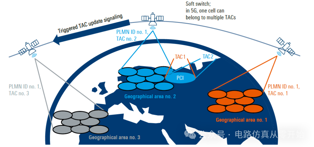
To reduce the “handoff frequency” when terminals use satellites, current satellite systems also employ “Earth-fixed beam” technology. Satellites divide the service area into multiple “spot beams”, each beam corresponds to a “cell” similar to a cellular network with a diameter of several tens to hundreds of kilometers. If the beam follows the satellite’s movement, ground terminals will frequently switch between different cells (i.e., “handoff”); however, Earth-fixed beams allow satellites to continuously point the beams at a specific area on the ground, enabling terminals to stay in the same cell for several minutes, significantly reducing the number of handoffs. The 3GPP Release 17 standard supports both beam modes, but Earth-fixed beams are clearly more suitable for scenarios requiring stable connections.
One of the biggest challenges of satellite communication is latency and Doppler shift. The former comes from the long distance between the satellite and the ground, while the latter is the change in signal frequency caused by satellite movement — for example, during high-speed movement of LEO satellites, the Doppler shift can reach up to 25ppm (parts per million), equivalent to a 50kHz shift at a 2GHz carrier frequency. Moreover, within the same cell, the distance between different terminals and the satellite varies, leading to a maximum “differential delay” of 10 milliseconds. To address this issue, 3GPP requires user equipment (UE, such as IoT terminals) to first download the satellite’s broadcast ephemeris (which contains the satellite’s position and velocity information), then use its own Global Navigation Satellite System (GNSS) receiver to determine its position, calculate the distance and relative speed to the satellite, and pre-compensate for frequency shifts and time differences. This way, the base station can operate at the original frequency, and the uplink and downlink timing can be aligned, providing an experience closer to that of terrestrial networks. However, the long latency of satellite communication still requires adjustments to scheduling mechanisms; for example, the round-trip time (RTT) originally designed for terrestrial networks to be under 1 millisecond must be redefined in NTN to accommodate longer delays.
The differences between NTN and terrestrial networks are also reflected in “mobility”. For LEO constellations, even if the terminal is stationary, the satellite’s orbit around the Earth will cause the terminal to frequently switch cells; whereas in terrestrial networks, the signal strength of the terminal mainly depends on the distance from the base station, in NTN, all terminals are approximately equidistant from the satellite, leading to minimal differences in signal strength between the center and edge of the cell, which means that the logic of selecting cells based on signal strength in traditional cellular networks needs to be adjusted in NTN.
For IoT, NTN also has a unique advantage — supporting “discontinuous coverage”. Many IoT scenarios do not require terminals to be online all the time, such as transmitting soil moisture data every few hours or reporting the position of ocean-going vessels once a day. In this case, even if the number of satellites in the satellite constellation is small (i.e., a “sparse constellation”), terminals can calculate when they will receive satellite signals based on the ephemeris and coverage information broadcast by the satellite, and transmit data at the scheduled time without having to wait continuously. The IoT-NTN in 3GPP Rel 17 is specifically adapted for such scenarios, allowing sparse constellations to support IoT applications.
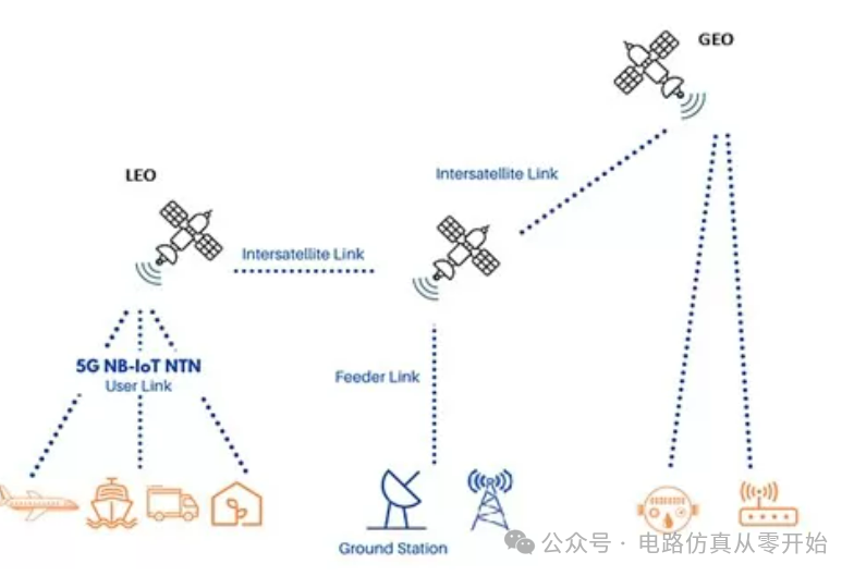
So, what value does Satellite IoT bring to device manufacturers and industry developers? First, its application scenarios are very broad; as long as devices appear in areas not covered by ground networks or require backup connections, Satellite IoT can be used. For example, asset tracking, where terminals use low-cost cellular connections in areas with cellular coverage and automatically switch to satellite when entering remote areas, achieving global real-time monitoring; remote substations in the power industry use cellular networks to transmit data, and when natural disasters disrupt ground networks, satellites can serve as backups to ensure uninterrupted power grid monitoring; agricultural drone inspections and soil sensors can also rely on satellites to send data back to the cloud without depending on ground base stations.。
Currently, Satellite IoT that meets the 3GPP Rel 17 NTN standard is gradually being implemented, with constellation deployment, roaming protocol negotiations, and chip certification all in progress. Before this, those mature proprietary satellite systems remain important choices in the industry. Companies like u-blox have already launched solutions that bridge the current and future — their SARA-S5 series multimode modules, based on their self-developed UBX-R52 platform, include models that meet the 3GPP Rel 17 IoT-NTN standard (such as SARA-S528NM10) and models that support LTE-M cellular connections and are compatible with ORBCOMM satellite connections (such as SARA-S520BM10), meeting the satellite IoT needs at different stages.
In the past, the cost of multimode (cellular + satellite) connections was too high for many scenarios to afford, but now the situation has changed — not only are module costs decreasing, but multimode technology also allows terminals to “smart switch”: using inexpensive cellular networks most of the time and switching to satellite when needed, significantly reducing overall communication costs. This is undoubtedly good news for industries that require global coverage or ensure business continuity.
From supplementing ground networks to becoming a core connection method in critical scenarios, Satellite IoT is leveraging the development of NTN technology and multimode modules to turn the concept of “global seamless connectivity” into reality. In the future, as more standard-compliant satellite constellations are deployed and the costs of chips and modules decrease further, we may see that whether it is deep-sea research vessels or polar research stations, they can easily connect to the network just like mobile phones in cities — this is the ultimate value of Satellite IoT + NTN: ensuring that no inch of the Earth is left “disconnected”.
After reading this, do you have many opinions to share? Feel free to leave a comment~~ END
END