





How to Achieve Dynamic Monitoring of Forestry Resources (Forests, Wetlands, Wildlife) Using Satellite Remote Sensing, Drones, and IoT Devices?
1
Satellite Remote Sensing: Large-Scale Periodic Monitoring
1. Application Scenarios
Forest Cover Change: Monitoring deforestation, afforestation, and other land use changes.
Wetland Hydrological Dynamics: Tracking water level changes and vegetation degradation (e.g., mangrove reduction).
Wildlife Habitat Assessment: Analyzing habitat quality through NDVI (Normalized Difference Vegetation Index).
2. Technical Solutions
Multi-source Satellite Data Fusion:
Optical Remote Sensing (e.g., Landsat, Sentinel-2): Provides high-resolution spectral data (10-30 meters) for vegetation classification and health assessment.
Radar Remote Sensing (e.g., Sentinel-1): Monitors surface deformation (e.g., illegal logging traces) through cloud penetration.
High-Resolution Satellites (e.g., WorldView): Identifies changes at the individual tree level (accuracy up to 0.3 meters).
3. AI Analysis:
Deep learning models (e.g., U-Net) automatically extract forest boundaries and wetland extents.
Time-series analysis (e.g., Google Earth Engine) detects abnormal changes (e.g., post-fire recovery).
4. Advantages and Limitations
Advantages: Global coverage, rich historical data (back to over 30 years).
Challenges: Cloud interference, revisit cycle limitations (e.g., Sentinel-2 has a 5-day cycle).
2
Drones: High-Precision Flexible Supplementation
1. Application Scenarios
Small-Scale Precision Monitoring: Evidence collection at illegal logging sites, endangered plant population surveys.
Disaster Emergency: Real-time thermal imaging in fire zones (equipped with infrared cameras), localized pest outbreak assessments.
Complex Terrain Areas: Monitoring in satellite blind spots such as steep slopes and marshes.
2. Technical Solutions
Sensor Configuration:
Multispectral Cameras (e.g., Parrot Sequoia+): Identifying tree species and chlorophyll content (health status).
LiDAR: Generating 3D point clouds to measure stand density and volume.
Oblique Photography: Constructing centimeter-level real-world models (for micro-topography analysis of wetlands).
Autonomous Flight and AI Processing:
Pre-set flight paths for automatic flying (e.g., DJI Terra planning).
Edge computing for real-time target recognition (e.g., YOLO algorithm for wildlife detection).
3. Advantages and Limitations
Advantages: Resolution up to centimeter level, flexible response.
Challenges: Short endurance (usually <1 hour), regulatory restrictions (no-fly zones).
3
IoT Devices: Real-Time Ground Data Collection
1. Application Scenarios
Micro-Environment Monitoring: Temperature and humidity in forest areas, soil moisture, CO₂ concentration.
Wildlife Tracking: Activity tracking of flagship species (e.g., Siberian tiger) wearing GPS/Beidou collars.
Human Interference Early Warning: Acoustic sensors identifying chainsaw sounds and poaching gunshots.
2. Technical Solutions
Sensor Network:
Wireless Sensor Nodes (LoRa/NB-IoT): Low-power transmission of data to base stations.
Smart Camera Traps: AI-triggered photography (activated upon animal detection).
Underground Sensors: Monitoring root growth and soil carbon sinks.
Edge Computing:
Local data preprocessing (e.g., filtering invalid alarms) to reduce transmission load.
Communication and Energy:
Solar power supply + low-power design (e.g., ESP32 chip).
Hybrid networking (4G/Beidou short message coverage in no-signal areas).
3. Advantages and Limitations
Advantages: High real-time performance (minute-level updates), rich data dimensions.
Challenges: Equipment maintenance costs, extreme environmental (low temperature/humidity) tolerance.
4
Multi-Source Data Fusion and Platform Construction
1. Key Technologies
Spatiotemporal Alignment: Unifying satellite (low-frequency large-scale), drone (medium-frequency local), and IoT (high-frequency single-point) data onto the same GIS platform (e.g., ArcGIS, SuperMap).
Model Coupling:
Satellite macro trends + drone detail verification + IoT real-time calibration.
Example: Satellite detects NDVI anomaly → Drone investigates → IoT confirms pest outbreak.
Digital Twin: Constructing a 3D forest model to simulate the impact of climate change on resources.
2. Typical Cases
Forest Fire Early Warning System:
Satellite thermal infrared monitoring of high-temperature points → Drone confirms fire point location → IoT weather station predicts fire spread.
Wetland Protection:
Satellite identifies water level drop → Drone inspects illegal water extraction points → IoT water level sensors trigger alarms.
5
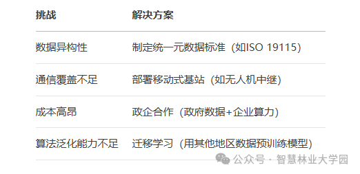
Challenges and Countermeasures
Future Directions
Star-Machine-Person Collaboration: Coordinating drones through satellites, guiding forest rangers, forming a closed-loop response.
AI Lightweighting: Deploying models to edge devices (e.g., drone-mounted chips).
Citizen Science: Encouraging the public to upload ecological data captured by mobile phones.
【Disclaimer】We respect originality and emphasize sharing. Some content in this account is sourced or adapted from official websites, media networks, and other public platforms, with copyright belonging to the original authors. The content is for learning and reference only. If your rights or copyrights are infringed, please contact us for removal.

Smart Forestry University Garden Editorial Department
Editor-in-Chief|Cao Qiqige
Deputy Editors|Yu Lintong, Duan Jiali
Editorial Board|Yang Fei、Li Huan, Liu Hao, Wei Fanghao
Technical Service Contact
Zhao Xiuping 15301315317
(Some images sourced from the internet, infringement will be deleted)