From “Base Station Walls” to “Satellite-Based Territories” – The Global Centimeter-Level Positioning Supremacy of WAPPS-PPP-IAR is Established.
The global high-precision positioning field is undergoing a profound technological transformation and industrial restructuring. In the face of the limitations of traditional positioning technologies in terms of coverage, accuracy, and scene adaptability, Kepler Satellite has successfully developed and launched the Wide Area Precise Positioning System (WAPPS) based on cutting-edge PPP-IAR technology, strategically breaking geographical boundaries and injecting new momentum into key areas such as precision agriculture, marine surveying, and autonomous driving, leading centimeter-level positioning services into a new era.
“In the vast cotton fields of Xinjiang, autonomous tractors equipped with BeiDou navigation move straight along the ridges, sowing cotton seeds with an error of no more than 2.5 centimeters. In the carrot base of Shaanxi, the application of the BeiDou navigation unmanned driving system has increased efficiency by more than ten times. However, these precision agricultural devices that rely on ground-based enhancement networks experience significant reductions in positioning accuracy once they enter deserts, oceans, or remote mountainous areas.
Traditional RTK technology heavily relies on ground reference station networks (CORS), and when operating in areas far from station coverage, accuracy and reliability significantly decrease. This limitation is particularly prominent in fields such as precision agriculture, resource exploration, and ocean navigation that require global operations.
But the combination of BeiDou navigation and satellite-based enhancement services is bringing precise positioning capabilities to every corner of the Earth.”
1The Dilemma of Traditional TechnologiesRTK and PPP
With the development of Global Navigation Satellite Systems (GNSS), the demand for real-time centimeter-level positioning is becoming increasingly urgent in fields such as autonomous driving, precision agriculture, and marine surveying, leading to the emergence of two different technological directions: traditional RTK (Real-Time Kinematic) and PPP (Precise Point Positioning).
RTK utilizes double-difference observations between nearby reference stations and mobile stations to achieve real-time centimeter-level positioning by eliminating most sources of error, but its accuracy and reliability heavily depend on nearby base stations and stable data links. As the distance from the base station increases, RTK accuracy rapidly declines, and the communication burden increases. In contrast, PPP can achieve centimeter-level positioning accuracy using a single receiver combined with precise orbit and clock corrections, but the initial convergence time can take 15 to 30 minutes. Both have their advantages and disadvantages, as shown below:
RTK Technology
✅ Instant centimeter-level accuracy
❌ Relies on local base station networks, limited coverage
❌ Requires continuous internet/radio transmission of differential data
PPP Technology
✅ Global coverage with a single receiver
❌ Convergence time of up to 30 minutes
❌ Difficult to meet real-time operational needs
Summary of Pain Points: Accuracy and coverage cannot be achieved simultaneously, remote areas and mobile scenarios become “positioning blind spots.”
2DisruptorsComparison of Three Innovative Technologies
To address the issues faced by PPP and RTK, several innovative technologies that combine the advantages of both have emerged, such as PPP-AR, PPP-IAR, and PPP-RTK. PPP-AR enhances positioning accuracy based on traditional PPP by fixing the carrier phase ambiguity (Ambiguity Resolution, AR). The ambiguity in traditional PPP is a floating-point solution, while PPP-AR fixes the ambiguity to an integer by correcting fractional cycle bias (FCB) and uncalibrated phase delay (UPD), thereby improving convergence speed and positioning accuracy.
PPP-IAR (Integer Ambiguity Resolution, IAR) is a non-differential integer solution satellite orbit determination method based on carrier distance, which eliminates non-differential whole-cycle ambiguity parameters at a single station through network estimation of phase fractional bias, achieving fixed ambiguity. It is flexible in implementation, highly efficient in computation, and can simultaneously obtain integer clock products from multiple systems, assisting single-station users in achieving PPP-AR. PPP-RTK integrates PPP and RTK, achieving rapid (even instantaneous) centimeter-level positioning accuracy over a wide area with a single receiver through the fusion of state space representation (SSR) and regional enhancement correction information. We compare these three innovative technologies across several dimensions to provide a clearer view of their advantages and disadvantages.Comparison as follows:
 3Kepler WAPPSThe Pinnacle of PPP-IAR Technology
Kepler Satellite, relying on the continuous exploration and innovation at the forefront of the field by the Satellite Navigation and Positioning Technology Research Center of Wuhan University, has integrated the Wide Area Precise Positioning System (WAPPS) based on PPP-IAR, which is a GNSS differential service system aimed at users with real-time high-precision positioning and navigation needs, featuring the following characteristics:
-
Broadcasts real-time correction data to ensure users achieve precise single-point positioning
-
Low density and few ground stations, wide service area, diverse services, and simple user terminals
-
Aimed at high-precision applications in marine transportation, surveying, and precision agriculture
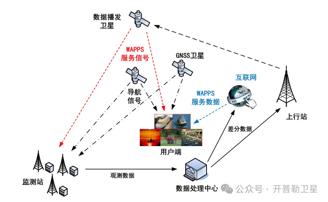
Illustration of Kepler’s Satellite-Based High-Precision Positioning Service
Three Disruptive Advantages:
-
National Coverage
-
Broadcasts via dual links of cellular IP network + satellite, covering oceans/deserts/mountains
-
Compared to traditional PPP-RTK: Completely free from base station dependence
-
3-Minute Rapid Convergence
-
Utilizes multi-frequency ambiguity fixing strategy, speed crushing traditional PPP (30 minutes)
-
Measured data: Horizontal accuracy 1.5cm, vertical accuracy 3cm
-
Anti-Interference Black Technology
-
Breaks through ionospheric disturbance bottlenecks, outputting centimeter-level positioning
-
Maintains 5 minutes of accuracy after signal interruption (essential for forest/tunnel scenarios)
4Kepler K1000Laser Pointing, Measurement Achieved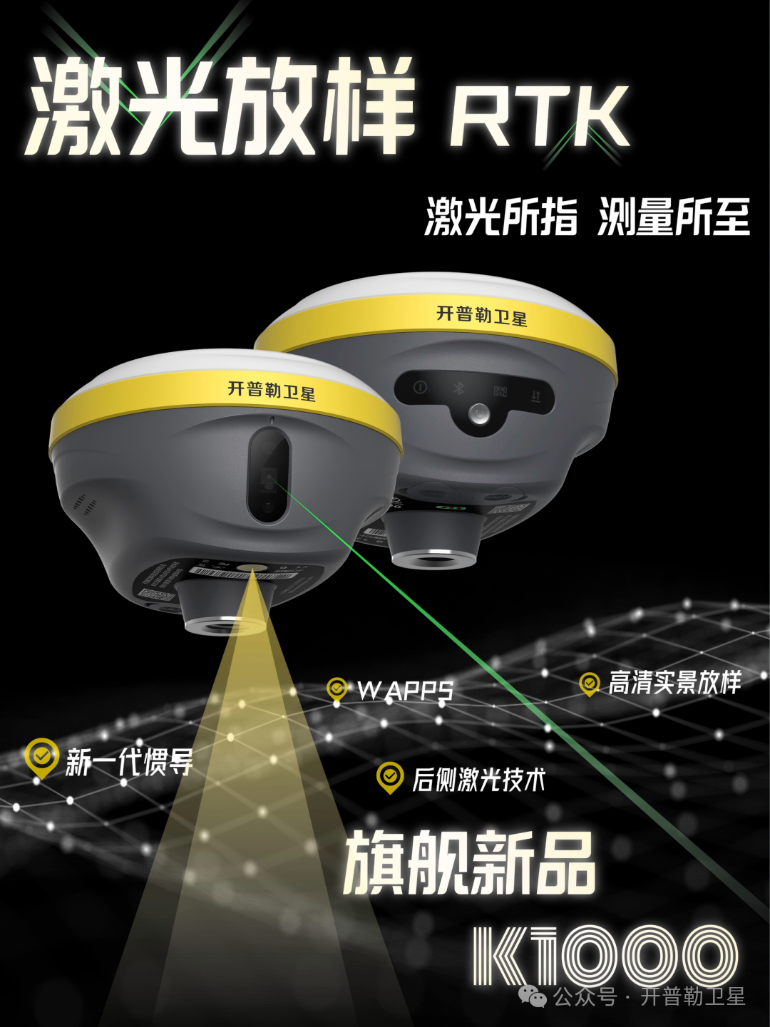
Hardcore Configuration Empowering WAPPS
-
“Inertial Navigation Without Sensing” Black Technology:60° large angle measurement without initialization, accurate even when the device is held upside down.
-
Starry Night Vision Trio:
✔ 3R level anti-strong light green laser (30m measurement)
✔ Millimeter-level laser module
✔ Star-level night vision HD camera
-
Ultra-Endurance Handheld:6600mAh battery + 5.45-inch screen, worry-free all-day field operations.
5OutlookKepler WAPPS Service
Precise positioning, no boundaries
From traditional RTK to satellite-based enhanced WAPPS services, the technological revolution in the positioning field is breaking geographical limitations, providing users with indiscriminate centimeter-level positioning services.
KWAPPS Service Features
-
Global Coverage:Based on PPP-IAR technology, usable in non-base station areas
-
Rapid Convergence:Achieves centimeter-level accuracy in 3 minutes
-
Continuous Positioning:Maintains 5 minutes of accuracy after signal interruption
-
Diverse Application Scenarios:Precision agriculture, marine surveying, autonomous driving, low-altitude economy, safety monitoring, and other industries
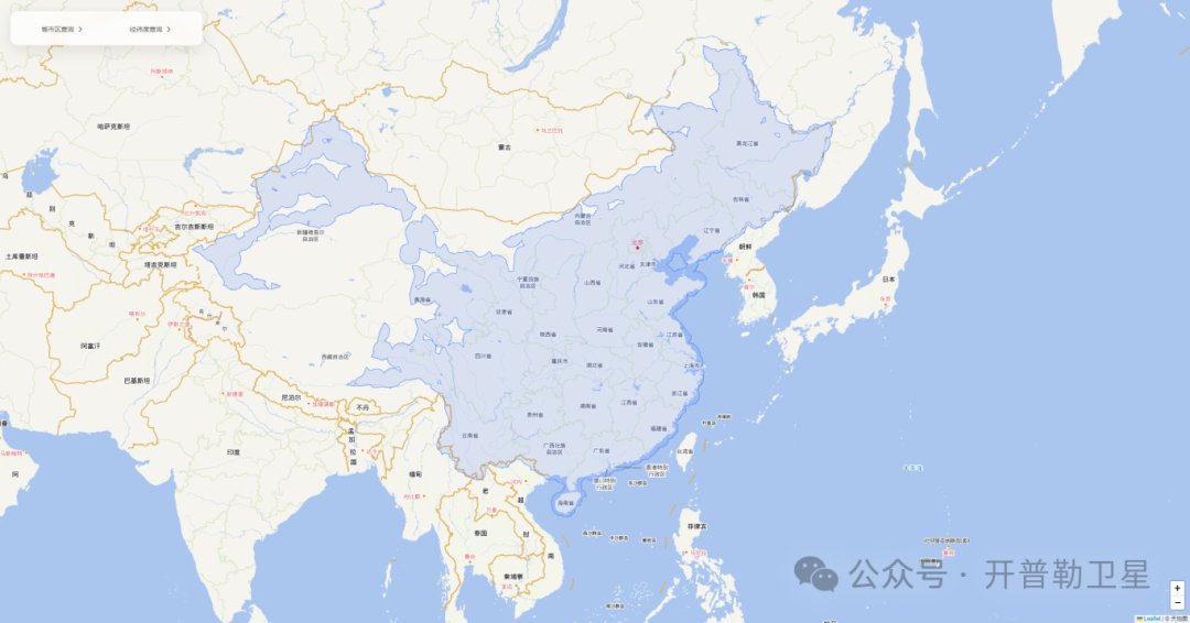
Coverage of Kepler’s Satellite-Based High-Precision Positioning Service
Source:Kepler Satellite