Article Title: Large-scale mapping of water bodies across sensors using unsupervised deep learning
Published Journal: Remote Sensing of Environment
Content Overview
1.Research Background and Issues
2.Core Method
3.Experimental Design and Results
4.Discussion and Conclusion
1. Research Background and Issues
·Importance of Water Body Monitoring: Rapid and accurate monitoring of surface water bodies is crucial for water resource management, environmental protection, and sustainable urban development.
·Data Foundation: Optical remote sensing data such as Landsat and Sentinel have high temporal and spatial resolution and are publicly available, making large-scale water body mapping feasible.
·Limitations of Existing Methods:
·Traditional threshold-based methods (e.g., NDWI, MNDWI) require threshold adjustments for different regions or sensors, are significantly affected by imaging conditions (e.g., lighting, atmosphere), and water body characteristics (e.g., suspended matter, vegetation), leading to poor generalization ability.
·Supervised classification methods (e.g., SVM, deep learning models) rely on a large number of high-quality labeled samples, while the complex morphology of water bodies (e.g., irregular boundaries, small water bodies) makes sample labeling time-consuming and weakens cross-sensor and cross-region adaptability.
2. Core Method: UUCP Framework
The paper proposes an unsupervised cross-sensor deep learning water body mapping framework (UUCP), which does not require manual labeling and enables water body extraction from unlabeled large-scale optical remote sensing images. The core consists of three parts: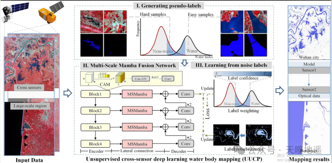
Figure 1. Proposed unsupervised cross-sensor deep learning water body mapping framework (UUCP)
1. Pseudo-label Generation (Unsupervised Multi-threshold Strategy)
·Sample Classification: Combining MNDWI and NDWI water body indices, distinguish between “certain water bodies” (easy samples, such as large lakes and main rivers) and “potential water bodies” (difficult samples, such as small lakes, narrow rivers, and boundary areas) using high threshold (Thigh) and low threshold (Tlow).
·Optimizing Pseudo-labels:
·Utilize the reflectance characteristics of near-infrared (NIR) bands (water body reflectance is lower than non-water bodies) to eliminate non-water pixels from potential water bodies.
·Combine water body index roughness (WIR) and spatial connectivity analysis (e.g., connected component labeling) to optimize pseudo-labels for boundary areas and small water bodies, reducing noise.
2. Channel Attention Multi-scale Mamba Fusion Network (CAMFNet)
·Network Structure: Includes an encoder (to extract hierarchical convolutional features) and a decoder (to restore spatial resolution).
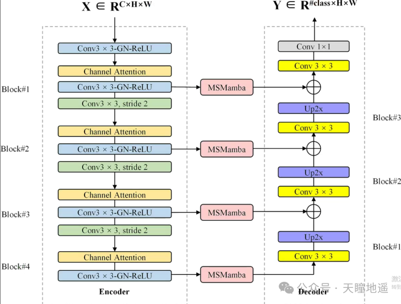
Figure 2. The architecture of CAMFNet.
·Key Modules:
·Channel Attention Module (CAM): Calculates channel weights through global average pooling and fully connected layers, highlighting feature channels critical for water body extraction.
·Multi-scale Mamba (MSMamba) Module:
·Dense multi-scale fusion: Extract multi-scale features through depthwise separable convolutions with different dilation rates, adapting to water bodies of various sizes.
·4D-SSM: Based on the Mamba model, scans images in both horizontal and vertical positive and negative directions to capture global spatial context information, overcoming the challenge of processing non-sequential spatial information in remote sensing images.
3. Noisy Label Learning Strategy
·Loss Re-weighting: Adjusts weights based on sample confidence (weights for “certain water bodies” and “certain non-water bodies” are 1, while weights for “potential water bodies” are dynamically calculated based on distance to the threshold), reducing the impact of noisy samples on training.
·Label Renovation: Statistics on sample prediction error rates; when the error rate exceeds a threshold, the label is flipped to correct noisy labels and enhance model generalization ability.
3. Experimental Design and Results
1. Experimental Data and Regions
·Research Areas: Guangzhou and Wuhan in China, and 9 regions in France (e.g., Bordeaux, Camargue), covering diverse water body types (large lakes, small water bodies, complex boundary rivers) and terrains (mountains, plains, deltas).
·Sensor Data: Sentinel-2 (10-20m resolution) and Landsat-8 (30m resolution) to validate cross-sensor adaptability.
2. Comparison Methods
Includes threshold methods (Otsu, Edge-Otsu), clustering methods (HC), machine learning methods (RF), and deep learning methods (Co-teaching, DeepWaterMap), etc.
3. Core Results
·Single Sensor Performance:
·On Sentinel-2 data, the average Kappa value of UUCP is 0.8859, significantly higher than other methods (e.g., 0.6944 for DeepWaterMap).
·On Landsat-8 data, the average Kappa value is 0.8084, better than HC (0.7576) and DeepWaterMap (0.7617).
·Cross-sensor Performance: The model trained on Landsat-8 directly predicts Sentinel-2 data, achieving an average Kappa of 0.8736, close to non-cross-sensor scene performance, validating strong generalization ability.
·Small Water Body Extraction: For small water bodies < 0.5ha, the Kappa value of UUCP is 0.716, outperforming other methods, demonstrating adaptability to complex scenarios.
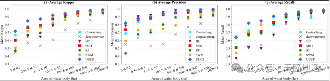
Figure 3. Extraction accuracy for different water body sizes. (a) Average Kappa of HC, RF, MBT, SWM, Co-teaching, DeepWaterMap, and UUCP for various water body sizes, (b) Average Precision, and (c) Average Recall.
4. Discussion and Conclusion
·Importance of Pseudo-labels: The pseudo-label strategy of UUCP (combining easy and difficult samples) improves the average Kappa by 0.1126 compared to the random sampling of traditional Otsu threshold methods, especially enhancing extraction accuracy for small water bodies and complex boundaries.
·Comparison with Existing Products: Outperforms global water body products such as Esri (average Kappa of 0.7813 for Sentinel-2 products) and JRC (average Kappa of 0.7366 for Landsat products).
·Conclusion: UUCP achieves cross-sensor, large-scale high-precision water body mapping through unsupervised pseudo-label generation, multi-scale feature learning, and noisy label processing, providing a new method for water resource monitoring. Future work may combine SAR data or cloud removal preprocessing to further enhance performance under complex weather conditions.