This article is an invitation from the “Journal of Soundscape Science” to the original author team.
With the trend of population aging, the threat of noise to the health of the elderly is increasing. In 2022, the United Nations Environment Programme (UNEP) proposed creating a more inclusive urban sound environment and recommended paying more attention to noise pollution affecting vulnerable urban groups. As one of the vulnerable groups in cities, the elderly, due to their physical limitations, have reduced mobility, and their daily activities are mainly concentrated within neighborhood spaces. To effectively promote noise management for the elderly population, it is necessary to explore the issue of noise pollution from a spatial perspective.
Recently, a team led by Lu Xiaodong from Dalian University of Technology published a paper in “Sustainable Cities and Society,” focusing on the neighborhood spaces where the elderly conduct their daily activities. They comprehensively considered the travel patterns of the elderly and noise levels to evaluate noise pollution, delving into the issue from a spatial perspective.
Method
The study was conducted in the central area of Dalian, using a 100m × 100m grid as the analysis unit. The number of elderly people served by each unit was calculated (distributing the census data to each grid unit based on a population decay model), and the elderly walkability of the grid units was calculated using POI data. The above indicators were weighted and summed to obtain the Elderly Mobility Index (EMI) for each unit. Simultaneously, noise indicators during daytime non-peak hours were obtained through software simulation of measured traffic flow (NLs); spatial analysis was used to obtain four types of spatial feature indicators (SIs) related to buildings, roads, vegetation, and land use in the units. The relationship between the Elderly Mobility Index and noise levels was verified in the field. By analyzing the local spatial correlation between EMI and NLs, grid areas with both high EMI and high NLs were identified as noise priority intervention spaces (PIAs). An interpretable classification model for PIAs was constructed using SIs combined with XGBoost and SHAP methods.
Findings
(1) The elderly experience higher noise levels during travel: The Elderly Mobility Index (EMI) in the study area shows significant spatial correlation, clustering into high-value or low-value spaces. Noise indicators in high-value EMI clusters are generally higher, especially the spatial statistical sound level L10, with a difference of 3.19 dB between high and low EMI clustered spaces.
(2) The Elderly Mobility Index (EMI) and noise levels (NLs) are used to identify noise priority intervention spaces (PIAs): There is a significant correlation between EMI and NL, presenting four types of spatial clusters: high EMI-high NL, high EMI-low NL, low EMI-high NL, and low EMI-low NL. Among them, the high EMI-high NL space is identified as a noise priority intervention space (PIAs) due to the high mobility of the elderly population and their exposure to high levels of traffic noise, occupying the largest proportion among the four types of spaces.
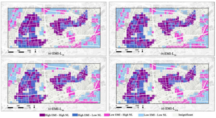
Spatial clustering of the Elderly Mobility Index and noise indicators
(3) There is a nonlinear relationship between noise priority intervention spaces (PIAs) and spatial indicators (SIs): Among three modeling methods (LR, RF, and XGBoost), the spatial indicators (SIs) constructed using the XGBoost algorithm have the best classification prediction ability for PIAs (identified based on L10 and EMI). In the prediction model, road area density, road landscape shape index, normalized vegetation index, average building height, and floor area ratio are important spatial indicators for identifying PIAs, with decreasing importance in that order. Grids with high values of road area density, road landscape shape index, average building height, and floor area ratio, and low values of normalized vegetation index are more likely to be identified as PIAs. Notably, when the values of the above spatial indicators reach a certain threshold, further changes in the indicator values no longer affect the likelihood of the grid being identified as PIAs.
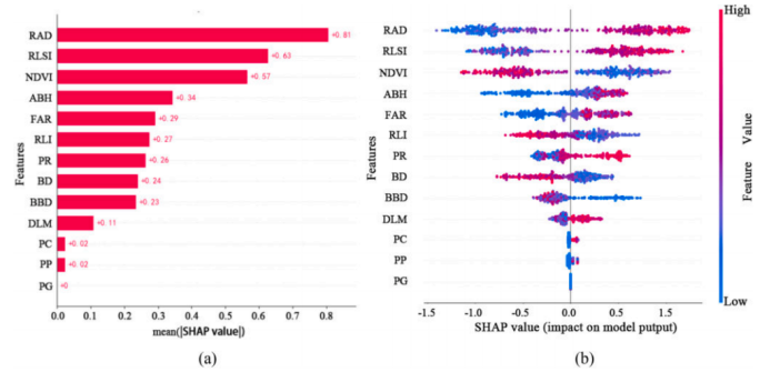
(a) Relative importance chart of spatial feature indicators; (b) Spatial feature indicator swarm plot