Encountering the Beauty of Scientific Research
March
Spring Feeling
Seeking Resonance of Inspiration



Gift to Readers
Doing scientific research involves a profound system of thought, requiring researchers to be logical, meticulous, and earnest. However, effort alone is not sufficient; often leveraging resources is more important than hard work. Additionally, one must have points of innovation and inspiration that gaze at the stars. Readers are advised to browse in the order of the table of contents to avoid suddenly falling into a dark maze without finding the way back. This may not reveal all the answers to your questions, but if it can clarify the clouds of doubt rising in your heart, it may create a spectacular sunset. If it brings you a deluge in your spiritual world, then take this opportunity to brush off the dust that has been lying there.
Perhaps, after the rain, the sky is clearer…
01
Overview
Wireless Rechargeable Sensor Networks (WRSN) are widely used in fields such as environmental and traffic monitoring, video surveillance, and healthcare, contributing to the improvement of urban living quality. However, providing continuous energy to sensors deployed in buildings, soil, or other hard-to-access locations is a challenge. To address this issue, we designed a new wireless charging system that utilizes the bus network in urban areas to assist UAVs (Unmanned Aerial Vehicles) in charging. Based on this new wireless charging system, we formulated the UAV scheduling problem to minimize the total time cost of UAVs while satisfying energy constraints and ensuring that all sensors can be charged. Subsequently, we proposed an approximate algorithm, DSA, to solve the energy-constrained UAV scheduling problem. To enhance the sustainability of WRSN tasks, we further formulated a UAV scheduling problem with sensor deadlines and proposed an approximate algorithm, DDSA, to find the scheduling scheme that maximizes the number of sensors charged by UAVs before the deadlines. Through extensive simulations, we demonstrated that DSA can reduce the total time cost by 84.83% compared to the greedy replenishment algorithm and can achieve an average of up to 5.98 times the total time cost of the optimal solution. Moreover, we also showed that DDSA can improve the sensor survival rate by 51.95% compared to the deadline greedy replenishment algorithm, achieving an average survival rate of 77.54% of the optimal solution.

1. Introduction
Wireless Rechargeable Sensor Networks (WRSN) play an important role in smart cities due to their advantages of providing continuous power supply through wireless charging networks and harvesting energy from the environment (such as solar and wind energy). WRSN has been applied in various fields, such as long-term environmental monitoring and vehicle traffic control. However, deploying sensor networks in hard-to-reach outdoor environments (such as precipitation analysis in mountainous areas and water quality monitoring) may increase the deployment and maintenance costs of wireless chargers. Moreover, in many sensing applications (such as structural monitoring under bridges and soil condition monitoring), it is challenging to harvest energy from the environment using solar panels and/or wind energy. Sensors can obtain energy from wireless chargers embedded in UAVs and store it in their own capacities. Previous studies have explored the feasibility of using UAVs capable of wirelessly transmitting energy to charge sensors, employing dedicated chargers carried by UAVs to fly over sensor networks and transmit energy to sensors via radio frequency signals. This UAV-based WRSN wireless charging can continuously replenish energy for sensors deployed in hard-to-reach outdoor environments without the need to deploy and maintain a wireless charging network.
Due to limited battery capacity, UAVs need to return to ground charging stations to recharge themselves. This increases the energy consumption of UAV flights and reduces charging efficiency. With limited energy capacity, UAVs find it challenging to charge sensors over vast areas. Efficiently charging UAVs is an interesting and important problem that has garnered widespread attention. Recent research [13] proposed a solution for charging UAVs by taking buses to continuously collect and transmit video streams from a multitude of Points of Interest (PoIs) in urban areas. [14] designed a new electric vehicle charging system that integrates the Online Electric Vehicle (OLEV) system [15] and Microwave Power Transmission (MPT) system, utilizing the bus network in urban areas. By leveraging the bus network, UAVs can not only recharge by taking buses but also extend the range of charging services. Meanwhile, buses are equipped with large-capacity batteries that can continuously obtain energy from the OLEV system or their fuel engines, thus having sufficient energy to charge UAVs. Additionally, due to the high prevalence and extensive coverage of bus networks in urban areas, buses provide abundant charging opportunities for UAVs.
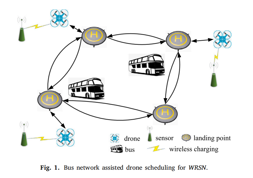
However, existing studies have separately examined UAV wireless charging for WRSN [12] and UAV scheduling that utilizes buses for charging [13]. In reality, energy should be efficiently transmitted among WRSN, UAVs, and buses to form a closed-loop wireless charging system. Therefore, we propose a bus network-assisted UAV wireless charging system for urban WRSN. The introduction of the bus network in the designed system not only accelerates the energy replenishment of UAVs but also reduces the energy consumption of UAVs charging WRSN. An example of our charging system is shown in Figure 1. The system includes one UAV, two buses, and three sensors. The UAV can take off from any sensor and a fixed location on a set of bus routes (referred to as landing points). Buses have their own regular schedules and can charge the UAV while it is on board. Sensors can be charged by the UAV. Thus, WRSN and the bus network together form a comprehensive network consisting of sensors, landing point segments connecting bus routes, and flight segments between sensors and landing points. The UAV takes the bus from the nearest landing point to recharge itself and, when it has sufficient energy, leaves the bus to charge at a landing point of the next sensor. The UAV then charges the sensor and flies back to the nearest landing point. Therefore, in this comprehensive network, the UAV obtains energy between any two landing points and consumes energy between any sensor and landing point.
In the designed system, the charging efficiency of the UAV and the sustainability of WRSN largely depend on the scheduling of the UAV. To our knowledge, there is currently no ready-made bus network-assisted UAV scheduling for charging WRSN. We considered two UAV scheduling scenarios based on the different requirements of sensing tasks. For the first scenario, we assume that the sensing task can tolerate some data loss and allows sensors to enter sleep mode to save energy. Therefore, in this case, UAV scheduling is only limited by the energy of the UAV. In the second scenario, the sensing task requires continuous sensing data (such as vehicle traffic control applications [5] and real-time environmental monitoring [16]), thus the death or sleep of sensors would significantly reduce sensing quality. Therefore, UAV scheduling is constrained by both the energy of the UAV and the deadline of the sensor’s sensing task.
Scheduling UAVs for sustainable charging of WRSN assisted by the bus network is a very challenging problem. First, since our goal is to schedule the UAV to access sensors only, it is not possible to obtain the UAV’s travel path by directly solving the Traveling Salesman Path Problem (TSPP) on the integrated network of WRSN and the bus network. Second, in the comprehensive network, finding the energy-constrained shortest path for UAVs during the bus ride from one sensor to the next is difficult. This is because there may be a mixed process of discharging and charging for UAVs between any two sensors. Therefore, the constrained shortest path algorithm [17] cannot be directly used to find our energy-constrained shortest path since it requires the constrained metric to be non-negative. Furthermore, UAV scheduling must ensure that each segment/flight segment meets the energy constraints of the UAV, meaning that the remaining energy of the UAV at the starting point of the segment/flight segment must not be less than the energy consumed through that segment. However, the remaining energy of the UAV depends on the previously selected segments/flight segments.
Our main contributions can be summarized as follows:
We designed a wireless charging system for WRSN assisted by the urban bus network through UAVs. To our knowledge, we are the first to study the UAV scheduling problem in this integrated wireless charging system.
We formulated the UAV scheduling and bus network (DSB) problem to minimize the time cost of UAVs charging all sensors under energy constraints and proposed an approximate algorithm—the UAV Scheduling Algorithm (DSA)—to solve the energy-constrained DSB problem.
Considering the continuous sensing tasks of WRSN, we further formulated the UAV scheduling and bus network with deadlines (DDSB) problem to maximize the number of sensors charged by UAVs under the dual constraints of UAV energy and sensor deadlines, and proposed an approximate algorithm—the Deadline UAV Scheduling Algorithm (DDSA)—to solve the energy-constrained DDSB problem.
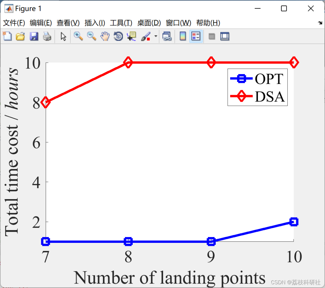
We conducted extensive simulations and field experiments on the proposed algorithms. Simulation results indicate that DSA can reduce the total time cost by 84.83% compared to the greedy replenishment algorithm and can achieve an average of up to 5.98 times the total time cost of the optimal solution. Then, DDSA can improve the sensor survival rate by 51.95% compared to the deadline greedy replenishment algorithm and achieve an average survival rate of 77.54% of the optimal solution.
The remainder of this paper is organized as follows: In Section 2, we review related research. In Section 3, we introduce the system model, formulate the DSB problem, and propose an approximate algorithm to solve the energy-constrained DSB problem. In Section 4, we formulate the DDSB problem and propose an approximate algorithm to solve the energy-constrained DDSB problem. In Sections 5 and 6, we conduct simulations and field experiments, respectively. In Section 7, we conclude this work.
7. Conclusion In this paper, we designed a UAV wireless charging system supported by the bus network for sensor networks in urban areas. Buses continuously charge through the OLEV system or their fuel engines, providing sufficient energy to charge UAVs. Sensors are charged by UAVs. We formulated the UAV scheduling and bus network (DSB) problem to minimize the total time cost of UAVs under energy constraints, ensuring that all sensors are charged exactly once by UAVs, and proposed an approximate algorithm to solve the energy-constrained DSB problem. To consider the sensor deadlines, we further formulated the UAV scheduling and bus network with deadlines (DDSB) problem to maximize the number of sensors charged by UAVs under the dual constraints of UAV energy and sensor deadlines, and proposed an approximate algorithm to solve the energy-constrained DDSB problem. Theoretical analysis, numerical simulations, and field experiments validate the efficiency and effectiveness of the proposed algorithms. Simulation results show that DSA can reduce the total time cost by 84.83% compared to the GRE algorithm, and can achieve an average of up to 5.98 times the total time cost of the optimal solution. Furthermore, results indicate that DDSA can improve the sensor survival rate by 51.95% compared to the DGRE algorithm, achieving an average survival rate of 77.54% of the optimal solution.
For detailed articles, please refer to Section 4 for downloads.

Operation Results
02

部分代码:

function [mypath,cost]=dijkstra(a,sb,db)
% 输入:a—邻接矩阵(aij)是指i到j之间的距离,可以是有向的
% sb—起点的标号, db—终点的标号
% 输出:mydistance—最短路的距离, mypath—最短路的路径
cost=0;
n=size(a,1); visited(1:n) = 0;
distance(1:n) = inf; % 保存起点到各顶点的最短距离
distance(sb) = 0; parent(1:n) = 0;
for i = 1: n-1
   temp=distance;
   id1=find(visited==1); %查找已经标号的点
   temp(id1)=inf; %已标号点的距离换成无穷
   [t, u] = min(temp); %找标号值最小的顶点
   visited(u) = 1; %标记已经标号的顶点
   id2=find(visited==0); %查找未标号的顶点
  for v = id2
    if a(u, v) + distance(u) < distance(v)
      distance(v) = distance(u) + a(u, v); %修改标号值
      parent(v) = u;
    end
  end
end
mypath = [];
if parent(db) ~= 0 %如果存在路!
   t = db;
   mypath = [db];
   while t ~= sb
     p = parent(t);
     mypath = [p mypath];
     t = p;
   end
end
mydistance = distance(db);
disp('dijkstra执行完毕')
return
end

function [mypath,cost]=dijkstra(a,sb,db)
% 输入:a—邻接矩阵(aij)是指i到j之间的距离,可以是有向的
% sb—起点的标号, db—终点的标号
% 输出:mydistance—最短路的距离, mypath—最短路的路径
cost=0;
n=size(a,1); visited(1:n) = 0;
distance(1:n) = inf; % 保存起点到各顶点的最短距离
distance(sb) = 0; parent(1:n) = 0;
for i = 1: n-1
   temp=distance;
   id1=find(visited==1); %查找已经标号的点
   temp(id1)=inf; %已标号点的距离换成无穷
   [t, u] = min(temp); %找标号值最小的顶点
   visited(u) = 1; %标记已经标号的顶点
   id2=find(visited==0); %查找未标号的顶点
  for v = id2
    if a(u, v) + distance(u) < distance(v)
      distance(v) = distance(u) + a(u, v); %修改标号值
      parent(v) = u;
    end
  end
end
mypath = [];
if parent(db) ~= 0 %如果存在路!
   t = db;
   mypath = [db];
   while t ~= sb
     p = parent(t);
     mypath = [p mypath];
     t = p;
   end
end
mydistance = distance(db);
disp('dijkstra执行完毕')
return
end
03
References
Some content in this article is sourced from the internet and will be cited or referenced. There may be omissions, so please feel free to contact us for removal if there are any discrepancies.

04
Matlab Code | Article Download