
Abstract: On July 17, 2025, the Center for Strategic and International Studies published a report titled “Air Defense and Missile Defense Networked Perception: The Concept of a Large-Scale Passive Sensor Network.” The research presented in this report proposes the construction of a distributed passive sensor network as a complementary means to active radar detection. The following text provides a detailed introduction to this research, including the value of passive sensors and the considerations for building a passive sensor network.
Keywords:Passive Sensors, Air Defense, Missile Defense, Distributed Deployment, Radar
(Image source from CSIS report, please contact for removal if infringing)
The research indicates that current adversaries of the United States widely possess surveillance and targeting capabilities, making it easier for them to identify weaknesses in friendly air defense and missile defense systems; moreover, the strike range of out-of-area weapons has further expanded, with more countries or entities capable of precision strikes, making air defense and missile defense capabilities crucial.
Traditional air defense and missile defense systems primarily use radar for target detection. However, the energy emitted by radar creates characteristic signals that can be easily detected and targeted by adversaries. For friendly forces, to build a more survivable sensor structure, various camouflage, concealment, and deception methods need to be employed, such as reducing radar signal characteristics and using decoys for interference.
Therefore, using passive sensor systems that receive energy rather than emit it can play a significant role. By deploying a large number of ground sensors as a complementary means to precision radar, the friendly air defense and missile defense network can withstand complex airstrikes and missile attacks.
Passive sensors (including electro-optical/infrared, acoustic, and radio frequency sensors) are inferior to traditional air defense radars in terms of detection range and resolution. However, if a sufficient number of sensors are deployed and constructed into a network, combined with machine learning systems for analysis, this sensor network can not only achieve target tracking but also build a more robust and resilient defense system.
Secondly, merely increasing the number of sensors does not guarantee the survivability of the sensor network; it is equally important to reduce the detectability of air defense and missile defense sensors. The technical means to achieve the construction of a passive sensor network are largely already in place. For example, Ukraine has deployed an acoustic sensor system, with its “Sky Fortress” system equipped with over 9,500 sensors to reduce the use of high-end air defense and missile defense radars and thwart Russian airstrikes. The following text will explore a conceptual passive sensor network that detects three types of threats: aerial platforms, hypersonic weapons, and ballistic missiles, and analyze it in conjunction with site selection, logistical support, network resources, and weather factors.
Sensor Network Design
The current planning methods have not resolved the site selection problem for hundreds or thousands of sensors, as effectively covering the battlefield with sensors is not simply a matter of deploying them in a grid. Many factors affect the design of large-scale sensor networks, including line of sight and terrain obstructions, logistical and mobility constraints, network bandwidth, and weather conditions. To explore the relevant influencing factors, this research uses the Polish region as an example to construct a theoretical distribution plan for electro-optical/infrared sensors. Poland has various terrain features and an area comparable to several key regions in major combat zones (including the Indo-Pacific region), making it suitable as a test case for deploying sensor networks. The testing process of the plan is roughly as follows:
-
Import the open-source digital elevation model of the Polish region into a custom Python script and calculate the line of sight range of sensors for targets at different heights to generate a preliminary deployment plan;
-
The script uses a genetic optimization algorithm (NGSA-II) and binary search method to calculate a plan that covers 99.5% of the area with the least number of sensors;
-
This plan is then imported into the SmartSET air defense and missile defense planning tool to simulate specific combat scenarios.
The attack scenarios constructed by the research team include 20 generic medium-range ballistic missile threats (covering high-throw and low-extend ballistic types) and 4 generic hypersonic glide vehicle threats. The following text will analyze effective deployment plans for the sensor network from four aspects: mission planning, support and mobility, network resources, and weather.
Mission Planning
Ground sensors have limitations in tracking low-flying targets. The curvature of the Earth and surrounding terrain features can obstruct the line of sight of ground sensors when observing at low elevation angles, thus limiting their maximum detection range; therefore, sensors are typically deployed at higher altitudes.
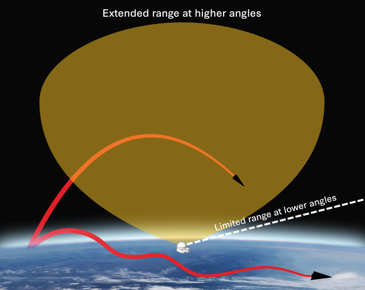
Figure 1. Coverage range of electro-optical/infrared sensors (Image source from CSIS report, please contact for removal if infringing)
Specifically, a sensor installed on a 5-meter-high mast can detect a low-flying cruise missile at a height of 250 meters from a distance of up to 64 kilometers; however, if the same sensor is installed on a 5,000-meter-high aerostat, its detection range can reach 309 kilometers, an increase of 382%.
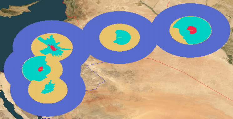
Figure 2. Line of sight limitations for unmanned systems, aerial platforms, and hypersonic threats, where red represents targets at 250 meters, blue at 1,000 meters, yellow at 10,000 meters, and purple at 20,000 meters (Image source from CSIS report, please contact for removal if infringing)
1.Multi-Point Deployment and Site Selection
Even high-end sensors have their maximum detection range limited by line of sight. Therefore, a network system composed of small, short-range sensors may achieve similar effects to a long-range sensor network, at least when detecting low-flying targets. Additionally, deploying long-range passive sensors (such as electro-optical/infrared sensors) at high altitudes can enhance coverage of high-altitude targets and satellites. In summary, a multi-point deployed sensor network can place sensors in areas with multiple angles of view, thus overcoming detection capabilities obstructed by high terrain.
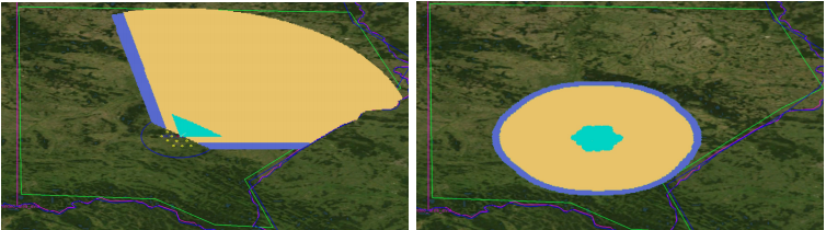
Figure 3. Assuming the deployment of one “Patriot” radar with a minimum elevation angle of 5° and 19 infrared sensors with a minimum elevation angle of 10°, the detection coverage for aerial targets at heights of 1 kilometer (blue), 10 kilometers (yellow), and 20 kilometers (purple) is illustrated (Image source from CSIS report, please contact for removal if infringing)
The value of constructing a passive sensor network is evident; however, the challenge lies in how to plan this deployment network. When selecting a location for a single “Patriot” air defense radar system, Army air defense planners need to use colored elevation maps (which clearly present ridge and valley locations, providing a basis for determining the most likely approach paths of aerial targets) to comprehensively consider geographical constraints, protected assets, and threat approach areas to determine the optimal deployment location for fire units. Even deploying a single radar involves a very complex site selection process, requiring consideration of potential missile launch locations, tactical mobility, and various other factors. As the number of sensors increases, the complexity of these issues grows exponentially, often requiring extensive preliminary work and coordination among multiple levels of operational planners.
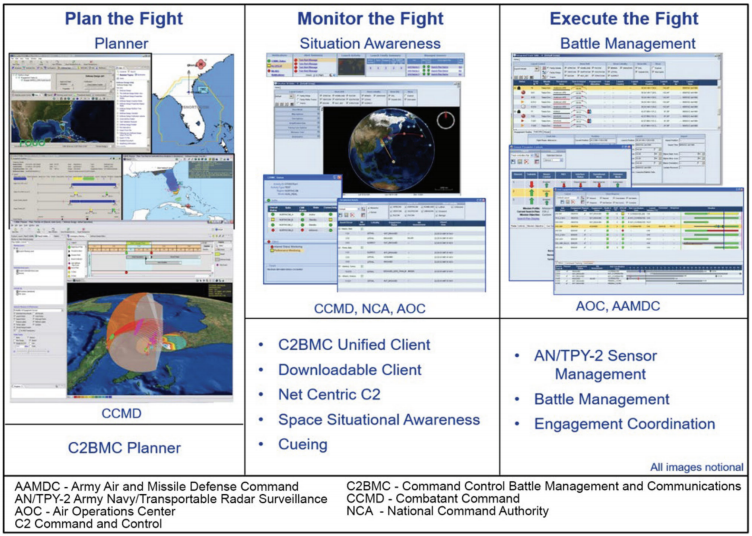
Figure 4. Joint operational sensor deployment planning tool, including C2BMC planner (Image source from CSIS report, please contact for removal if infringing)
Note: The U.S. Army describes the C2BMC planner as a software tool used to coordinate and integrate multiple theater defense plans into a broader regional defense plan, helping to optimize sensor coverage and weapon system deployment locations before deploying combat units.
To determine how to deploy a large number of distributed sensors, computational methods are required. In the past, when relying on a small number of high-end sensors, deploying sensors might only require selecting the highest terrain locations on a map. However, in constructing a large-scale sensor network, the complexity of the problem increases dramatically, as the location of each sensor affects the deployment of other sensors, and the coverage range of each sensor varies based on its location.
Achieving the largest coverage area with the fewest sensors (the “coverage problem”) does not have an optimal solution from a mathematical perspective. However, heuristic algorithms can be used to approach an optimal solution. Research has already utilized such methods to optimize air defense sensor deployment, particularly for covering low-flying targets that are easily obstructed by terrain. Some studies have employed a “greedy” heuristic algorithm: the algorithm first finds the point on the terrain map that can cover the most area and places a sensor there; it then searches for the point that can cover the largest remaining area and places a second sensor; this process is repeated until the entire area is essentially covered. The research presented in this article employs a genetic algorithm: the algorithm repeatedly tests different deployment schemes, retaining the best-performing schemes and eliminating the poorly performing ones. This process is akin to natural selection, ultimately leading the algorithm to derive a sensor deployment scheme that is close to optimal.
2. Height of Threat Targets
For different threat targets such as hypersonic weapons/ballistic missiles, aerial vehicles, and cruise missiles/drones, researchers conducted multi-day calculations using customized optimization scripts to derive corresponding deployment configuration schemes. The results show that the optimal site selection criteria depend on the expected height of the threat targets:
-
For hypersonic and ballistic weapons typically flying at altitudes above 20 kilometers, a sensor constrained by the horizon can achieve full coverage;
-
For targets flying at an altitude of 2 kilometers (such as tactical aircraft), the required number of sensors increases to 9;
-
For targets at only 200 meters (such as drone systems), the number of sensors will surge to 396.
If three-dimensional tracking is required (i.e., each target must be covered by at least two sensors simultaneously), the number of required sensors will further increase. This study did not consider this situation to save computation time.
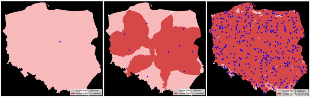
Figure 4. One sensor is sufficient for a target height of 20 kilometers (left), 9 sensors are needed for a target height of 2 kilometers (middle), and 396 sensors are needed for a target height of 200 meters (right) (Image source from CSIS report, please contact for removal if infringing)
3.Limitations of Sensor Angles
However, as mentioned earlier, electro-optical/infrared sensors face challenges in detecting targets at low elevation angles, as the observation path at this time passes through a longer atmospheric column. As shown in Figure 5, if the minimum elevation angle of the sensor is limited to 5° or higher, then at least 4 sensors are needed to detect a hypersonic target at an altitude of 20 kilometers; if the minimum elevation angle is limited to 10° or higher, then 14 sensors are required. In larger-scale deployment architectures, angle limitations significantly increase the number of required sensors. For example, nearly 400 sensors are needed just to cover drone detection.
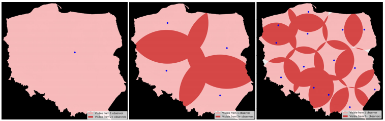
Figure 5. Sensor with no angle limitation requires only one sensor (left), sensor with a minimum elevation angle of 5° requires 4 sensors (middle), sensor with a minimum elevation angle of 10° requires 14 sensors (right) (Image source from CSIS report, please contact for removal if infringing)
Nevertheless, in some cases, simple deployment schemes can still be effective. Even deploying a few low-end sensors at the front line can assist existing radars by indicating specific airspace that needs focused searching, reducing radar emission time, speeding up target interception, and potentially helping to extend interception ranges. In the context of the Russia-Ukraine scenario, Ukraine’s sensor network allows high-value radars to remain inactive when not necessary, maintaining concealment. Even if the sensors only provide an imprecise indication of the target’s approximate location in advance, they can expand the operational space of existing systems and enhance survivability. These advantages can be validated through a hypothetical scenario.
4. Simulation to Validate the Effectiveness of Passive Sensor Networks
In the hypothetical attack designed by this research, the configuration of the aforementioned 14 sensors (with a minimum elevation angle of 10°) was deployed into the SmartSet simulation tool. Assuming that Russia launches a wave of 24 missiles, including 4 hypersonic glide missiles and 20 generic medium-range ballistic missiles, targeting NATO facilities in western Poland. To simulate interception effects, a “Patriot” missile defense position located in Szczecin and a land-based Aegis missile defense system position located in Redzikowo were set up, considering both scenarios with and without the configuration of the electro-optical/infrared sensor network. Given computational limitations, each electro-optical/infrared sensor was modeled to have the capability of independently achieving three-dimensional tracking. If dual sensors are required for three-dimensional tracking, it can be assumed that the total number of required sensors does not exceed 28.
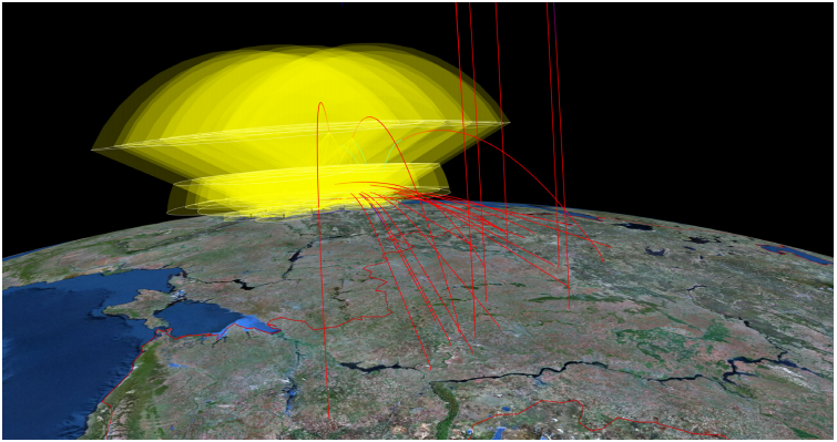
Figure 6. A network sensor architecture composed of 14 sensors (assuming a minimum elevation angle of 10 degrees) was imported into the SmartSET system and used for simulation testing of a hypothetical attack (Image source from CSIS report, please contact for removal if infringing)
The simulation results show that compared to the defense system without a sensor network, the defense system equipped with a sensor network:
(1) Increased the number of interceptions by 26%, intercepting 5 more medium-range ballistic missiles;
(2) Was able to detect and intercept targets earlier— sensors deployed in forward positions detected a hypersonic glide vehicle target 3 minutes and 44 seconds earlier.
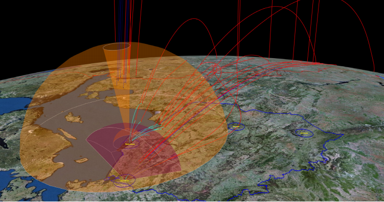
Figure 7. Comparison of defense schemes and illustration of the attack scenario (Image source from CSIS report, please contact for removal if infringing)
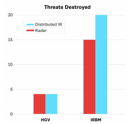
Figure 8. Impact of radar and distributed electro-optical sensor networks on interception results (Image source from CSIS report, please contact for removal if infringing)
Logistical Support and Mobility
Deploying a distributed ground sensor network will require specialized logistics and support methods. Although deploying a large number of equipment over vast areas presents new challenges, using compact sensors is expected to reduce the high demands for manpower and transportation of existing systems. For example, transporting a basic “Patriot” system—i.e., the minimum operational unit (MEP)—may require up to 7 C-17 transport aircraft. In early 2025, deploying a single “Patriot” battalion to the Middle East involved up to 73 C-17 transport flights. Therefore, constructing a sensor network that is more widely distributed and requires less manpower may present new opportunities for strategic mobility, but it will also bring new challenges for tactical mobility.
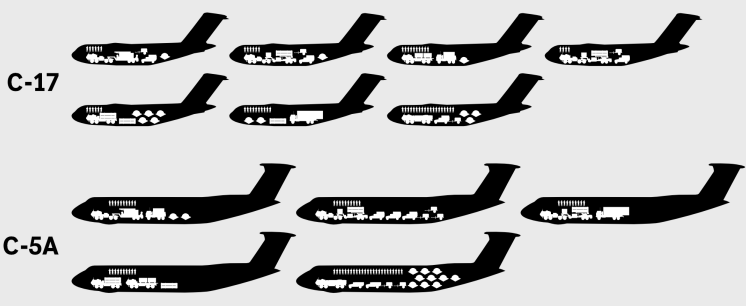
Figure 9. Strategic airlift of a single “Patriot” minimum operational unit requires 7 C-17 transport aircraft or 5 C-5A transport aircraft (Image source from CSIS report, please contact for removal if infringing)
At the tactical level, the logistical demands of deploying and resupplying a large number of equipment over vast areas will present new challenges for mission planners. For instance, deployment locations need to be close to roads, which may impose certain restrictions on the optimal deployment locations of equipment. Meanwhile, while the protection needs of equipment entities can be met through modern encryption and anti-tampering technologies, if personnel are required to guard the sensor network, it will pose additional challenges.
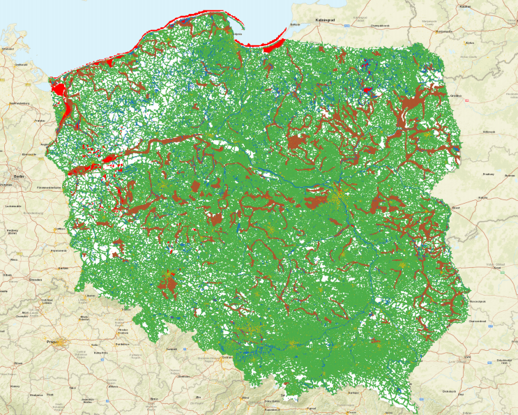
Figure 10. Mobility constraints in the Polish region: the green area is within one kilometer of roads, the brown area is muddy, marshy, or impassable, the red area has a slope greater than 5%, and the blue area is water (Image source from CSIS report, please contact for removal if infringing)
At the operational level, to achieve widespread deployment of the sensor network, the military branches need to further integrate existing mobility planning analysis tools with air defense and missile defense mission planning tools. If sensors rely on centralized power supply, it may expose civilian power grids to enemy attacks, thus requiring the construction of distributed power supply networks using high-performance batteries, solar power, motors, or fuel cells.
Moreover, the physical communication backbone connecting the sensor network also needs to be designed and deployed with caution. To this end, joint forces can draw on past experiences in deploying distributed ground systems. For example, the current space surveillance telescope network typically deploys sensors in remote areas while minimizing personnel presence. The U.S. Air Force has deployed 400 unmanned nuclear missile silos nationwide, relying on remote monitoring and anti-tampering measures to ensure their safety. The U.S. Army’s “Patriot” system is also beginning to transition to using distributed nodes for communication on the battlefield, such as the “Remote Intercept Guidance”-360 (RIG-360). Finally, Ukraine’s combat experience indicates that sensors can be co-located with existing resources, including cellular communication infrastructure.
The ability to deploy dozens or even hundreds of sensors in the same combat zone has significantly increased. Many terrains are suitable for distributed sensor deployment. For example, in Poland, most land areas are within one kilometer of roads, with only a few areas unsuitable for deployment due to muddy, marshy, or poor soil conditions. In maritime operational areas, multiple military branches, startups, and national laboratories are experimenting with using small unmanned boats and other swarm equipment as potential carriers for sensor networks. As long as resources are sufficient and measures are effective, the logistical challenges associated with deploying a large number of sensors can be addressed.
Network Requirements
Previous wide-area electro-optical sensor systems (such as Gorgon Stare) generated raw image data at the petabyte (PB) level during operation, significantly increasing computational demands and posing challenges for analysts. Such architectures consume a large amount of communication bandwidth. Even in the aforementioned hypothetical scenario, the communication volume generated by the distributed sensor network is far greater than that of systems without such networks. Over the past decade since the launch of Gorgon Stare, system architects have significantly alleviated data bandwidth pressure through edge preprocessing. For example, the tracking layer satellites of the “Dispersed Operational Personnel Space Architecture (PWSA)” preprocess raw image data into two-dimensional trajectory information before transmitting it to operational personnel. Germany’s previous ABF project used more basic filtering algorithms to generate target trajectories and discard unnecessary information.
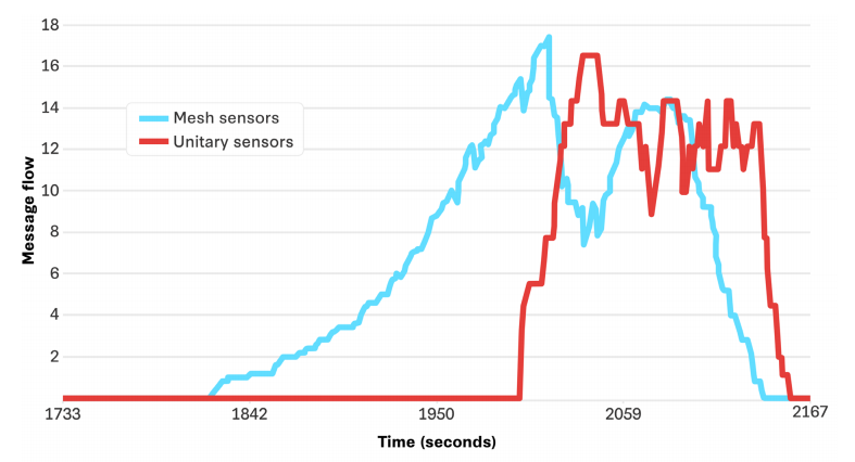
Figure 11. Data packet exchange in the Russia-Poland attack scenario (Image source from CSIS report, please contact for removal if infringing)
Although full-quality telemetry data must still be obtained to optimize tracking algorithms, when designing large-scale ground sensor systems, special attention must be paid to data reduction issues and fully utilize the increasingly available high-performance computing resources. In many ways, the issues of edge processing have been greatly alleviated. Compared to spacecraft, ground equipment has far fewer limitations in terms of power consumption, weight, and radiation resistance, allowing it to be equipped with stronger onboard computing capabilities.
More importantly, technologies supporting rapid edge processing have made significant progress over the past two decades; pipelines for processing images at the level of billions of pixels have now become widespread and commercialized; graphics processing units (GPUs) and embedded computing systems supporting new tracking algorithms have also seen similar advancements. The field of computer vision has experienced explosive growth: from 2010 to 2025, the submission volume to the Computer Vision and Pattern Recognition (CVPR) conference surged by 655%, while the performance of computer vision hardware has roughly doubled every two years. Today, constructing distributed electro-optical/infrared systems can fully benefit from the robust ecosystem of existing hardware, algorithms, and software. However, careful consideration must be given to the vulnerabilities of artificial intelligence/machine learning algorithms in responding to attacks (such as deception and data poisoning), and robust security measures and continuous monitoring should be implemented to mitigate these risks.
Weather Factors
For electro-optical/infrared sensor networks, the most severe challenge may be adverse weather conditions. Although this sensor network has significant advantages in coverage range and detection distance when detecting high-altitude targets, adverse weather can reduce its visibility by several orders of magnitude.
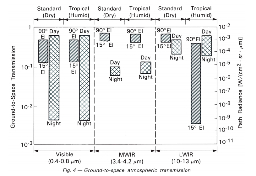
Figure 12. Atmospheric transmission at different elevations, day/night, and humidity (Image source from MIT Lincoln Laboratory, please contact for removal if infringing)
However, the challenges posed by weather not only affect the deployment of electro-optical/infrared sensors but also impact the design of various emerging capabilities. For instance, the performance of directed energy systems such as high-energy lasers is similarly limited in fog, haze, or humid environments. In this sense, deploying electro-optical/infrared sensor networks may, in turn, promote the integrated application of next-generation military meteorological forecasting and measurement systems. In-depth understanding of airflow disturbances, distributed deployment of weather sensors, and the adoption of new AI predictive models may revolutionize the joint planning of various operational capabilities, not limited to electro-optical/infrared sensors.
Future mission planners involving directed energy systems or electro-optical/infrared sensors must design dynamically adjustable operational configurations based on anticipated weather conditions and achieve synergy with existing weather-adaptive sensors and interceptors. For example, sensor deployment locations can be dynamically adjusted based on optimal and worst-case weather scenarios, and coordinated with existing radars to maintain ideal coverage.
Furthermore, the construction of the electro-optical/infrared sensor network discussed here is only one form of passive sensing. The challenges posed by weather further highlight the necessity of integrating sensor networks with other passive sensing methods and existing active architectures. Passive multi-base radar, passive radio frequency detection, and acoustic systems may all play a role.
Conclusion
In the face of complex and highly integrated attack threats, existing air defense and missile defense architectures urgently need enhancement. The research discussed in this article, through multi-point, distributed deployment of electro-optical/infrared sensors to form a detection network, can help cover areas with complex terrain, save radar resources, and identify the authenticity of targets.
Large-scale deployment of passive sensors still faces multiple challenges, including site selection, network connectivity, and adverse weather factors. However, the continuous decrease in the costs of microelectronics, networking equipment, sensors, and software makes the successful construction of this supplementary detection means more likely and less costly. In the long run, this will enhance the effectiveness of air defense and missile defense systems, enabling friendly forces to better respond to the current strategic environment.
This article is sourced from: Yuanting Defense

Follow the public account for more information
Membership application Please reply “individual member” or “unit member” in the public account
Welcome to follow the media matrix of the China Command and Control Society

CICC Official Douyin

CICC Toutiao Account

CICC Weibo Account

CICC Official Website

CICC Official WeChat Account

Journal of Command and Control Official Website

International Unmanned Systems Conference Official Website

China Command and Control Conference Official Website

National Wargaming Competition

National Aerial Intelligent Game Competition

Sohu Account

Yidian Account